Category: Uncategorized

  • On the Hudson with Henry


    Hello virtual crew members and fellow adventurers!

    Henry Hudson here helping the skipper pilot up the Hudson River to the Erie Canal.  The crew passed some memorable scenery as they left Haverstraw Bay and headed to Hyde Park.  The Bay is the widest point on the river, about 3 miles across from the east to west bank.  After a short stay in Hyde Park to explore the area, the crew then made their way to Waterford where they will enter the NY Canal System.

    But first I had to give the skipper a little sun dial training.  Seems the modern skipper relies on gadgets and GPS to navigate and they have lost the skills we old salts used to have to safely travel these waters. 

    IMG_0017

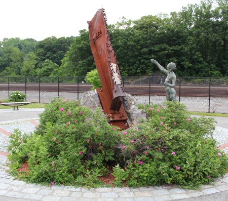
    The skipper came across a sundial – 9/11 Memorial while he was out riding his bicycle in Croton on Hudson Village.  The gnomon, the piece that sticks up and casts the shadow, was actually a steal beam from the twin towers.  Red bricks were then laid to create the hour-lines.  At the end of the hour-lines were medallions to represent the time as the shadow passed by. 


    IMG_0023
    Bear Mountain Bridge

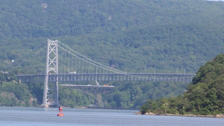
    The crew shoved off from the dock on Tuesday and headed north.  One of the first features passed was Bear Mountain which rose to a height of 1305 feet above the River.  The Appalachian Trail crosses the Hudson River at the Bear Mountain Bridge.  The crew saw hikers on the bridge 155 feet overhead and wondered if any were section hikers, since it would be too early for through hikers at this point.


    Appalachian Trail (AT) Factoid –  The trail from Bear Mountain to Delaware Water Gap opened October 7, 1923, and was the first section opened of the famed AT.

    The Skipper and Admiral dream of through hiking the AT after completing this season of boating America’s waterways.

    IMG_0028
    West Point at a distance

    West Point was the next landmark along this section of River.  As the crew came around the next bend in the River at Con Hook, they could see West Point on the western shore about 5.5 nautical miles up-river.


    In the revolutionary war the American’s stretched a chain from the west bank to the east bank to prevent the British from getting north of West Point.  Each chain link was 2 feet long.


    Another 5 nautical miles up-river the crew passed Pollepel Island.  The Island is better known as Bannerman Island to the locals.  There is a deteriorating castle on the Island that has quite the story to tell. 

    IMG_0047
    Bannerman Castle

    Buried on an island in the Hudson, beneath the brittle body of century old castle walls and thin hair of tangled vines, lie Civil War bayonet scabbards and the ashes of Irish linen bed sheets.


    This is the remnant of a Scotsman’s fortress called Bannerman Castle — built not as a home, but as an arsenal for his immense collection of weapons.  To read the whole story, click on the title: Bannerman Island: A Mystery Island on the Hudson


    Engraving of  Washington’s Headquarters, 1777

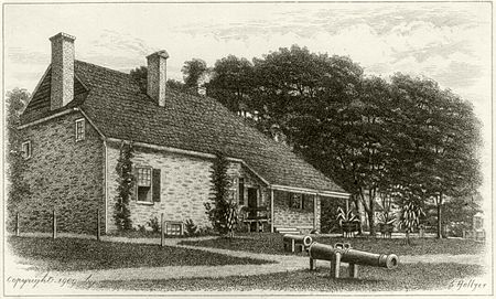
    Four nautical miles further up-river and the crew passed George Washington’s 1782-1783 Headquarters in Newburgh.  The Hasbrouck House is where George issued the Proclamation For Peace that ended the Revolutionary War.  The house is the oldest house in Newburgh, and also is the first property acquired and preserved by any state in the US for historic reasons.


    Another 4 nautical miles and the crew passed under the Mid-Hudson Suspension Bridge.  The crew is about half way to the Erie Canal.  The crew pulled into the Hyde Park Marina to spend several days exploring the sights of the mid-hudson.

    Shore Excursions in Dutchess County

    The Hudson River Valley is rich in history going all the way back to 1609 when I first sailed these waters.  The heavy Dutch influence is still seen today, mostly in the naming conventions that is still in use.  For example, a ‘kill’ in Dutch is a creek.  Eleanor Roosevelt’s home is named Val Kill Cottage, or Cottage on the Creek.

    With so much history in the area, the challenge is to narrow down the list of must see things to do, to a manageable number.  On this trip, the crew decided to walk the Val Kill Cottage property, visit the Hudson River Maritime Museum, Vanderbilt Mansion, FDR Library and Museum, the Culinary Institute of America, and West Point.  To see and do these things the crew rented a car for three days.

    IMG_0063
    Still Waters II at Hyde Park Marina, viewed from Walkway Over the Hudson

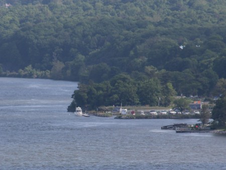
    But before setting off on Wednesday morning, the skipper noticed that one of the bridges in Poughkeepsie had been converted from a rail to trail bike ride.  It was about two miles from the marina to the trail, and then a 4.5 mile loop over the Walkway Over the Hudson Bridge to the Mid-Hudson Bridge, and then two miles back to the marina.


    IMG_1658As often happens on the explorations, the skipper stumbled over an exciting exhibit.  On the Mid-Hudson Bridge, someone had actually created 12 tracks of music that one can listen to.  All the music was made by beating on the bridge.  Very entertaining.

    The Mid-Hudson Bridge was done as a proof of concept to attempt the same thing on the Eifel Tower.  The Bridge Music turned out to be a success and he went on to also produce Tower Music.


    For a mobile web tour of the bridge and area, visit walkway

    Kingston, New York

    The first settlers arrived in Kingston in 1652, which makes the village the third oldest in New York State.  Kingston was also the first capital of New York.

    Historic Old Dutch Church

    Founded in 1659, the church is often referred to as ‘Kingston’s Cathedral.’  The church is built with native stone, showing Greek, Italian, and Egyptian influences.  The architect used symbolism of the Christian Church in using 3’s, 5’s and 7’s in the interior design.  

    Three stands for the trinity: Father, Son, and Holy Ghost.  There are three entrances, three aisles, and three pulpit chairs.

    Five stands for the 5 senses.  There are five windows on each side, five balcony arches with five columns.

    Seven stands for the days of creation.  There are two pairs of seven branch candle holders.

    IMG_0090The stained glass memorial window behind the pulpit was designed by Louis Comfort Tiffany. 

    The Praying Angel, designed by German sculptor, Carl Burbel, took first prize for bronze work at the 1893 Worlds Fair.  (The angel on the right side of pic.)

    While walking the grounds of the old church, the skipper tried to enter the church but found the door locked.  As the crew was walking away, a young man came up to the crew and asked if they would like to go inside.  Of course the answer was yes.  The young man unlocked the door, turned the church lights on, and basically gave the crew the run of the place to look around.

    Hudson River Maritime Museum

    IMG_0075
    Model of my ship – Half Moon

    The museum did a fantastic job of explaining the history of and uses of the Hudson River.


     Two of the more interesting things were the ice sailing and ice harvesting exhibits. 


    IMG_0078
    Ice sailboat

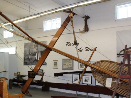
    The museum actually had FDR’s ice sailboat on exhibit.  Films showing ice sailing captured these contraptions sailing in excess of 100 mph over the ice.


    The ice harvesting reached a peak in the early 1900’s but was put out of business with the invention of electricity and refrigeration.  However, in its hey-day, there were over a hundred business cutting large chunks of ice and storing the blocks till summer.  Then selling the blocks of ice to customers in NYC. 

     Hyde Park

    Vanderbilt Mansion – Hyde Park – this mansion was purchased by Frederick and Louise Vanderbilt as a spring and fall cottage in 1895. The couple spent $2.25 million furnishing and updating the estate.  The couple had no children, so when Frederick died in 1938, he left the Hyde Park estate to a niece.  She did not want the head ache so she tried selling the estate.  Eventually dropping the price all the way to $250,000.  After no takers, she donated the estate to the government in 1940.

    FDR Library and Museum – FDR actually designed his library in the Dutch colonial style.  Unlike the presidential libraries that followed, FDR actually used this facility while sitting as the president.  The crew spent four hours wandering the exhibits and could easily spend another full day.

    The skipper was humored though by Eleanor.  The library had an exhibit of items found in her purse when she died.  Amongst the credit cards, and ID’s were about 10 different prayers she carried with her and a New York gun permit.  Can you believe it, a praying, gun toting, New York progressive.  My, how times have changed. 

    Culinary Institute of America

    IMG_0057The crew stopped in here for lunch and also took the tour.  The Institute was actually started by two women following WWII to help returning veterans learn new skills and find work.

    The sturgeon statue is made of knives, forks, and spoons.  The fish was selected because it makes its home in the Hudson River and brings us caviar.


    IMG_1659
    Gastrotypographicalassemblage at the Culinary Institute


    West Point

    IMG_0149The crew visited the Army Museum.  An interesting thread that first appeared on a plaque outside West Point, reappeared in the museum, and ended at the cemetery is the story of Susan and Anna Warner.

    The two sisters are the only female civilians buried in the cemetery.  For decades the two women taught Sunday School lessons to the Cadets who would row across the Hudson River to their home on Constitution Island.  Susan died in 1885, but Anna continued teaching the cadets until her death in 1915.  Dwight D, Eisenhower was a student of Anna’s.  Anna is also known as the author of the song, ‘Jesus Loves Me.’

    On Saturday morning the crew decided to push further north up the Hudson and left the dock at 0915.  While throwing the lines off the boat, an old man approached the skipper and asked if Henry Hudson was aboard.  When I heard my name, I looked down from the helm and saw my old friend, Rip.  You might recall that when Rip wandered into the woods he met my crew before falling into a deep sleep.

    Since Rip knows these woods we gave him a ride north to New Brunswick.  Along the way he pointed out landmarks and told stories of long ago. 

    IMG_0161When we passed the Esopus Island, Rip informed us that we were now out of the brackish water, and would be in fresh water the rest of the way north.  He mentioned that we will still feel the effects of the tides until we get to the Troy Lock north of Albany.

    Rip pointed out the Esopus Lighthouse.  The light was placed in service back in 1839.

    IMG_0164Further up the river we passed the Kingston Lighthouse.  Rip informed us that it was originally built in 1838.


    Just south of Albany, the crew passed under the Rip van Winkle fixed Bridge, and Rip decided it was time for a nap.  We let him disembark under the bridge and I waved goodbye to my old friend.  Soon after dropping Rip off, the crew motored up the side of Houghtailing  Island and anchored for the night.

    On Sunday the crew weighed anchor in the rain and made their way north of Albany and then on to the Troy Lock.  This is actually the furthest north I made it during my 1609 explorations of the region.

    IMG_0183
    Waiting for lock doors to open and a green light to enter

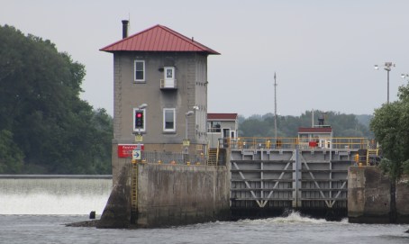
    The lock raised Still Waters II 14 feet.  Now that the crew has passed the lock, the crew will not have to deal with any tidal effects for a while.


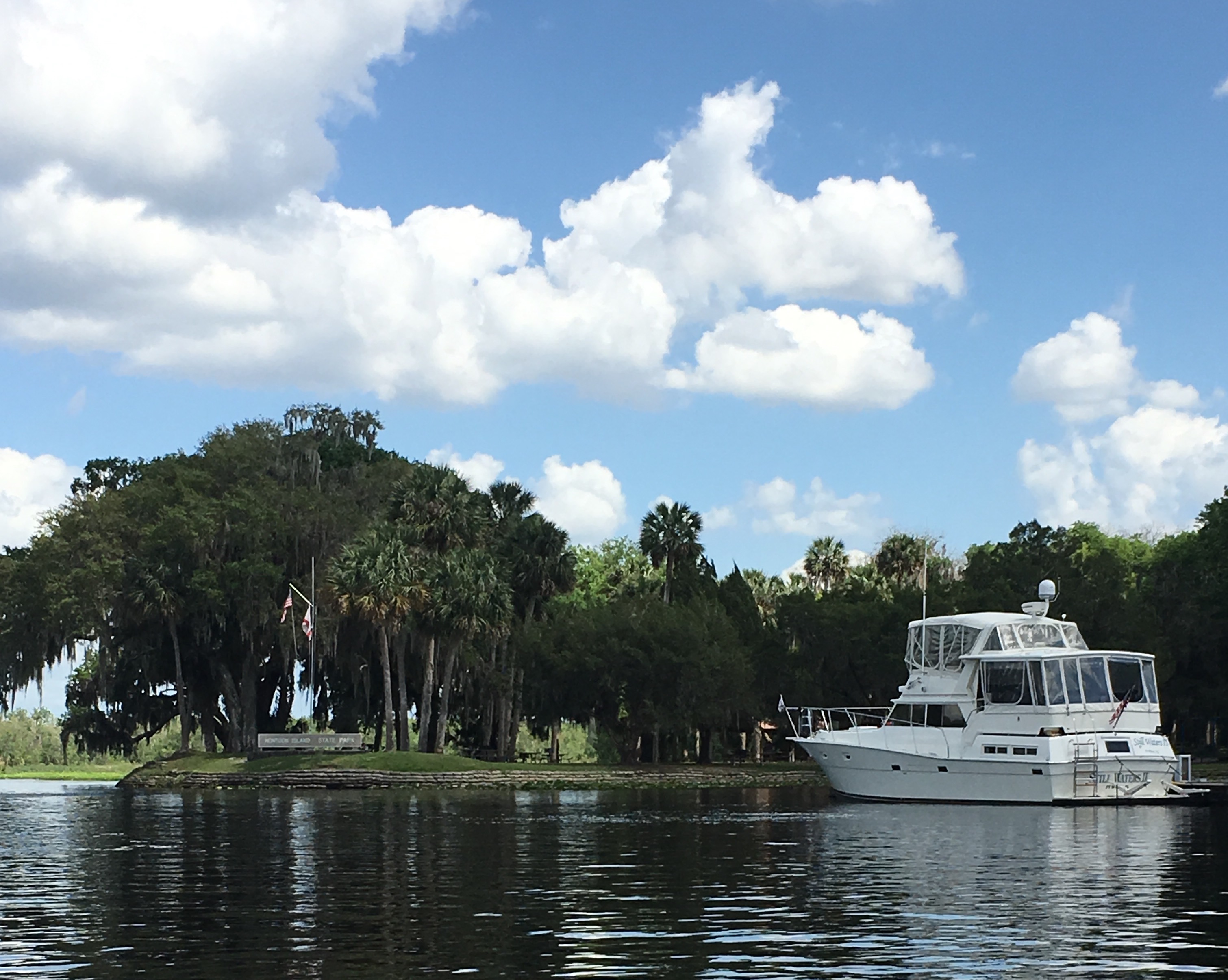
    Also, after passing the lock, the crew passed green ‘1’ which is the furthest east on the basic route of the Great Loop.  The boat in the pic below is to the starboard of the green 1 can floating in the water.

    IMG_0186
    Left turn at the green 1 marker and you go to Erie Canal.  Head right under the bridge and you go to the Champlain Canal.


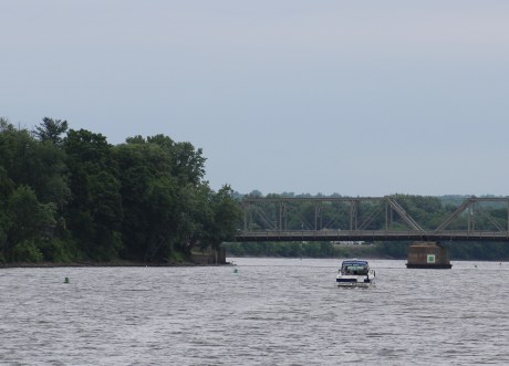
    The crew docked at the Waterford Town Dock.  The skipper went and bought their pass to transient the NY Canal System.  The crew will make final preps on Monday to make the canal passage.  The big question right now is whether to take the Erie Canal west or the Champlain Canal to the north.

    IMG_0189

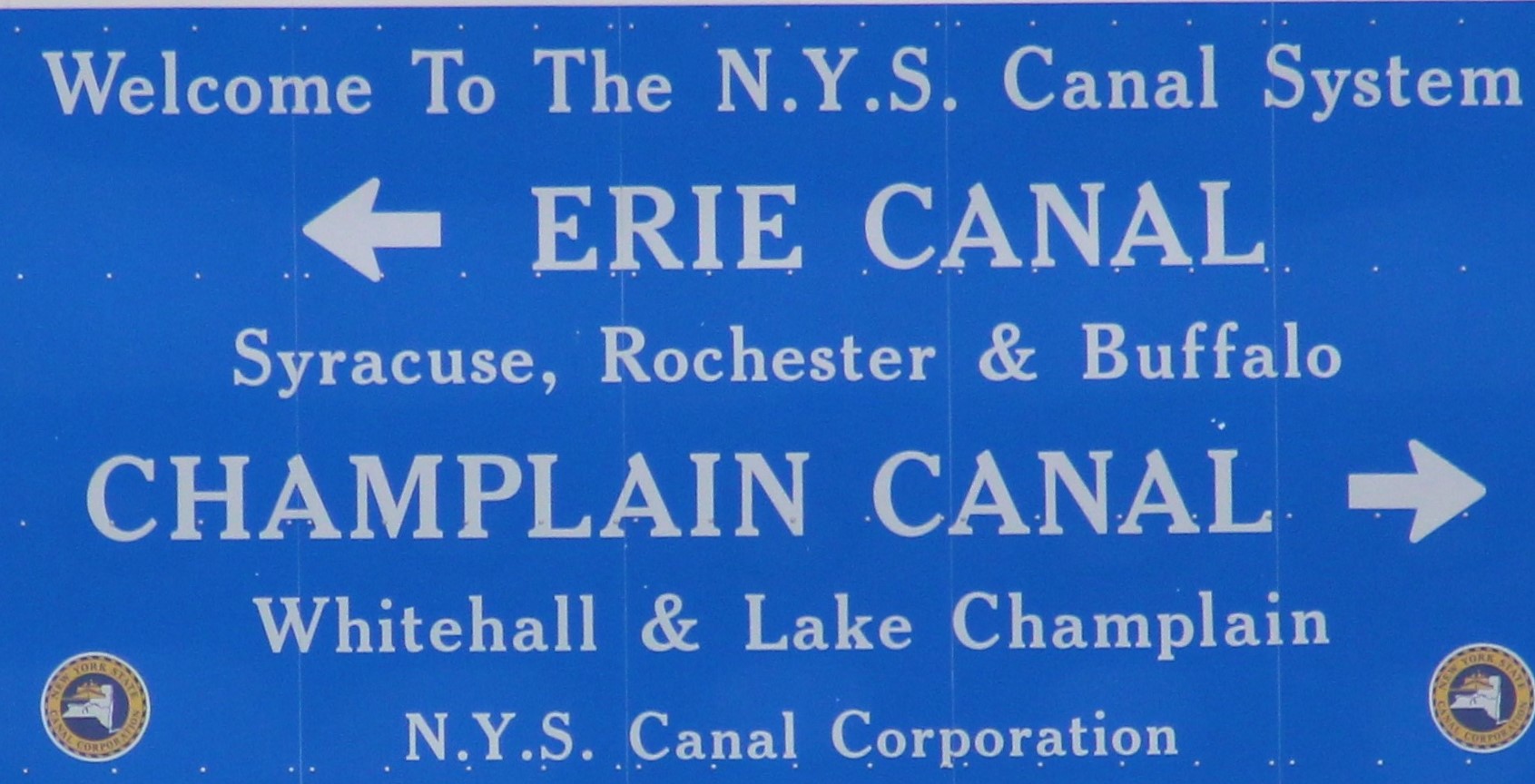
    Tune in next week to see which way the crew decides to go. 

    Henry Hudson


  • Whale of a Tail

    Hello virtual crew members and fellow adventurers!

    Eric here reporting on our crew’s journey from Cape May, New Jersey to 37 miles north of New York City at Croton on Hudson, New York.

    But first another welcome aboard is in order for our newest virtual crew member, Russ Kunkel.

    If you would like to be a virtual crew member for this adventure, go to the website https:/stillwaters2scuttlebutt.com and click on the ‘Follow’ button in the lower right hand corner.

    Run Up New Jersey to New York City

    The run to New York City was made in three jumps:

    1. Cape May to Atlantic City via the ICW
    2. Atlantic City to Brielle via the Atlantic Ocean
    3. Brielle to New York City via the Atlantic Ocean
    IMG_1809
    King Neptune guarding the marina


    On the first jump, the crew decided to make the run up the Jersey ICW rather than make the run outside on the big pond.  The wind conditions were predicted to cause 3-5 foot seas that the crew wanted to avoid.

    However, the risk of running on the inside via the ICW is going aground.  The Jersey ICW has a bad reputation for being shallow and narrow.  Local knowledge suggests that a crew should start two hours after low tide to ensure the most water on the day run to Atlantic City.

    Unfortunately for our crew, they needed to take on fuel before leaving the marina.  This caused the crew to shove off at 0845, only 30 minutes before high tide.  The first half of the day was uneventful, but as low tide approached at 1500, the skipper was constantly challenged to keep 4 feet of water under the boat.  Between 1400 -1700, the crew found less than 4 feet of water at least three times.  Each time the skipper was able to stop the boat and back up before going aground.

    In this same time frame the crew actually saw one boat stuck aground.  A second boat was heard hailing Boat US Tow Service because they had run aground.

    All in all, it was a long nervous day for the crew as they navigated the shallow waters.  I overheard the skipper tell the Admiral that he was adding this run to his ever growing list of things he is never going to do again.

    Shore Excursions in Atlantic City

    • Atlantic City Aquarium
    220px-Trachinotus_falcatus[1]
    Permit

    The aquarium had a nice display of Mid-Atlantic Fish.  The aquarium had Permit on display.  You do not often see these fish at aquariums.  The Permit holds a special place in the heart of the skipper because it was the namesake for the boat he served aboard during his Navy days, the USS Permit SSN-594.

    0859416b[1]

    This pic taken in 1984 San Francisco Bay while she was going out on sea trials. You can see the Golden Gate Bridge in the background.  The skipper was standing watch as Engine Room Supervisor when this pic was taken.


    Absecon Light House

    IMG_1866


    The skipper and Admiral walked to the Lighthouse and then made the 228 steps to the top of the lighthouse to view the surrounding area.  The Lighthouse was placed in operation in 1857.  She is New Jersey’s tallest lighthouse at 171 feet tall.  She is the third tallest masonry lighthouse in the US.

    IMG_1826
    Webcam of skipper at the top of Absecon


    • Atlantic City Boardwalk
    IMG_1870
    Boardwalk near New Hampshire Ave


    If you have ever played the game of Monopoly, you know that the most treasured piece of property is Boardwalk.  The next most treasured property is Park Place, which turned out to be a small road leading to the Bally’s Casino off of Pacific Avenue.

    IMG_1586
    Atlantic City at night


    The crew had fun as they walked the iconic boardwalk from the north end starting at New Hampshire Avenue down to Iowa Avenue.  They even stopped at Texas Avenue for a break.  For a Monday afternoon there were already plenty of people out enjoying the day.  Many of the businesses were still closed however, with their openings scheduled for Memorial Day Weekend.

    On the second jump, Tuesday May 24, 2016, the crew decided to run outside to Manasquan Inlet.  After leaving the Absecon Inlet, the crew turned north and headed up the Jersey coast running about three miles off shore. The swells were about four feet with a period of 8 seconds, which means there was a 4 foot swell about every 8 seconds.  As the day wore on the swells lessoned to two feet which made for a nice cruise.

    IMG_1595
    Whale off the bow


    Around Little Egg Inlet, the skipper spotted his first whale.  Before the day was out the crew had spotted five whales.  One of them surfaced about 10 yards just off the port side of the boat.

    On the third jump, to NYC, a boat most run on the outside because the ICW ends at the Manasquan Inlet. The ocean swells were 2-3 feet with a period of about 7 seconds. This made for rolling seas all the way to NYC.

    IMG_9304
    Still Waters II approaching the Verrazano Narrows Bridge.  Entering the Upper Hudson Bay.


    Upon arriving in the Sandy Hook big ship channel, the skipper noticed that the Cat Daddy had caught up with Still Waters II and was following in her wake.  The two skippers agreed to continue on to Lady Liberty together and take pics at the statue.

    IMG_9319
    Still Waters II at the Statue of Liberty


    After the photo shoot, the vessels made their way behind Lady Liberty and anchored.  Rafe Williams, Cat Daddy’s captain, made the dinghy ride over to Still Waters II, and an enjoyable evening was had by all swapping recent sea stories.

    IMG_1952
    Cat Daddy joins the crew


    About 0915 the crew was surprised by a 15 minute fireworks show on Liberty Island.  Must be part of the Fleet Week activities going on throughout the city for Memorial Day Weekend.

    Shore Excursions in New York City

    The skipper awoke to almost completely discharged batteries the next morning.  He started the generator and charged the batteries for two hours so he could start the engines.  After the engines were started the crew made the one hour hop over to Lady Liberty Marina.  Unfortunately, when the crew arrived they were informed that a transformer had failed nearby and taken all the power in the area down.  Interesting, must be a day for electrical gremlins to run loose.

    911 Memorial

    • 9/11 Memorial

    The crew settled the boat and hooked up shore power with the hopes that the power would be restored while they were out exploring.  They took a ferry over to Lower Manhattan and then walked to the 9/11 Memorial.  Just so happened that their visit fell on the 15th anniversary of completing the cleanup following the attacks.  The construction workers, police, fire, and survivors were present for a remembrance celebration in the Museum.

    • Ellis Island
    Central RR NJ Terminal
    Central RR Station where the ferries pick up today, but the immigrants caught trains to their new lives


    The crew took the Statue Cruise Ferry to Ellis Island and spent about 4 hours exploring the museum.  The restoration of the facility was well done and the museum does a good job of discussing immigration to the United States, pre and post Ellis Island.

    IMG_2008
    Showing immigration routes on a globe


    One interesting observation the skipper made was the change in the facial expressions in the exhibit.  You could see the tension build as the new immigrants made their way to Ellis Island.  Then the facial features were really strained as they waited and processed through the facility.  However, once they made it, you could see the stress was gone and a big smile adorned their faces.

    Another interesting story told was that the immigrants needed 25 dollars to enter the country.  A running joke was that with the thousands of people who processed through the facility each day, that there was actually only 25 dollars on the island.  The new immigrant would pass the money back to next family in line after proving that they had 25 dollars.

    There are many first-hand accounts of actual immigrants explaining their story as they moved from their home country to the US.  Makes for a very moving experience to walk back in time and share their hope for a better life.

    IMG_1637
    One of skippers favorite stories


    • Liberty Island
    IMG_1640
    Selfie madness in the back ground as people take pics with Lady Liberty


    The crew spent so much time on Ellis Island that they only had an hour to wander around Liberty Island.  One new tidbit the skipper learned was that Gustave Eiffel, of Eifel Tower fame, designed the internal support framework of Lady Liberty.

    IMG_1641
    Ferry ride back to marina


    Symbolism abounds on the Statue:

    Torch: The torch is the strongest symbol that Bartholdi incorporated into the Statue. In fact the Statue’s real name reflects its true meaning: “Liberty Enlightening the World”.

    Crown: The statue wears a crown with seven spikes. This represents the 7 seas and 7 continents of the world, re-enforcing the universal concept of liberty.

    Tablet: The Statue holds a tablet in her left hand. It is a book of law based on the founding principles of this nation, a nation based on law.

    Writing on the Tablet: The Statue’s tablet contains writing on it. This was one of the last changes that Bartholdi made to the Statue. It was originally left blank. Bartholdi placed the date of America’s independence on the tablet (JULY IV MDCCLXXVI ). They are in roman numerals which are symbolic of law.

    Shape of the Tablet: keystone – In architecture, a keystone is the stone which keeps the others together. Without it everything would fall apart. The keystone of this nation is the fact that it is based on law. Without law, freedom and democracy would not prevail.

    Sandals: The Statue of Liberty actually wears sandals. She is also not standing still. Even though the Statue stands on a pedestal, she is actually walking ahead moving forward. This goddess is lighting the path to freedom through peace, not violence. Her footwear also suggests her stature as a free person.

    Robe: The Statue of Liberty wears a free-flowing robe or stola, which powerfully refers to the Roman influence of the goddess “Libertas”, which was worshipped by freed slaves.

    Chains: Located at the Statue’s feet symbolize the freedom that Lady Liberty has. It demonstrates that the Statue is free from slavery and bondage.

    Shields: Richard Morris Hunt made some representations in his pedestal design as well. He placed shields on each side of the pedestal symbolizing the states in the Union.

    Granite Brick: There are 13 layers of granite that comprise the body of the pedestal. The 13 colonies formed America in 1776.

    Run up the Hudson River

    Manhatten at Nite
    View from the marina


    You probably guessed it, but after being missing for 405 years, the skipper has found Henry Hudson.  You might recall from your history lessons that mutineers placed Henry, his son, and 7 others in a small boat in 1611.  The small crew was never seen again.  But who better to narrate our voyage up the Hudson than Henry himself.  I will catch back up with you when you get to Troy, NY.  Eric the Red

    I first cruised these waters back in 1609 looking for the rumored Northwest Passage.  My crew spent ten days exploring this river that now carries my name.  We made it as far as present day Albany.

    George Washington Bridge
    George Washington Bridge


    One thing has certainly changed since the last time I was here.  These shores are now covered with buildings where thick forests once stood.  And those huge bridges crossing the river were not here last time either.

    Grants Tomb
    Grant’s Tomb


    Before the crew got out of the upper Hudson Bay and actually started up the river they passed an interesting scene.  The NYPD and Coast Guard had created a boundary area around a plane that crashed in the river the day before.  A rescue vessel was present with divers in the water who were attaching lifting devices to the plane.

    Also, the crew managed to land in NYC for Fleet Week.  Because of this, the marinas were booked for the weekend and our crew had no place to stay.  They shoved off from the marina and travelled 37 miles north, where the crew stopped at one of the spots I anchored in back in September, 1609.   The crew stopped at Half Moon Bay Marina.  The marina is named after my ship that sailed these waters back in 1609.

    HMB Marina
    Half Moon Bay


    In the coming week, the crew will head further up the Hudson River Tuesday morning to Poughkeepsie where they have planned shore excursions to the FDR home at Hyde Park, Culinary Institute of America, and Vanderbilt Mansion.

    Check back next week as we continue our epic journey around the Great Loop.

    Henry Hudson

  • Splish, Splash, She is Taking a Bath

    Hello virtual crew members and fellow adventurers!

    Eric here reporting on our crew’s stay at Delaware City.

    I would first like to welcome Dave & Teresa Sammons as our newest virtual crew members.  They are longtime friends of the crew.  Welcome Aboard!

    The crew went exploring around town on Sunday and Monday.  The town’s history is closely tied to the Chesapeake and Delaware (C&D) Canal.

    Canddmap

    The construction of the original canal began in 1804 with a goal to shorten the travel route from Philadelphia to Baltimore.  The plan included 14 locks to connect the Christina River in Delaware with the Elk River at Welch Point, Maryland.  The project was put on hold after the company ran out of funds.

    The canal company got reorganized in 1822 with a new route from Newbold’s Landing Harbor (now Delaware City) to the Elk River.  The new plan called for only four locks.  Work restarted in April 1824.

    The workers used picks and shovels to dig the 14 mile canal, 10 feet deep and 66 feet wide.  Workers were paid about 0.75 cents a day for this back breaking labor.  The workers completed their task and the canal opened for business in 1829.


    IMG_1571
    Portion of the original canal in Delaware City


    Initially teams of horses and mules pulled the barges through the canal.  Later steam engines replaced sail power which required a larger canal.  Eventually, the pressure from the railroads caused canal traffic to decrease and put pressure on profits.

    In 1919, the federal government purchased the canal and turned operation over to the US Core of Engineers.  In 1926, the Core completed renovations of the canal that moved the eastern entrance from Delaware City to Reedy Point, approximately 2 miles south.  The new canal was 12 feet deep and 90 feet wide and ‘free’ to commercial traffic.

    Between 1936 and 1938, the canal was altered again.  The depth was changed to 27 feet and the width was 250 feet.  By the mid 1970’s, the canal was 35 feet deep and 450 wide.

    Chesapeake_and_Delaware_Canal_eastern_entrance
    A look down the canal today


    On Tuesday, the crew got a bit of a surprise as the schedule for the haul out changed.  Quest, a, Canadian vessel, was scheduled to be hauled out first at 0700 to have her props changed.  However, her props had not arrived and were not scheduled to show up until 0830.  The marina decided to haul Still Waters II first, then haul Quest.

    IMG_1569

    I would show you pictures of the garbage that came out of the water tangled around the props, but no pictures are available because somehow the skipper has misplaced the camera and cannot find the device.  He thinks he left the camera in the vehicle that picked him up to rent a car.  However, seems nobody has seen the camera in the vehicle.

    Anyhow, the starboard prop looked like a big ball of sail material had wrapped itself around the prop.  On the port side, the sail lines had wrapped themselves around the shaft.  Not sure where that junk would have come from other than sucked up off the bottom of the marina in Havre de Grace.

    IMG_1570
    Outside Crabby Dick’s Restaurant.


    The crew went ahead with their plans to have the props removed and rebalanced.  While they were at it, they had the two spare props stored in the bow reconditioned also.

    The Baltimore prop shop was unable to do the work because they had two 80 inch props in their shop that they had to get turned around by the end of the week.  The marina ended up sending the Still Waters II props down to Cambridge, MD.

    IMG_1756
    Served the best burger ever.  Short rib, brisket, and sirloin all ground together.


    The shop completed the work and the props were back installed on the boat by close of business on Thursday.  All was set for an early splash on Friday morning.

    IMG_1573
    New wheel on the port side.


    The Admiral went to return the rental car and make one last attempt to recover the camera, while the skipper went to the marina to launch the boat.  When the Admiral arrived without the camera at around 0930, the boat was still on the hard.  The launch did not take place until about 1030 due to low tide and current.

    When she was finally splashed back in the water the engines decided that they would not start.  Troubleshooting found the batteries were down to 9 volts, so the marina manually shoved the boat out the chute and tied her to the dock to charge her batteries.

    The crew finally shoved off the dock to make the run to Cape May at about 1400.  Since this was a long run and a chance to run out of day light before docking, the skipper ran the boat at 12 mph to make the Cape May inlet at 1830.  They then made the three miles in the canal to Utsch’s Marina and were safely tied to the dock by 1920.  Thanks to the young man on the sailboat from Rhode Island in the next slip for the help with the lines.

    IMG_1789
    Launching a sailboat while in tight quarters


    The decision to make the run to Cape May turned out to be a good one because overnight a big storm blew in with sustained winds over 20 mph.  Delaware City had no room to dock Saturday night, so the crew would have had to find another place to move to in the wicked weather.  Instead our crew is safe and sound in Cape May making plans for the jump up the New Jersey coast to New York City.

    image
    Salem Hope Creek Nuclear Power Plant on the Delaware River


    Check in next week to see if the weather will allow an outside run to Atlantic City or will the crew take the Jersey ICW.  Will the anchor hold next to Lady Liberty in the New York Harbor?  Lastly, shore excursions planned to Ellis Island, Statue of Liberty, and the 9/11 Memorial.

    image
    Ship Johns Shoal Lighthouse in Delaware Bay


    Till then, may the wind be at your back and the seas calm ahead.

    Eric the Red

  • Wrath of the Three Sisters

    Hello virtual crew members and fellow adventurers!

    I would like to welcome mirmal@…. aboard as our latest virtual crew member.  Welcome aboard!

    Eric here reporting on our crew’s wanderings and whereabouts in the Chesapeake Bay.


    After arriving at Yorktown on Friday, May 6th, the crew spent Saturday on the back of the sundeck listening to three different bands play the blues.  The Blues, Brews, and BBQ Festival wrapped up at 1800 so the crew went back to Ben & Jerry’s for more ice cream.  They then walked the waterfront of old Yorktown to read the historical markers along the path.  A couple of the favorites:

    You can click on the pic to enlarge and read the markers.

    The skipper also managed to work in a repair of that pesky ‘lower switch’ on the anchor.  He had a new switch delivered to Norfolk.  The new switch had a rubber cap to prevent water intrusion into the body of the switch.  After removing the old switch, the skipper was able to clean the spring and operating cylinder so the switch does not stick anymore.  The skipper installed the repaired switch with the new rubber cap.  We will see how long the repair holds up.  Especially since the crew will be anchoring out several nights in a row after leaving Yorktown.

    The run up the Chesapeake to Smith Point was more than exciting.  The day started fairly routine with calm waters greeting the crew.  However, as the day progressed the weather worsened to the point to make this the roughest day on the water yet.  The weather report was for winds out of the northwest which should have provided protection as the crew voyaged north.  However, about 1300 it got eerily calm.  Then you could see ripples building on the water to the North.  Then the winds decided to pick up steam.  The skipper estimated the winds at 15-20 mph.  This caused some serious wave action.

    At first the waves built to 2-3 feet, then 3-5 feet.  The problem with that is that every once in a while the crew got 7-10 foot waves.  In fact, water crashed over the top of the bow pulpit three times as Still Waters II cut through the waves.  That was a first for the crew.  The ships bell seemed to be ringing constantly due to the up and down movement of the boat riding over the waves.

    Old Salts call this phenomena of large rogue waves the “three sisters” because the larger than average waves seem to travel in sets of threes.  The skipper could see the large waves coming and the boat took the first one pretty well.  The second sister then arrived and lifted the bow high, high, high into the sky.  The boat then crashed down in the trough between the second and third wave.  The water then came crashing over the bow.  The crew spent about 2.5 hours in this mess before the conditions began to lighten up as the crew finally approached land at Smith Point.

    The other thing that happened during this period was the loss of the dinghy.  Somehow the bow of the dinghy came off of the support davit while the back of the dinghy was still on the swim platform davit.  The Admiral took the helm so the skipper could go out on the swim platform and try to rescue the dinghy.  Several times the water came about knee deep on the skipper while he clung to the swim ladder with one hand and wrestled with the dinghy with the other hand.  The bottom line is the crew lost their second dinghy.  You might recall the loss of the first dingy in the Pamlico Sound in 2015.  The skipper called the Coast Guard to report the dinghy adrift and that the seas were too bad to try and recover the dinghy.  The Coast Guard called the following day and reported that the dinghy had been spotted 16 miles down the bay from where it came off the swim platform.  So the score is now: dinghy 2, skipper 0.

    IMG_0058, Point Smith Light
    Smith Point Light on Monday after round two of dinghy wars


    After making it to Smith Point, the crew entered a narrow channel and anchored in the protected Ellyson Creek.  The crew was amazed at how calm the creek was while just outside there was still chaos.

    IMG_0045, Smith Point Ellyson Creek
    The calm of Ellyson Creek


    Things went much better for our crew the next day on their run to Tilghman Island where they anchored in Dun Cove.  Other than the rain that followed them most of the day, this was an uneventful run.

    IMG_0048, Leaving Smith Point, Looking 12 miles across Potomac River
    Leaving Ellyson Creek.  Looking across the 12 mile mouth of the Potomac River


    With the cloud cover and rain it was hard to see much of the surrounding area.  The skipper did point out though when they passed Calvert Cliff Nuclear Power Station.  He just cannot let it go.

    IMG_0047, Waterman catch
    Boat load of fish.  These guys were coming in the creek while Still Waters II was leaving.

    They did pass several old lights that have been basically abandoned in place.  These lights make for good landmarks to target while traversing the Bay.  Unlike the day markers and buoys, the lights can be seen for miles.

    Point No Point Lighthouse


    The crew had a peaceful night’s rest until about 0430 in the morning.  Then the Bay Watermen were out in force checking their lines and crab pots.  They kept waking the boat as they passed so the skipper went ahead and got up at 0515 to prepare for the day’s cruise.

    It was an uneventful day with one surprise though.  During the mid-day engine room checks, the skipper noticed a bundle of wires had fallen and were rubbing on the port engine shaft.  The skipper made a temporary repair while underway.  Once docked the skipper made a permanent fix.  One blue twisted strand wire had worn thru the insulation and most of the twisted wires had been eaten through also.  The skipper is not sure what that little blue wire feeds, but he is glad it got fixed before something failed.

    IMG_0062
    Waterman’s Crab House

    After docking at the Waterman’s Crab House, the crew walked the small town of Rock Hall down as they went to the grocery store.  Let’s just say it is not your neighborhood HEB.  But the crew did find the essentials.  The skipper got cokes and cookie dough, while the Admiral was a little more practical and got milk, cheese, and bread.  The sun did finally make a showing in the evening so the crew walked out to watch the sun set over Baltimore.

    IMG_0067, sunset over Baltimore
    Looking across the Bay towards Baltimore


    The next morning the weather was calm with little to no current so the skipper took some time to give the Admiral docking practice.  The Admiral backed the boat away from the dock and then maneuvered back to the dock where the skipper secured the boat to the pier.  They untied and shoved off again.  The Admiral then once again successfully maneuvered the boat to complete her second dock exercise.  The crew then shoved off the last time and headed to Havre de Grace in the northern reaches of the Bay.

    IMG_0022
    The Susquehanna River provides over half of the fresh water to the Bay.

    The crew spent about 5.5 hours cruising over to Havre de Grace.  The wind was perfect for a calm day on the water.  The north end of the Chesapeake is very picturesque.  Just as the crew completed securing the vessel to the dock and getting the shore power and water hooked up, a big rain storm started.  Timing is everything.

    IMG_0008 (1)
    Concord Point Light – Oldest continuously operated lighthouse in Maryland


    The skipper found the history of this little town very interesting.  For starters, General Lafayette inspired the name of the town when he commented that the town reminded him of Le Havre, France.  When the town incorporated in 1785, they named the new town Havre de Grace.

    IMG_0041

    Secondly, in 1789, Havre de Grace, almost became the nation’s capital.  The First Congress selected the town as the nation’s capital, but did not officially vote and make the selection binding.  During the next session of Congress, the southern states would not back the location due to it being too far north.  The southern states were now working to locate the new capital further south.

    The northern states were also trying to pass a law where the Federal Government would pay off the states war debts.  The southern states had less debt than the northern states so they did not support the bill.  A compromise was finally reached where the northern states agreed to move the capital further south, and the southern states agreed to pay off portions of the northern war debt.  In 1790, Congress passed the Residence Act which sited the new capital along the Potomac River.  The Act allowed the sitting President, George Washington, to make the final selection of where on the Potomac.  Is it a wonder that George picked an area just upstream of his home at Mount Vernon?

    IMG_0020 (1)
    Town hero fired this cannon against the British


    Third, During the War of 1812, the British invaded and basically burned the town to the ground on May 3, 1813.  One man, John O’Neil, manned a cannon and began firing on the British.  The 400 British soldiers returned fire, finally landed, and captured O’Neil.  His daughter, Matilda, at the age of 15 went to the British Admiral George Cockburn and negotiated her father’s release.  The Admiral was so impressed by the young girl’s courage, he also gave her a gold snuff box.

    IMG_0044
    John O’Neill built this house in 1822 as a wedding present for his daughter


    The town rebuilt and there are now many homes still occupied that date back to the 1830’s.  There are actually two homes in town that have been occupied by the same family since they were built in the 1800’s.  They are now in the fifth generation of family ownership and occupancy.

    IMG_0031
    On the side of an old house on Market Street


    The Lafayette Trail is a three mile, self-guided tour that takes you around 57 historical landmarks in town.  All you have to do is follow the Blue Line that is painted on the sidewalk.  You can see pics and read about all 57 stops on the trail by clicking on the Lafayette Trail Link.  If you take the virtual tour, look for the blue balloon at the top of the map, it is stop number 1.  All other balloons are red.  I invite you to review the historic buildings and post a comment on your top three.

    Click to begin.

    The skipper’s top three were:

    1. #1 Lock House – Home of the lock tender
    2. #41 Concord Point Lighthouse – the oldest continuously operating lighthouse
    3. #50 Rodger’s House -1787- oldest building in town, George Washington made several stops here in 1787 and 1795

    One stop that was not on the historic trail but was the skipper’s favorite stop in town was at Bomboy’s Ice Cream and Candy Store.  They advertise, “You are what you eat, so eat sweets.”  Now that is a motto that the skipper can get behind.

    IMG_0029 (1)

    On Saturday, May 14, the plan was to cross through the Chesapeake and Delaware Canal.  Then anchor in the Salem River to wait for good weather to make the run to Cape May, N.J.  The weather forecast calls for winds near 20 mph with gusts greater than 25 for Sunday and Monday.

    However, Still Waters II decided she wanted to go to Delaware City.  The starboard main engine has had a vibration issue since the boat was purchased by the crew.  They knew that eventually they would need to repair the prop and cutlass bearing.  Well the time and place is now.  Over the last three runs the vibration has become a little worse each time.

    The crew has decided to have her hauled out, props reconditioned, cutlass bearings replaced, and splash back in the water on Friday, May 20.

    In the mean time, the crew will do shore excursions in and around Delaware City.  The first thing the skipper learned about Delaware that he likes, is that the price you see is the price you pay.  Delaware has no sales tax.

    IMG_0034

    But before fun and games can begin, the skipper needs to find a place to stay for a few days while the marina works on the boat.  Check in next week to see if the schedule holds and the splash happens on Friday so the crew can get back underway.

    IMG_0055
    The crew will get their ducks in a row and hopefully set off at the end of the week.  Yes I know, these are geese but I bet you get the point.  These little guys were at the Lock House in Havre de Grace.


    Till then, may the wind be at your back and the seas calm ahead.

    Eric the Red

  • It Is A Small World

    Hello virtual crew members and fellow adventurers!

    Eric here reporting on our crew’s attendance at the AGLCA Spring Rendezvous in Norfolk, Va.  In 2015, you might recall, the crew only met one couple from Texas, and the couple had lived in Arlington, Texas.

    This year, there were six couples from Texas, and 25% of them had lived in Arlington, Texas.  In case you did not know, our skipper was born and raised in Arlington.  Rafe  lived in Arlington as a child and moved from Little Road to Boyd, Texas before Junior High.  He also graduated from High School in 1978, same as our skipper.

    IMG_0011
    Rafe’s  Cat


    Lynn attended The University of Texas at Arlington earning her degree and eventually taking a job in Austin, Texas.  Speaking of Austin, two of the boats hailed from Austin, Texas.

    IMG_0010
    Lynn is what is known as a reluctant spouse for this journey, hence the name of the boat, Lerry Lynn.  However, she now loves being on board for three years and counting.


    The two other Texas boaters hailed from Blanco, TX and Porter, TX.  Can you spot the Star Trek fan?

    The crew spent most of their time sitting in presentations and learning more about navigating the Great Loop.  I will not bore you with the details of the seminar, but our crew definitely learned more about the adventure that lies ahead and is itching to get to New York City and beyond.

    IMG_0009

    The crew also finally got to meet Joe and Pam of Tasteful Traveler.  Still Waters II spent most of 2015 following in the wake of Tasteful Traveler, but the two crews never crossed paths and actually met.

    The Looper Crawl was a huge success for the Admiral.  The crew showed Still Waters II during all three Looper Crawls.  The Admiral got many compliments from the folks who came aboard.  Several people came back each day to look at her again and take away some of the Admiral’s decorating ideas.  One lady even commented that the Admiral should start a Boat Decorating Business and help others finish out the interior spaces of their boats.

    Still Waters II turned out to be a popular spot for people to just hang out.  On Monday, the Looper Crawl officially closed at 1730, but she had people onboard all the way to 1900.  On Tuesday, a crowd gathered and finally dispersed about 2000 because they all decided to finally go find something to eat.  On Wednesday, another crowd gathered and broke up at 1900 so they could attend the seminar dinner.

    IMG_1654
    Skipper, Christy, Doyle, Rafe, and Patsy


    On Wednesday night, the crew went down to Abaco Lady and joined Doyle and Christy who hosted a sing-a-long aboard their boat.  The skipper was encouraged by the gathering to join in and sing.  He informed them that he was tone deaf and a prison singer – you know – always behind a few bars and never has the right key.  The crowd allowed him to just stay and watch.

    IMG_1659

    On Thursday afternoon the crew said good bye to another couple, Thad and Cindy, aboard Glorious Dei.  I suspect there will be many more meetings between these two in the days and months ahead because the Admirals have really hit it off.  In fact they have made some kind of pact together.  We will have to wait and see what comes of that.

    Our crew left Friday morning in the rain after some of the other boats cleared out of the marina.  First destination was  Yorktown to attend the Blues, Brew, and BBQ festival.  The rain followed the crew most of the day but cleared long enough to get docked.  However, they were surprised to find the Hokule’a  at the Riverdale Landing in Yorktown.

    IMG_0030

    Hokule’a left Hawaii in 2013 to circumnavigate the globe.  The crew got to board and tour the vessel.  The skipper asked what the worst seas that they had encountered.  A crew member reported a stretch in the Indian Ocean where they had 20 foot swells.  The skipper thinks he will skip any passage on the Hokule’a.

    IMG_0037.JPG
    Still Waters II in the background of Hokule’a


  • The Good Old North State

    Hello virtual crew members and fellow adventurers!

    Eric here reporting on the travels of our crew after leaving Barefoot Landing Marina and making their way across the state of North Carolina and part of Virginia.

    But first one funny story about the good fortune of the skipper while at Barefoot Landing.  You may recall that our skipper has a liking to ice cream and he is on a mission to test as many ice creameries as possible while on this adventure.


    IMG_0022
    Someone living off the grid.  No external power.  Rain barrels for fresh water.


    When he arrived at his favorite Barefoot Landing ice cream store there must have been 25-30 people jammed in line at the store.  He noticed that the servers were not serving and that someone was on the phone trying to troubleshoot the cash register.  Seems they had lost their internet connection so they could not charge the customer transactions.  (Do you see the irony in calling this machine a cash register?)

    After about a five minute wait with no activity, the server on the phone hung up and announced that the ‘cash’ register was broke and that they could not accept credit cards, only cash.  Darn the bad luck, almost everyone cleared out of the store and left the skipper third in line behind two other older gentlemen.  One of the three reached in his pocket and pulled out some cash and showed it to the leaving crowd.  Needless to say they were not impressed.  The three had a good laugh as the young folks left the store moaning and complaining.  The skipper placed his order and paid cash at the cash register, what a novel idea.

    Crossing North Carolina

    Day 1, Sunday, April 24, 2016, The crew left Barefoot Landing about 0930.  As they travelled up the river they noticed more and more local boaters getting on the water.  The skipper was aware of an inlet not too far away and began to wonder if most of these folks were headed out into the Atlantic.  The skipper reviewed the weather and wave forecasts and proposed that they travel up to Southport on the outside, i.e. Atlantic Ocean.

    After a little discussion the crew decided to go out the inlet and run on the outside as long as the forecasts were correct about the wave size.  When they arrived the Atlantic looked good so they proceeded out into the Big Pond.  They ran East three miles off of the coast for some 25 miles and then came back in at the Cape Fear Inlet.

    IMG_0012
    Coming back in at Bald Head Island


    After getting back on the ICW they anchored out in the Bay at mile 305.

    Day 2, Monday, April 25, 2016, The crew weighed anchor and headed north on the Cape Fear River at 0801.  The Cape Fear River does not seem as scary to the skipper as the movie made it out to be.  Actually very calm and serene.

    Every day presents new challenges to overcome and today that challenge will be to make bridge openings on time.  Several bridges through this section only open on the hour.  Miss the opening and you have to wait for the next opening.

    IMG_0004 (2)
    Kite surfing the Bogue River


    The skipper timed the Wrightsville Beach Bridge just about right.  Only had to wait for 15 minutes to pass through.  There was a funny exchange between the skipper and the Bridge Tender though.  The charts show the bridge to be 22 feet.  Still Waters II air clearance is 17.5 feet.  The skipper was looking for the clearance markers on the bridge to verify he could go under, but could not see them.  He hailed the tender and asked for the current clearance.  The Bridge Tender informed the skipper that there was only 15 feet of clearance. He also suggested the skipper wait for the bridge to open.

    The Figure 8 Island Bridge had 22 feet of clearance when the crew arrived so they did not have to wait.  However, they arrived 30 minutes early for the 1400 Surf City Swing Bridge Opening.

    The crew caught a break though because a commercial Ferry was headed south so the Bridge Tender opened the Bridge early and allowed Still Waters II to pass.  Not bad, only 20 minutes of waiting this year.  Beats the hour wait from last year when the bridge Tender closed the bridge just before the crew was about to pass because so many boats were in line and car traffic really got stacked up.

    IMG_0040

    At about 1450, a powered catamaran passed Still Waters II.  Her name was ‘Next Adventure’ and she was flying a white AGLCA burgee.  When the crew approached Mile Hammock Bay to drop anchor, they noticed that ‘Next Adventure’ was already swinging on the anchor.  The skipper dropped anchor next to “Next Adventure.”

    In a little while the skipper noticed that someone in a dinghy was rowing over to Still Waters II.  It was the captain of ‘Next Adventure”.  Tom Hoffmann rowed over to swap boat cards with our crew.  Tom retired after 31 years at the Kennedy Space Center.

    IMG_1541
    How to borrow a cup of sugar from your neighbor


    Day 3, Tuesday, April 26, 2016, Three unusual events unfolded as the day progressed.

    The crew pulled the anchor at 0815 and headed north through Camp Lejeune.  They arrived at the Onslow Beach Swing Bridge at 0847.  While waiting for the 0900 opening, a crimson boat arrived at a high rate of speed.  The captain radioed the skipper and asked his cruising speed.  The skipper answered, “Usually 6-8 knots.  The captain then asked if he could pass them prior to the bridge opening.  The skipper maneuvered Still Waters II off to the side and then behind the crimson boat.  As the Swing Bridge began to rotate the crimson boat started forward and by the time the boat was between the fenders of the bridge he was throwing a huge wake.  So much for the No Wake sign hanging in plain view.

    The skipper let that die down a little bit before he went through the bridge at idle speed.  He commented to the Admiral that that guy must be in a big hurry.  Not to long after that another person came on the radio and said that he was pulling back on the throttles and asked the red boat for a slow pass.  Obviously that did not happen because the next thing you here on the radio is “Thanks for the @#%$^ slow pass and huge wake.”

    Then a little later, the crew heard the marinas in Swansborro hailing the red boat and telling him to slow down because he was in a posted No Wake Zone passing by town.  Again, he ignored them and was met with some sarcastic thank you’s.

    The next strange thing that happened today was a report of a sailboat wrecking into the fenders at the Beaufort Bridge.  A sailboat captain hailed the Coast Guard and asked to go to Channel 22A.  The skipper decided to listen in and also went to 22A.  The sailboat captain reported that another sailboat, ‘Evergreen’ had come within 20 feet of colliding with him as they approached the bridge and then ‘Evergreen’ actually collided with the bridge fenders.

    IMG_1549
    That had to hurt.


    The Coast Guard sent a boat out to find ‘Evergreen’ and then had them return to port for a safety vessel inspection.  The skipper suspects they got some other type of inspection also.  Something about walking a line and touching your nose.

    When the crew passed under the bridge about 45 minutes later, you could see the damage to the fenders.  If the bridge fenders look that bad, I would hate to see the damage to the 40 foot fiberglass sailboat.

    The final creepy event occurred after dropping anchor up in Cedar Creek. A few hours after dropping the anchor, the Admiral looked out the window and commented that it looked like the boat had moved.  The skipper jumped up and looked out, and sure enough the anchor had let loose and the boat was drifting to shore.  She was only 30 yards or so from the bank.

    IMG_0007 (1), sunset Adams Creek
    At least the view is good from Cedar Creek


    The skipper got the depth finder turned on and determined they had 5 feet of water under the boat so he started both engines.  The Admiral hustled out to the bow and began retrieving the anchor.  With the anchor up, the skipper moved the boat back to the leeward shore and they dropped the anchor again.  This time they let out 150 feet of chain in 5-6 feet of water.  That should hold them tight for the night.

    Never a dull moment on Still Waters II.  Needless to say the skipper did not sleep well as he monitored the anchor every other hour.

    Day 4, Wednesday, April 27, 2016,

    The challenge over the next several days will be the weather.  More specifically, the wind speed and direction.  Still Waters II will be passing through some large bodies of water that can get nasty with strong winds.  However, by the look of today’s weather forecast, the crew should have favorable conditions most of the day.

    The cruise turned out to be pretty good due to the favorable winds.  The winds were normally blowing from the stern of the boat causing 2 foot rolling waves.  Still Waters II handles these just fine.  There was about twenty minutes though that they took the waves directly on the port beam and this caused some rocking motion as each wave passed under the boat.  Hope you did not get sea sick Teddy Paul.  It was only twenty minutes.

    IMG_0030
    Harvesting Oysters


    The crew made good time and arrived in Belhaven to dock at the River Forest Marina.  The winds were building as they approached the marina and the skipper backed the boat into the wind.  The Admiral and Eddie, the dock hand, did a great job of getting the boat secured to the dock.

    IMG_0010 (3)
    Never know what is coming around the next bend


    There were four other Looper boats in the marina.  The skipper talked to the Dock Master and learned that the boats had been there for three days waiting on a good weather window to leave and cross the Pungo River, Alligator River, and the Albemarle Sound.  These waters have a bad reputation.  The Dock Master said that the wind was supposed to die down over night.  The skipper hopes so, because it is howling at 20 mph at 2030.

    The skipper talked to a few of the other looper captains and seems no body is ready to commit to leave in the morning.  Our skipper looked at the weather and expects to leave in the morning with winds less than 10 mph.  Time will tell.

    Day 5, Thursday, April 28, 2016.  When the skipper woke and looked out, he noticed that one boat was already gone.  He noticed several others prepping to leave.  By 0700, there were only three boats left in the marina.  Our crew continued their morning routine and prepped to leave by 0900.

    A storm blew thru and after it passed our crew safely left the dock with one other boat.  ‘Triple Threats’ captain, decided to sit it out one more day before heading on to Norfolk.  The morning cruise was comfortable but the skipper was mulling over how to proceed.  Most of the other captains were all going to stop at the Alligator Marina, just south of the Albemarle Sound.  Sounded like a good plan B for our skipper but he desired to get across the Sound.

    IMG_0003, Aligator River
    Getting passed in the Alligator River


    The skipper decided to delay the decision of where to stop for the night and whether to cross the Sound until he actually got to the Alligator River Bridge.  Then decide based on weather conditions and time of day.  When they passed through the swing bridge the winds were in a favorable direction and there was plenty of daylight left to make it across the sound safely.

    IMG_0004, North River
    Sailboat in the North River


    The crew had an easy crossing in two foot waves and about 10 mph winds.  However, they still had 10 miles to navigate before they got to a good anchorage location.  After nine hours of cruising and 80 miles the crew dropped the anchor.  But while dropping the anchor the anchor lower switch stuck in the lower position.  The skipper had to turn the power off to the windlass to get the windlass to stop letting out chain.  This should make raising the anchor interesting in the morning.

    Day 6, Friday, April 29, 2016.  The skipper found a simple solution to the anchor issue.  The electrical connections for the switch are in the chain locker are easily disconnected. Does not solve the problem to disconnect the switch, but it did allow for the Admiral to raise the anchor in the cool misty rain this morning.

    Another day of timing three bridges and one lock.  Two of the bridges open on the hour and half hour while the lock and associated bridge only open on the hour.  Initial plan was to try and make it through the North Landing River and make the 1300 opening of the North Landing Bridge.  Even with the fog reducing visibility to less than 2 miles, the crew made the 1300 opening.  The skipper kept monitoring his progress and adjusting speed accordingly to make the bridge.

    IMG_0021
    Shrimper at work


    The Centerville Turnpike Bridge is 5 miles up the canal.  The skipper set the speed for 10 knots and arrived just in time to make it through the bridge for the 1330 opening.

    Now just 3.2 miles to the Great Bridge and Lock.  The skipper set the speed at 6 knots and they arrived a few minutes early to be in a group of four boats to pass through the lock.  Two of the boats had passed our crew earlier in the morning but missed the 1300 opening and had to wait an hour.  A crew member of one of the boats commented on the crew’s ability to time the bridge and lock just right.

    If the truth be known, the skipper has a little tool that helps him.  If you know the time of the bridge opening, and know the distance to the bridge, the little tool does the math and tells the skipper what speed to set the throttle.  Works every time.  The skipper loves math so he has fun checking the numbers for an on time arrival.

    IMG_0007
    Bald Head Eagle keeping an eye on the canal


    With the bridges and locks behind them, the crew pulled into Top Rack Marina to spend the night.  The marina offers a good deal for transient boaters.  If you spend $75 dollars in the restaurant, you get to dock for ‘free.’  The crew was stopping here because of the fuel prices, so might as well stay and celebrate completing the AICW, again.

    Day 7, Saturday, April 30, 2016.  The crew made the final 9 miles to the Waterside Marina in Norfolk on Saturday.

    IMG_0016, heading to Norfolk
    Big Barge on the way to Norfolk


    They will spend Sunday cleaning the boat and getting her ready for company.  Monday through Thursday, next week the crew will attend the Spring rendezvous of the AGLCA.  Part of the agenda is called a ‘Looper Crawl.’  Think tour of homes.  The boaters at the rendezvous will open up their boats and let others tour and see what they like/dislike.  It is a good deal for people in the planning stage of doing the Loop.  Our crew has signed up to open up Still Waters II for the ‘Looper Crawl.’  The Admiral wants to make sure the boat looks her best for the guests.

    Signing off for now, but I will bring you the latest news on the crew once they get moving again in a little over a week.

    Next up will be the Chesapeake and Delaware Bays.

  • Sweet Caroline

    Hello virtual crew members and fellow adventurers!

    Eric would like to welcome Teddy Paul aboard as a virtual crew member.  Ted is along time friend and fishing buddy of the skipper.  However, the skipper was not sure if Teddy Paul would actually come aboard.  Seems that the last time Ted went offshore fishing with the skipper, Ted got a bad case of the Gulf Flu.  He had a hard time keeping down breakfast.  The skipper promises not to take you out in that rough of water.

    Eric here reporting on the crew’s passage through South Carolina.  In our last report, we left the crew at Hilton Head Island at Harbor Town Yacht Basin.  Turns out that the marina is part of the Sea Pines Resort and boaters get to enjoy all the amenities of the resort.  The crew reports that the amenities are wonderful!

    SHORE EXCURSIONS – Hilton Head Island


    IMG_0005
    Looking across harbor at Still Waters II


    The crew spent the first afternoon wandering around Harbor Town taking in the sights.  The first thing you notice is the red and white striped lighthouse as you enter the harbor.

    The lighthouse was built by Charles E. Fraser in 1969 as part of the new Sea Pines Resort.  People initially ridiculed the idea of a lighthouse but Mr. Fraser pressed on and completed the project in 1970.  People referred to the lighthouse as ‘Frazer’s Folly.’

    IMG_0006

    Now, the lighthouse is the most recognized symbol on Hilton Head Island.  In fact, you may have seen it if you watched The Heritage golf tournament.  The lighthouse has helped the 18th hole of the Harbor Town Golf Links to become one of the most popular and recognizable finishing holes in golf.

    The gentleman who is docked behind Still Waters II has his boat all decked out with red, white, and blue bunting.  He dressed up his boat for the golf tournament.  He is 82 years old and lives onboard with his wife.  The name of his boat is the ‘Ramblin’ Wreck.’  Yes, he is a 1957 graduate of Georgia Tech.  The skipper enjoyed listening to his many stories.

    IMG_0011, The Ramblin' Wreck
    The Ramblin’ Wreck

    On Tuesday, April 19, 2016, the crew spent the day riding the complimentary Sea Pines Trolley around exploring the island.  Lunch was eaten at the Crazy Crab, who advertise that they have the best supplier of seafood on the east coast – the Atlantic Ocean.  The crew then took the Blue Trolley to Sea Pines Beach Club to view the seafood supplier.

    IMG_0033

    The Beach was large and full of people enjoying the day.  The interesting thing was the beach sitters were all a hundred yards from the ocean.  They were all aligned along the sand in a line that would be water front at high tide.  But because the tide range is 7 feet and the tide was out, the water was far away.

    Next was a trip on the Green Trolley to the South Beach Marina Village.  The crew walked around here for a while and found some parrots that were entertaining.

    IMG_0030

    It was then time to head back to Harbor Town for ice cream and to check out the resort pool.  Unfortunately, all good things have to come to an end and it is time to get ready to leave on a four day journey to Barefoot Landing in North Myrtle Beach.

    IMG_0037
    Sun setting on Hilton Head Shore Excursion


    FOUR DAY CRUISE – South Carolina

    Day 1, Wednesday, April, 20, 2016, the crew left Harbor Town and cruised almost 8 hours on a run to anchor in the South Edisto River.  The weather was perfect and the light winds made for glass like conditions on the water.

    When the crew passed Beaufort, they saw ‘Plane 2 Sea’ tied up along the face dock at the marina.  ‘Plane 2 Sea’ crossed her wake back in Jacksonville just a week ago.  This makes her and her crew ‘Gold Loopers’.


    IMG_0431
    Kay and Charlie (from Ft Worth, Texas) hoisting the Gold Burgee


    You may have noticed the white burgee (flag) on the bow in some of the pictures of Still Waters II.  Once a crew crosses their wake, they change their burgee from White to Gold.  Our crew aspires to join the Gold Looper Fraternity by crossing their w (more…)

  • Georgia On My Mind

    Hello virtual crew members and fellow adventurers!

    I would like to welcome Tomwintexas@….. aboard as a virtual crew member.  Welcome aboard Tom!  Hope you enjoy the adventure.

    IMG_0003, near Kings Bay
    We may need to get one of these to carry all the virtual crew members.  Cruise ship on ICW near Kings Bay, Georgia


    Since leaving Jacksonville on Thursday, our crew has found themselves in the midst of a mighty big windstorm.  Seems there is a low pressure area out in the Atlantic that has caused 20 mph north-north east winds hammering the southern seaboard.  This has caused some rough water as the crew has crossed the sounds of Georgia.  In fact, crossing one sound, the crew encountered the biggest waves to date on this adventure.  But more on that later.

    Some virtual crew members have asked if there is a way to follow the route more accurately on a map.  I am proud to let you know that there is an app for that.  Not really sure what an app is but the skipper informs me that you will know.  When I was a captain and cruising we did not have all this fancy electronic gizmo’s.  My how times have changed.

    IMTA award-winning Avenza PDF Maps iOS App - iPhone and iPad - Get the App. Get the Map.

    But back to the app.  In nautical lingo we call them charts not maps.  Go to your app store and search for Avenza PDF Maps.  Download the free app.  Within the app there is a store.  You can go to the in app store and download free charts of the areas the crew is passing thru by putting the chart number in the search window.  Even has a pretty magenta line that shows the travel path through the water.  On travel days, the skipper updates the 2016 travel map link.  The skipper will provide you the chart numbers along with a short summary of the day’s cruise in the travel map link.

    Now to catch up on the wanderings of our crew.

    IMG_0008, horse on Cumberland Island.JPG
    Wild Horse grazing on Cumberland Island


    As I already mentioned the crew left Jacksonville on Thursday, April 14, 2016.  They did get about an hour late start because the dry cleaners, who promised they would return the items in need of cleaning by Wednesday, failed to return all items.  The cleaners said the late items would arrive Thursday morning.  The Admiral went to pick them up and the items still were missing in action.  The owner made another promise that they will mail the items to the Admiral once the articles arrive.

    Once the Admiral returned empty handed, the crew shoved off at 0955 to head to Fernandina Beach.  The trip from Ortega to the Atlantic ICW is about 26 miles.  It was low tide when they left Ortega, so the water was, well, low which made for a slow go in the misty morning.  The water is only 5-7 feet deep in the marked channel until you get to the St Johns River.  With the misty rain it was hard to find and see the markers.

    Once the crew found the Fuller-Warren Bridge they had to idle speed thru the 5 Jacksonville downtown Bridges.  Finally, at 1106, the crew passed under the last bridge and could set some speed on the engines.

    Downtown JAX
    Goodbye Jax


    The crew found their first ICW marker at flashing red 88 at about mile 740 and made a turn to port up Sisters Creek.  As a reminder, the mile markers count down the mileage to Norfolk, Virginia.  So the crew is 740 miles from their destination for this first leg of the journey through Florida and Georgia.

    The skipper has started using a crowd sourced program called ‘Active Captain’.  He was not sure how it worked and had trouble getting it to run on the iPad so he did not use the program during the 2015 adventure.  However, Greg has since taught him how to use the program and the skipper has it running on a small android tablet.  While running the program, the ‘Active Captain’ talks to you and warns the skipper when there is a known hazard ahead.

    Entrance Fernandina Harbor Marina
    Anchors aweigh on 2016 adventure


    So about 1330, while still in Sisters Creek, the ‘Active Captain’ voice came on and warned of a shoaling hazard in the middle of the channel between green 73 and red 74.  The skipper picked up the tablet and reviewed a few of the comments and noticed that as boaters approached green 73 that the depth went to 5 feet at low tide.  As the crew actually got within 50 yards of green 73 the depth began to change and eventually got to 4.5 feet before returning to 13 feet.  The skipper said he really likes this new set up with ‘Active Captain’.  Thanks Greg for taking the time to show the skipper how to be safer on the water.

    At 1600 the crew docked at Fernandina Harbor Marina.  Luckily the dock master put them inside the breakwater just opposite a couple of large 58 foot boats on the outside of the breakwater.  The two boats blocked the wind and the breakwater stopped the wave action.  Those two big boats on the outside were not so lucky.  They rocked and rolled all night in the high winds and waves.

    The crew could only stay one night in Fernandina so they made the best of the situation.  First stop was the Fudge Factory for desert and then to the Marina Seafood Restaurant for supper.

    Old Bar
    Fernandina


    The Marina Seafood Restaurant Building has a rich history.  Major William B.C. Duryee completed the building in the mid 1880’s.  The building was the first US Customs House in the United States.  The Customs House occupied the building into the early 1900’s.

    The building then housed the oldest newspaper (the Florida Mirror) in the state of Florida.  The restaurant also began to share the building with the newspaper in the early 1900’s.  The restaurant was also the first Five Star Restaurant in Northeast Florida.  The skipper reports that the food was delicious.

    Friday April 15, 2016

    The crew departed from the marina at 0900 with strong winds and worsening conditions projected.  Winds were around 20 mph with gusts 25-30.  At 0935 the crew crossed into Georgia as they crossed the Cumberland Sound.  This section of Georgia Coast is a series of small islands.  In between each Island is an inlet and sound.

    Around noon ‘Active Captain’ warned of shoaling ahead at mile 704.  The skipper reviewed the comments and determined that they needed to steer wide of the red markers and favor the green markers as they rounded the approaching curve.  With the boat at green 63, the Admiral targeted green 59A and then moved further to the green side of the channel.  Even with these precautions, the depth sounder began to show 7, 6, 5 and then 4 feet of water.  The props were churning the mud up bad so the skipper took the helm and backed her up.  He moved the boat further outside the green line and still found 4 foot water.  He backed out again, scooted over some more and still could not get past the shoal.  The crew decided to back up to 10 feet of water, drop anchor and wait for the rising tide to give them some more depth.

    7-53-54[1]

    After dropping the anchor, a big Cat approached and radioed the crew to see if they needed help.  The crew explained their dilemma and the Cat captain responded that he knew the way and said, “follow me.”  The skipper watched as the big Cat continued past green 63 following the shore line.  When the Cat had green 59A off his port side about 9 o’clock he made a hard turn to port and motored past the shoal in 13 feet of water.

    Our skipper pulled anchor and executed the same maneuver and also cleared the shoal.  The skipper also updated ‘Active Captain’ to give other boaters more info how to get past this tricky curve at low tide.

    While in the Cumberland River a south bound Captain hailed the skipper on the radio and asked if they were headed to Jekyll Sound.  The skipper answered in the affirmative.  The captain of the south bound vessel mentioned that they had just crossed and it was very rough.  He cautioned going into the sound into the wind.  The skipper thanked him for the warning and pressed on.  As the crew got closer to Jekyll Sound the waves began to build.  They were growing to 3 footers and making for an interesting ride.

    565963608_260x146[1]

    Click on the pic above to take a two minute ride on Still Waters II as she enters Jekyll Sound and rides 2-3 foot waves.  The waves continue to build and get larger as the video runs.

    The skipper increased speed to get the vessel up on top of the waves to smooth out the ride.  As the south bound captain had warned, the sound was very bad.  The worst our skipper has seen on this adventure.  The bow of Still Waters II is 7 feet out of the water.  It is not a pretty picture when the waves are as high as the bow of the boat.  But Still Waters II has proved her sea going strength and handled the waves much better than the crew.  With a little persistence all was better at 1443 as the crew finally made it to mile 685 and into a narrow creek.

    IMG_0018
    Still Waters II at anchor in Frederica River


    At about 1611, the crew took a small side trip up the Frederica River.  The crew dropped anchor across from Fort Frederica National Monument at 1657 and were glad to get some rest.

    Saturday April 16, 2016

    At 0900 the crew launched the dinghy and tried to get to the dinghy dock at the Fort.  Unfortunately, the current was strong and working with the wind to push the dinghy the wrong direction.  The dinghy finally made it close to shore where the skipper then headed her into the wind and current.  The Admiral took over steering the dinghy while the captain assisted the little motor by paddling.  The crew finally reached the dinghy dock and took a walk around the grounds of the National Monument.  Interesting place.

    IMG_0019

    The Fort was established by the British on lands claimed by the Spanish.  Then the British claimed that the lands south of the Fort but north of the Spanish Fort at St Augustine were disputed lands.  As expected, the Spanish disputed these claims and went to war to reclaim their land.  The short of it is the Spanish lost and the British took control of what we now call Georgia.

    There was also a small town that was started to support the Fort.  John Wesley actually visited and preached at the town and Fort.  But the most interesting character was a crazy lady described below.

    IMG_0032

    After spending the morning at the Fort, the crew headed back to the mother ship.  The current was still headed in the direction of Still Waters II so the crew just drifted down to her.  Once they got beside her the skipper tried to grab the railings, but the speed of the dingy just about pulled him out of the dingy.  Plan B was quickly devised and the crew turned the dinghy behind the mother ship and managed to fight the current to get back on the stern swim platform.

    IMG_0046
    The remains of Fort Frederica


    After the dinghy was secured, the crew pulled anchor and went 23 miles north to anchor in the Crescent River.  The crew had anchored here back on November 3, 2015 and found the same peaceful surroundings.

    IMG_0051
    Sunset on the Crescent River


    Sunday April 17, 2016

    IMG_0059
    Tight squeeze between the red and green markers on a Sunday afternoon.


    The winds started out strong but began to weaken as the day went on.  The cloudy skies also began to break up and the sun finally showed itself for the first time since leaving Jacksonville.  By early afternoon, the skies were clear and the wind was down to a more manageable 15 mph.  The crew had an easy day of cruising and pulled into the Isle of Hope Marina (ICW mile 590) on the edge of Savannah.

    IMG_0060
    Sunset at Isle of Hope


    The marina was very nice.  Had loaner cars and bicycles.  The crew used a car and made a Wal-Mart run to restock on a few items.


    Monday April 18, 2016

    Finally, calm seas and sunshine.  Weather report was for only 5-10 mph winds today with a high in the low 70’s.   The crew only planned a short 26 mile cruise today to Hilton Head Island.  They decided to take on fuel before leaving the marina.  However, the fuel dock was full of boats tied up for the night.  About 0930, the fuel dock cleared and the crew maneuvered over to get fuel.

    IMG_0065
    Big yachts getting worked on at Thunderbolt Marina


    After fueling, the next 10 miles were a slow go at mostly idle speed due to the number of marinas in the area.  At 1140, the crew crossed the Savannah River and entered South Carolina.

    At 1214, the first of many Coast Guard radio calls went out about a 38 year old male who was missing.  Seems he went out kayaking last night and still had not returned.  The Coast Guard was asking people in the area of the Savannah River to keep an eye out and report any sightings of a blue kayak.  Grim reminder that this is not all fun and games.

    IMG_0076
    Entering Harbor Town Yacht Basin


    The crew pulled into Harbor Town at the Yacht Basin.  The plan is to spend two nights here and explore Hilton Head Island and prepare for the second leg of this journey through South Carolina in route to Norfolk, Virginia.

  • North bound on St Johns River

    Hello mates and fellow adventurers!  We have several new virtual crew members who have joined us by following the blog.  Welcome aboard:

    Denise and Fred Baldwin.  The crew met them on the pier at Ortega Landing Marina aboard their boat Wandering Star.

    The skipper’s Aunt Karen.  Life is always good when Aunt Karen is in the mix.

    And someone with e-mail address as aojckj@…. has come aboard.  Not sure who you are but glad to have you cruise with us.

    The crew set off from Hontoon Island and continued south to Sanford, mile zero on the navigable waters on the St Johns River.  After having lunch in Sanford, the crew turned around and started back to Jacksonville, anchoring out two nights before returning to Ortega Landing Marina.

    When the crew cast off on Tuesday, the port engine was running poorly.  The rpm’s were about 250 less than normal when at idle.  After leaving the dock and increasing the throttle, the port engine died.  Not a good way to start the day.  The skipper restarted the engine but it coughed a few times and then died again.  The Admiral took over the helm while the skipper went below to check out the engine room.


    IMG_0003, Holy Bluff Houseboat.JPG
    One of many Holy Bluff House Boat rentals on St Johns River


    The initial check did not find anything abnormal.  Since the engine sounded like it was starved for fuel, the skipper decided to change the fuel pre-filter.  After changing the fuel filter, the skipper primed the fuel system and tried to start the engine.  No luck.  The skipper went back below and worked on priming the fuel system some more.  The engine finally started and began to purr like normal. By the time the skipper cleaned up his mess and got back to the helm the crew had already cruised about 8 miles.

    With the engines running well the crew set sites on Sanford which is located at the south west side of Lake Monroe.  The marina allowed the crew to come in the west basin and tie up for a few hours while they got lunch.  The crew ate at Sanford Steak and Sea Food along the edge of Lake Monroe.  The fish-n-chips were good and made a great dock and dine.

    IMG_0006, Sandford Steak and Sea Food
    Sanford Steak and Sea Food along shore of Lake Monroe

    With lunch complete it was time to head back north.  The plan was to go back past Hontoon Island and anchor in Alexander Spring Creek just south of Lake Dexter.  At the north end of Lake Monroe, the crew had to wait for two trains to pass before the bridge operator would open the railroad bridge.

    IMG_0008, RR Bridge Lake Monroe
    Waiting on train to pass for the bridge to open


    After that small delay the crew continued north and eventually pulled into Alexander Spring Creek.  Unfortunately, there was a fishing boat where the crew needed to anchor.  The crew tried to go further up the creek but there was no spot to anchor.  The skipper decided to keep going north to find another spot.  However, the crew was running out of daylight and needed to find a place within the hour.

    As the crew got North of Lake Dexter they noticed another boat anchored on the east side of Lungren Island.  The skipper checked the chart and decided that there was enough depth and room to anchor just north of the other boat.  The crew dropped the anchor at 1930 as the sun was setting over the river.

    IMG_0020, SUnset at Lungren Island.JPG
    Sunset at Lungren Island


    On Wednesday, the crew pulled anchor and headed for Lake George.  The Lake is about 10 miles long.  When the crew got about a third of the way across the lake, they turned left at red marker 10 and made a heading of 270 degrees towards Silver Glen Springs.  Upon arriving at the entrance of the springs, the crew dropped anchor in 5 foot of water.  They launched the dinghy and headed up the creek towards the spring.  This spring bubbles up 65 million gallons of crystal clear water a day.  The closer the crew got to the spring the bluer the water turned.  After spending two hours exploring the springs it was time to head back to the boat.

    artmax_698
    Silver Glen Springs


    By the time the crew got back to the boat the wind had picked up and the waves were 2-3 feet.  Loading the dinghy was a bit tricky bouncing around in the waves but the crew finally were successful and headed north back to Murphy Creek for the night.  The crew dropped anchor about 1730 and grilled hot dogs on the sundeck.


    IMG_0045.JPG
    Old Palatka Ferry in Murphy Creek: 2 school buses, 1 air stream, 1 crane, and 1 catamaran all on deck.  Sailboat and motor boat in the water.

    On Thursday, the crew got an early start by pulling anchor at 0700 for the run back to Ortega Landing.  After passing north of Palatka, the river widens up and become very wide.  The skipper decided to run a test to see how the dinghy would ride at different speeds.  The wind was blowing about 15 mph and causing 2 foot waves.  The skipper began raising the rpms on the engines and watching how the dinghy was riding on the swim platform.  After reaching 15 knots, the boat was gliding over the water smoothly and there were no issues with the dinghy.

    The crew returned to the marina about 1500 and docked back on the B Dock in slip 66.  With the wind out of the west the boat was being blown from the dock.  A guy down the dock came down and helped secure the boat to the dock.  Good thing because the crew was having troubles maneuvering the boat close enough to the pier to allow the Admiral to jump off and tie up the boat.

    While completing this 290 mile round trip river cruise the crew saw many birds along the way.  Bald Eagles, Osprey, Sand Hill Cranes, Ibis, Egrets, Herons, Belted Kingfisher, Anhinga, and Cormorants.

    These last two birds are often confused with each other.

    The Anhinga has no oil glands so his feathers are not waterproof.  He becomes heavy when wet which enables him to dive and chase fish underwater.  Sometimes when he swims his head sticks out of the water and he looks like a snake.  After a swim you will see the Anhinga with his wings spread to dry in the sun.  His beak is pointed for spearing fish.

    The Cormorant also dives underwater to feed on fish.  While swimming on the surface, the Cormorant’s body stays above the water.  The beak of the Cormorant is hooked for grasping its prey.

    The crew will lay over at the marina for a week and then head for Norfolk via the AICW on Thursday.

  • St Johns River Cruise

    Hello mates and fellow adventurers!

    Eric here reporting on the travels of Still Waters II and crew on their south bound journey up the St Johns River.  Yes, you read that right, up river.  The St Johns River is a rare north flowing river.  The river starts in central Florida near Vero Beach and runs north 310 miles to the Atlantic Ocean.  It is a slow moving river because there is only a 30 foot elevation drop over the 310 mile journey to the Atlantic.

    The river was first named by the Spanish in the early 1500’s as Rio de Corrientes, River of Current.  Seems to be a silly name since it is a ‘lazy’ river with little current.

    In 1562, the French established the first outpost on the river at Fort Caroline.  The French named the river La Riviere du Mai, because they arrived there on May 1.  The Spanish were non to happy about the French fort, so the Spanish marched north from St Augustine and captured the fort.

    The Spanish renamed the river San Mateo to honor a saint whose feast followed the day of the capture.  The Spanish renamed the river once again to Rio de San Juan after a mission near the river’s mouth.  After the English took control of Florida in 1763, they anglicized the name to the St Johns River.

    The history of the river has a strange connection to our skipper.  Seems a Mrs. W.F. Fuller who lived along the river in the 1880’s, travelled to New Orleans in 1884.  She attended the World’s Industrial and Cotton Centennial Exposition and obtained a South American plant, hyacinth, as a gift from the Japanese.  When she returned home she planted the hyacinth along the shore of her river home.  Within 10 years the plant covered an estimated 50 million acres of the river.  Oooopppps.

    IMG_0062
    A little fish for supper


    In 1998, President Clinton designated the river an American Heritage River.

    The navigable part of the river is made up of three distinct areas: Lower – Atlantic to Jacksonville, Middle –  Jacksonville to Palatka, and Upper – Palatka to Sanford.

    The crew left Ortega Landing Marina after partaking of a fine breakfast at the Metro Diner.  The crew shoved off about 1015 and cruised 65 miles on Tuesday, March 29.    After passing under the Palatka Bridge it was visibly obvious that the river had changed.  The river narrowed from 1 – 2 miles wide to only hundreds of yards wide.  The crew found a spot in Murphy Creek to drop anchor for the evening.

    IMG_0055
    Claudia out taking pictures of gators


    On Wednesday, March 30 the crew put in another 60 mile day and made it all the way to Hontoon Island State Park.  The river continued to narrow the further south the crew travelled.  The crew also crossed Lake George which is Florida’s second largest lake.  The crew spotted four gators along the shore before arriving at the park.  The park has two piers with about 20 slips available for boaters.  However, it is first come, first serve.  Still Waters II needed to be out on the T-dock and the crew was hopeful that nobody else was already tied up in the spot. The skipper was caught a bit off guard when he approached a bend in the river and realized that the State Park was just around the bend.  The skipper had to tell the Admiral to hang up the phone and prepare for docking because the Admiral was engaged in a lengthy conversation catching up on grandkid stories from the Easter weekend.  Luckily, as they rounded the bend, the crew could see that the T-dock was available so they made way for the spot and got tied up at 1730.  Nothing like last minute preps to get ready to dock.


    Still Waters II at T-Dock
    Still Waters II at T-Dock


    Shore Excursions Hontoon Island State Park – The park is an island with no vehicle access.  The park service runs a small 6 passenger ferry boat named ‘Island Bridge’ from the main park entrance to a parking lot across the river.  Folks come park their car and then take the 150 yard ferry crossing to the park.  The last ferry runs at 1830, so after that the crew pretty much had the island all to themselves.

    IMG_0098
    Kingfisher


    This changed on Friday however.  There were a steady stream of campers coming to the island for the weekend. The campers load their stuff in park provided wheel barrows.  Then load up on the ferry.  Once on the island they push the wheel barrows to one of three vans.  They get one trip to the camp ground using the van.  The campgrounds are about a mile from the ferry landing.  On Sunday, this ritual reversed as people were moving their gear back to the parking lot.  At one point Sunday afternoon, a long line of campers and their gear were patiently waiting on the ferry.  It was about 1930 before the park service got everyone back off the island.

    IMG_0103, Island Bridge
    Island Bridge Ferry

    Thursday, March 31, the crew launched the dinghy and took a two hour ride on the back side of the island.  The crew saw lots of birds and turtles but no gators.  That evening though the gators came out to play around the boat and were putting on a good show as they were feeding on fish in the river.

    IMG_1280 (2)
    Greg and Leslie at Hontoon State Park


    IMG_0059

    Friday, April 1, the skipper got up early and kayaked around for about two hours.  The skipper saw three more gators in the water.  After returning to the boat, the crew borrowed a motorized dinghy to make the 10 mile loop around the island and visit Blue Springs State Park.  The loop took them down Hontoon Dead River to Snake Creek.  Snake Creek wound around and eventually came out on the St Johns River.

    Heading north the crew went to Blue Springs State Park and enjoyed a swim in the 72 degree spring waters.  The springs are the winter habitat for about 200 manatees, but they were already gone so the crew did not see any manatees.  After floating down the springs and cooling off, the crew made their way back to Hontoon Island to complete the loop.  After returning the dinghy, the crew went to dinner with Greg and Leslie.  The couple took them to a local restaurant, Shady Oaks, where the skipper finally saw a manatee swim by.

    Saturday, April 2, the crew took a two hour hike around the island and visited an ancient Indian mound.  On the way to the mound, the crew took some time to find seven geocaches.  One cache was a little more exciting than it should have been.  A snake was guarding the path to the cache.  With a little persistence the crew finally made the “find” and escaped unharmed from the snake.

    IMG_100, Dave Geocaching
    A little Geo-Caching

    Sunday, April 3, Greg and Leslie invited the crew to the Deland Art Festival.  The crew spent Sunday afternoon walking around the Deland Park admiring the art work and listening to good music.  One musician was named Jack.  He was strumming his guitar and singing old country tunes.  When his set was up he sang “Hit the Road Jack” as his last song and then exited the stage.  How appropriate.

    IMG_0051
    Sand Hill Crane with baby chick


    On Monday the crew will prepare for the next leg of the journey and prep the boat for cruising.  The crew will leave Tuesday and head south to Sanford.  Plan to eat lunch, then head back north and anchor out.  Wednesday they hope to visit Silver Springs and then anchor out in Murphy Creek.  Thursday they should arrive back at Ortega Landing to re-provision.  They plan to leave on Monday, and start their journey up the AICW to Norfolk.