Tag: Maryland

  • Hole Foods and Inconvenient Truths

    Hello virtual crew members and fellow adventurers!

    Eric here with the latest travels of Still Waters II.

    IMG_0045
    Moonrise over Norfolk waterfront

    Summary of week:

    Chesapeake


    The crew left the safe haven of the Georgetown Yacht Basin and headed south down the Eastern Shore of the Chesapeake Bay.


    The first stop was at Kent Narrows on Tuesday.


    The cruise south was long on Wednesday as the crew skipped their first anchor choice and continued down Bay due to calm seas.


    On Thursday the crew made way to Onancock for some good hole foods.


    Friday, the crew decided to make 80 miles to Norfolk while the Bay was still calm.

    Click on the link to read the day-to-day travel log.  This includes weather report, sea conditions, captain’s log, and a summary of the day’s experience.


    At the Box Office

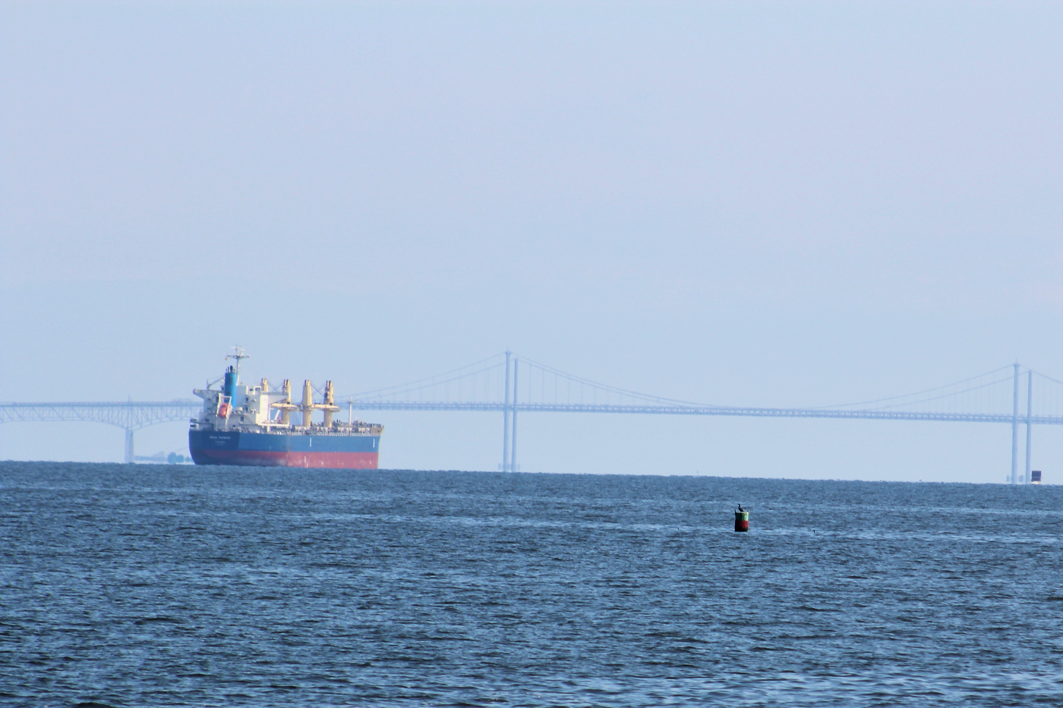
    This week’s video shows Still Waters II cruising down the Eastern Shore of the Chesapeake Bay.  The clip starts with some smooth sailing in calm waters.  The clip then transitions to some choppy water, and ends when a cargo ship and car carrier converge near the south end of the Bay.  Enjoy!

    To see past videos, click on the link to the Still Waters II Vimeo site.  The library now contains 43 videos of Still Waters II cruising America’s Great Loop

    Tuesday, October 31, 2017

    The crew took advantage of the calm conditions to make it south to the Kent Narrows.  They arrived about 1600.  They were the only boat at the marina.  After they landed, they went to the Jetty Restaurant to enjoy another dock and dine experience.  While dining, the Admiral asked if they could stay on the dock for the night.  The Manager agreed to allow them to remain on the dock for the night.

    the jetty
    From The Jetty website.  Still Waters II was docked where the big boat is at, top left.

    Wednesday, November 1, 201

    The run today started out well.  In fact, about noon, things were going so good the crew decided to skip the anchor spot in the Choptank River and continue south to the Honga River where they had planned to anchor tomorrow.  The winds were out of the east at about 8 mph which resulted in fairly flat seas.  This looked to be a good decision until 1330.  Then suddenly, as is prone to happen on the Bay, the wind changed direction out of the south and the winds picked up to 12 mph.  This made the last three hours rocky as the crew cruised in 2-3 foot waves with occasional 4-5 footers.  A little boat spray from the pounding waves:

    12.1

    After the crew dropped anchor in the Honga River, the winds died down and the crew had a calm night on the hook.  Watching the sun set while at anchor.

    13 Sunset Honga River

    Thursday, November 2, 2017

    The crew awoke to very calm conditions this morning.  The winds were light and stayed less than 5 mph out of the south all day.  with these flat calm sea conditions, the crew once again decided to skip a scheduled stop and push further south.  There are strong winds predicted for the weekend and the crew has set a goal to get off the Bay while it is still calm.

    At some point on the way south, they counted 17 fishing boats working the same general area.  They watched intently as every once in a while a boat would pull up a basket and dump the contents.  However, they were not ever close enough to tell what the fisherman were keeping.

    14 Fisging Boats

    The skipper guessed that they must have been working an oyster bed.  The next day, the skipper’s guess was confirmed when an oysterman came to the dock with his ‘catch.’

    IMG_0034

    As the crew passed Tangier Island, the skipper decided to run a controlled experiment on the claims that the water level of the Bay is rising significantly.  You may recall that Al Gore often makes this claim as he peddles his brand of global warming.  His claim is that warming is causing the water level to rise and will eventually overtake the Island.


    15 Tangier Island
    Tangier Island


    So the skipper decided to apply the scientific method to Al Gore’s claim:

    Step 1: Ask a question. – Can we measure a difference in water level of the Bay to prove Al Gore right?

    Step 2: State a hypothesis. – If water level is rising,  then we should be able to measure higher water levels from past Bay water level measurements.

    Step 3: Test hypothesis. – Water levels were measured (sounded) back in the 1800’s.  Todays charts are based off of these 1800 measurements.  The charts used for the measurements were the NOAA charts, latest survey data updated in 1987.  These charts show Mean Low Water Level.  While passing by Tangier Island, the skipper will take three soundings of specific areas where he has agreement in the charts as to past water levels.  The soundings will need to be compensated for the tidal change at the time of the soundings.

    Step 4: Analyze Data. –

    Time 1850’s Chart Depth 1987 Chart Depth Tide Change Expected Value

    1987 data + tide change =

    Measured Value

    Oct 26, 2017

    Result
    1230 59 58.7 + 1.6 60.3 59.9 Lower
    1247 58 57.7 + 1.51 59.21 57.8 Lower
    1300 43 43 + 1.43 44.43 43.9 Lower

    First observation is that the water level was either the same or lower from the 1850’s charts to the more accurate measuring systems of 1987.

    By adding the expected tide change to the 1987 chart data we arrived at an expected depth value.  Since the chart depths are ‘Mean’ water levels, we would expect some small variations in actual measurements.

    The water was calm, as can be seen in the above photo,  so waves did not effect the measurements.

    Second observation is that all three measured values were lower than expected value.  These differences were less than six inches and can be accounted for by the ‘Mean’ explained above.

    Step 5: Draw Conclusion. – The water level as measured is basically unchanged.  Because the water level is unchanged our hypothesis that water level is rising is wrong.  Therefore, Al Gore is wrong.  Go figure!

    Step 6: Communicate Results. – See above.

    The skipper loves science!

    OK, back to cruising ……….The main reason for pulling into Onancock was to try the healthy hole foods (donuts) and sticky buns from the Corner Bakery.  Some friends have told the crew that the sticky buns are the best in the world.

    18.1

    The donuts were very good, but they were sold out of sticky buns by the time the crew arrived.  In fact, the Admiral says the donuts might be the best donuts ever.  This was probably a good sign.   Another good sign was when they found this guy working the counter.  How can you go wrong when this guy is your counter help?

    18.2

    The skipper will get up and go get some sticky buns in the morning before they shove off the dock.

    Sunset at Onancock Wharf:

    IMG_0032

    Friday, November 3, 2017

    The Corner Bakery opened at 0730 and the skipper arrived about 0800.  He got a dozen donuts, but would have to wait until 0900 to get the coveted sticky buns.  While he was waiting, the Bakery began to fill with 5-6 older men sitting around a table drinking coffee.  When the first guy entered the Bakery, the man gave the skipper a strange look.  When a second guy entered and gave the skipper ‘the eye’, he finally figured out he must be sitting at the local ole guy fettle fart club table.

    The guys were entertaining to listen to.  One of them was a 91 year old WWII Navy Veteran.  Once the group learned that the skipper was also a Navy Veteran, they forgave him for sitting at their table.

    The WWII Veteran told an interesting story about how his ship was sunk by a couple of Kamikaze pilots near the end of the war as the Navy was closing in on Japan.  The survivors of the sunk ship were all given 30 days ‘Survivor Leave’ and sent back to the States.  He was actually still home on Leave when Japan surrendered.  The Navy processed him out of the service while he was on Leave, and he never had to go back.

    After the sticky buns were procured, the skipper said good by to the locals and commented that he would be back in the spring.  The Romeo’s (retired old men eating out) said they would be there waiting to talk again upon his return.

    I bet they are there everyday, so yes, they will be there in the spring  also.

    The skipper delivered the goods to the boat and the crew shoved off for Norfolk. And yes, the sticky buns were as good as advertised.

    The crew did not see any other cruisers until they got close to Norfolk.  As they left the Chesapeake Bay and entered the Elizabeth River, they had several boats following them.

    IMG_0038

    When they neared the Waterside Marina, they passed by mile zero of the Atlantic Intercostal Waterway (AICW) marked by this red buoy.

    IMG_0042

    The crew then passed by this building welcoming them back to Norfolk.

    IMG_0043

    The marina and waterfront have been under renovation since the crew last stopped here.  The new marina look.

    IMG_0044


    Boat Name of the Week

    Norfolk

    Next Week –   

    The crew will continue south on Monday and hope to make Beaufort, North Carolina by next weekend.  They do have two large bodies of water to cross and will wait for the proper weather conditions before putting in those areas.  So we will have to wait and see how far they actually go.

    Loop On – The water goes on forever and the adventure never ends.

    Eric the Red

  • Knot for the Faint of Heart

    Hello virtual crew members and fellow adventurers!

    Eric here with the latest travels of Still Waters II.

    Yes, you saw that right.  That guy just climbed 60 feet up that catamaran mast to do some work with no fall protection.  Even carried his tool bag up with him.  Hope he has the right size wrench.

    IMG_0007

    IMG_0006

    Summary of week:

    It was a short week with only two days of cruising.  The crew left Cape May on Sunday and anchored in the Salem River at the northeast end of the Delaware Bay.  On Monday, they crossed the Chesapeake and Delaware Canal into the upper Chesapeake Bay.  They ended the cruise up the Sassafras River where they will wait out some weather.

    Sassafras River

    Click on the link to read the day-to-day travel log.  This includes: weather report of the day, sea conditions, log of the days travel, and a summary of the experience.

    At the Box Office

    This week’s video shows Still Waters II cruise thru some light fog in the Cape May Canal, overtakes two sailboats in the fog, stops in the C&D Canal to watch a large wooded sailboat cruise by, and then pulls into the Chesapeake Inn for lunchEnjoy!

    Cape May to Georgetown Yacht Basin from Still Waters II on Vimeo.

    To see past videos, click on the Still Waters II Vimeo site.  The library now contains 42 videos of Still Waters II cruising America’s Great Loop.

    Sunday, October 22, 2017

    The weather is predicted to turn bad with high winds and rain late Monday.  It is only two travel days to the Georgetown Yacht Basin up the Sassafras River and out of the wind.  To arrive safely on Monday, the crew left in the fog on Sunday.  There seems to be a little irony in that.

    Cape May Canal

    After five hours of fog with varying degrees of visibility, the fog finally lifted.  The cruise to the Salem River then became routine.  This was actually the smoothest cruise on the Delaware Bay to date.  Sure beats the three foot waves the crew normally encounters here.

    After arriving at the designated anchor spot, the skipper noticed these two raccoons eating berries in the top of the tree.

    1 Three Racoons

    However, when they finally were done eating, the skipper counted three raccoons climb down out of the tree.  Two of the three are on the way down in this pic.

    1.2

    When the skipper was looking at the first pic, he noticed the third raccoon staring back at him in the top right corner.1.4

    After being entertained by the raccoons, the crew enjoyed a peaceful sunset.

    2 Sunset Salem River

    Monday, October 23, 2017

    The next morning, the skipper enjoyed the sunrise on the Salem River.  Hard to believe the wind will be up over 20 mph later today, when it is this flat calm in the morning.

    3 Sunrise Salem River

    While making way out of the anchorage to the Delaware River, this Bald Eagle took off from the green navigational aid and flew right across the bow of the boat.

    4 Bald Eagle Salem River

     4.1

    The fall color was great along the C&D Canal, and the skipper noticed a Bald Eagle admiring the beauty.

    5 C&D Canal

     7 Bald Eagle C&D Canal

    The skipper also noticed a large sailboat was sneaking up on them from behind.  In the distance, it appeared to be a pirate ship.  The skipper slowed to allow the pirate ship to close in, then suddenly, the skipper made a U-turn in the middle of the canal and faced the pirates down.  The pirate crew gave a friendly wave as they passed by.  With the pirate threat resolved, the skipper pulled into the Chesapeake Inn for lunch.

    6 Sailboat

    After lunch, it was another three hours to the Georgetown Yacht Basin where the crew will sit and relax for a week.

    The skipper did ask the dock master about the tides in the marina.  The dock master said that they had two foot tides and they were presently at low tide.  The water level was about four feet below the boards on the dock.

    Tuesday, October 24, 2017

    The crew woke to some unusual surroundings.   The rain poured most of the night, and the wind howled all night.  The wind was out of the south east and blew up the Sassafras River.  The wind actually blew water out of the Chesapeake Bay and up the Sassafras River.  Along with the rain and water runoff, the river reached flood level.  The dock office at the end of the pier was in about 8 inches of water.  Remember, yesterday the water was four feet below these docks.

    IMG_0002

    The water continued to rise until the crew’s dock was several inches under water.  This pic was taken about an hour before high tide, and the water rose another few inches after the pic.  It took the rest of the day for the waters to recede.

    IMG_0003

    Boat Name of the Week

    The Wall Street Journal published a list of  boat names this week, from the Coast Guard database, with a financial theme.  Some favorites:

    Broke But Tan,

    Broke For Shore,

    Float’n-a-Lone,

    Fueli$h Money,

    Floating Interest,

    A Loan @ C,

    Knot Cheap,

    Debtors Delight.

    Next Week – 

    The winds are predicted to be less than 10 mph on Tuesday, so the crew plans to shove off and head south down the east side of Chesapeake Bay.  Hope to make Cape Charles by the end of the week.

    Loop On – The water goes on forever and the adventure never ends.

    Eric the Red

  • Recalculating

    Hello virtual crew members and fellow adventurers!  Eric here with the latest travels of Still Waters II.

    We have a new virtual crew member, Welcome Aboard KMHowitt!!

    Summary of week:

    BBYHThe crew only travelled two days in the past week.  On Tuesday they cruised to the Middle River and meet some new friends.  On Wednesday they made their way to the Elk River and then the Bohemia River before docking at the Bohemia River Yacht Harbour.

    Click on the link to read the day-to-day travel log.

    Still Waters II VIMEO site

    At the Box Office, this week there is no new video.

    To see past videos, click on the link to the Still Waters II Vimeo site

    Monday, July 17 , 2017

    You might recall the crew met a boat back in Zimmerman’s who had engine trouble and was having one engine rebuilt.  The trouble was due to the raw water pump impeller failing which lead to the engine overheating.  The skipper asked the mechanics how often one should change out the raw water pump impeller and the answer surprised the skipper.  They recommended replacing the impeller annually.  Still Waters II’s impellers were last changed in June 2015 when the crew first moved onboard.

    Since the skipper believes that an ounce of prevention is better than a pound of cure, he decided it was time to change the impellers.  The marina did not have the impellers that the skipper needed, so Zimmerman’s had the impellers delivered to the Herrington Harbour North marina.

    On Monday morning, the skipper walked over and picked up the impellers.   He then spent most of the day changing the impellers out.  It was a good thing the engines had not run in a few days because the engine room was hot enough without any additional heat.  Turns out that his time was well spent because the impeller blades had began to crack and failure was imminent.

    Tuesday, July 18, 2017

    88 Tim & Terry
    Tim & Terry

    Tim and Terry became virtual crew members back in May 2017 when they began to follow the Still Water II adventures.

    Tim and Terry are in the planning phase of cruising the Loop and reached out to our crew to see if they could arrange a face-to-face meeting.

    The crew was excited to meet some virtual crew members and help them with any questions that they might have about the Loop.

    The crew made a calm cruise up to the Middle River and docked at Bowley’s Marina.  The cruise did take the crew past some landmarks on the Bay.

    The Thomas Point Shoal Light

    The lighthouse is the only screw-pile lighthouse in the Bay which still stands at its original location.  The light was originally lit in 1875 and was added to the National Register of Historic Places a hundred years later in 1975.  The light was automated in 1986.  The white light has a range of 16 nautical miles while the red light has a range of 11 nautical miles.  The Coast Guard was passing by as the skipper was taking this shot.

    45

    The Chesapeake Bay Bridge

    From the Colonial Period until the Bay Bridge was completed in 1952, Ferries were used to cross the Bay.  Talk of building a bridge across the Bay began in the 1880’s.  The bridge was finally authorized in 1927, but because of the economic collapse of the Great Depression construction was cancelled.  The construction was further delayed because of WWII.  Ground was finally broken in January 1949, and the bridge opened to traffic July 30, 1952.

    The bridge at one point is 186 feet above the water.  The narrow lanes, with no shoulders, and low guardrails, have earned the bridge the title of one of the scariest bridges to drive across.  At a little over four miles to cross in high winds, yes that would be a scary ride.

    46 five miles out from Bay Bridge
    Five Miles from Bay Bridge
    48
    Passing under Bay Bridge

    The Sandy Point Shoal Light

    This light house was originally lit in 1883.  She was added to the National Register of Historic Places in 2002.  In 2006, the Coast Guard auction the lighthouse off to a private bidder after unsuccessfully trying to get a non-profit to take the lighthouse.

    50 Sandy Point Shoal Light

    After arriving at the marina, the crew got settled and awaited the arrival of their guests.  Tim and Terry arrived about 1730 and suggested the By the Docks Seafood Restaurant.  They also suggested the crab cakes.  The foursome enjoyed the meal and talking about the Great Loop.  The Admiral believes that the crab cakes were the best she has ever eaten.

    After a great meal the four returned to the boat and continued to talk about the Loop.  Tim and Terry also shared about a week charter that they had taken back in May.  They charted a Grand Banks and spent a week cruising the Chesapeake Bay.  However, some folks still have to work, so Tim and Terry departed and headed for home.

    The crew had a wonderful time and hope and pray for Tim and Terry to be able to fulfill their dream of cruising the Loop.  Until then, our crew is glad that they are virtual crew members aboard Still Waters II.

    Wednesday, July 19, 2017

    The crew left the Middle River and made their way to the Elk River and then the Bohemia River where they docked at the Bohemia River Yacht Harbour.  There was very little wind and things were shaping up for another hazy, hot, humid day.

    52 Looking out from Middle River
    Looking across the haze of the Bay from Middle River

    If you look closely at the pic above, you can see a small crab boat off to the left of center.  As the crew approached they were able to get a good view of the crab men working their pots.  The skipper was trying to take a picture and caught one of the guys with a big smile and a wave.

    54

    As the crew approached the Elk River they watched these four sailboats motor by.

    56

    Then about the time the skipper was about to turn to starboard and head into the Bohemia River, this behemoth came around the bend from the C&D Canal.  The skipper gladly got out of the big ship channel and let this big boy go by.

    61

    The skipper had tried to make reservations for a week at the Yacht Harbour, but the marina was full for the weekend so the crew would only get to stay until Friday.  The skipper spent some time while they were cruising trying to figure out where they might go for the weekend.  Upon arrival at the marina the crew was informed of a few cancellations and were able to secure a spot for the week.

    Saturday, July 22 , 2017

    The last few days have continued to be hot and humid.  However, the Bohemia Bay Yacht Harbour has a nice swimming pool.  The crew has been taking it easy and enjoying the A/C and pool.  They also have procured a rental car and headed over to Delaware City to visit Fort Delaware.

    The fort is on Pea Island in the Delaware River.  The current fort was  built from 1848-1860 to protect Philadelphia.  This is the third fort to be built on the Pea Island.

    During the Civil War, the Island was used to house Confederate POWs and political prisoners.  There were 51 Barracks built outside the Fort to house the POWs.  Each Barrack housed 250 prisoners.  The original Barracks are all gone, but this replica was built in 2001.

    81

    Inside the Barrack

    80 POW Barracks

    The crew arrived on Pea Island by a short Ferry Boat ride from Delaware City.  After arrival at the Island they took a tram from the waterfront dock to the Fort entrance.

    64 Ferry to Fort Delaware

    Shortly after arrival, they watched a cannon demonstration where a 5-man cannon crew loaded and fired the gun.  Interesting enough, the Fort had cannons aimed in the general direction of the Southern prisoners.  The threat of a cannon blast kept the POW’s in line because there was never any issues of rebellion from the prisoners.

    79

    The crew spent about two hours wandering around the fort taking the self guided tour.  There were many volunteers in period costumes in the rooms to answer questions about life at the Fort.

    Crossing the moat at the Sally Port

    67

    The Kitchen

    69

    The Mess Hall

    70 Mess Hall

    A few soldiers cleaning their guns

    72

    The Store Room Clerk

    73

    The Doctor was in

    76

    After a couple of hours, the heat and humidity had taken its toll and the crew was ready to make their way back to the main land.

    Boat Name of the Week

    The skipper is reading a book about the California Gold Rush, so he was a bit surprised at the timing of seeing this sailboat leave the Harbour.

    Fools Gold

    62

    Next Week –

    The crew will continue to sight see in the general area and start their move to New York City on Wednesday.  They hope to be in Cape May by Thursday and arrive in NYC on the following Monday.

    Loop On

    The water goes on forever and the adventure never ends.

    Eric the Red

  • Three H’s: Hazy, Hot, and Humid

    Hello virtual crew members and fellow adventurers!

    We have a new virtual crew member this week: cdb13212, Welcome Aboard!

    Some friends sent this picture of a ‘boat’ they saw cruising in Canada.  Yes, that is a outboard motor, on a raft, with a picnic table.

    73 Picnic Cruising

    Eric here with the latest travels of Still Waters II.

    Summary of week:

    Herrington Harbour North

    The crew has worked their way up the west side of the Chesapeake Bay.  They spent the first part of the week in Mobjack Bay getting some repair work done to the boat.  Then moved to anchor at Smiths Point for an exciting night on Thursday.  Friday they moved to Solomons and then on to Herrington Harbour North Marina for the weekend.

    Click on the link to read the day-to-day travel log.

    Still Waters II VIMEO site

    At the Box Office, no new video this week.

    Click on the link to the Still Waters II Vimeo site

    Monday, July 10, 2017

    The crew made the 21-mile jump from the York River over to the Mobjack Bay and then up the East River.  The run was short but very picturesque.  At one point, the skipper decided to Navigate thru the Swash Channel.  The channel is narrow with only 1-3 feet of water if you drift out of the channel.

    Entering Mobjack Bay

    46 Mobjack Bay

    The risk of running aground was worth the 10 miles it shaved off the route.  At one point the mean low level on the chart showed only 5 feet in the channel.  However, the skipper timed it so they would pass over this 5-foot mark at high tide.  The crew showed 7 feet when they cruised over the low area.

    The scenery along the East River banks:

    47

    48

    49

    The boat yard was ‘Johnny on the spot’.  They were on the boat quickly and diagnosed the problem and got the part ordered for the oven.  Unfortunately, the part is coming from the west coast.  We will see when it gets here.

    Tuesday, July 11, 2017

    Still waiting on the part, we need to fix the oven, a thermal overload.  The electrician did find a short to ground in some electrical wiring, got the short repaired, and now the three lights that were not burning will illuminate again.

    The crew decided to take the courtesy car into town and run a few errands.  They pulled into a Chick-Fil-A and were surprised to learn it was Cow Appreciation Day.  Everyone dressed as a cow got a free entrée.

    74 cows

    75

    Wednesday, July 12, 2017

    The electric part for the oven arrived, the electrician installed the part, and got the oven working again.  The crew made plans to leave on Thursday at high tide so they could get out of the shallow cove that leads back into the East River.

    In the meantime, the crew decided to go back into town to enjoy a nice meal and a Concert on the Green.

    They ate at a place called Lulu’s Birdhouse that came recommended by an office worker at the boatyard.  The food was delicious.  The deserts, even better!

    78

    After polishing off the cheesecake and coconut cake, the crew headed down the street to take in the Concert on the Green sponsored by the local Recreation Department.  The duo played and sang Irish and Scottish folk music.  Very entertaining.

    79


    Thursday, July 13, 2017

    The crew set off for Smith’s Point late in the morning.  They saw a local YMCA group sailing sunfish sailboats as they left the East River.

    51 Sunfish sailors

    They made their way past the New Point Comfort Lighthouse.

    52 New Port Comfort Light

    Then arrived at the Point Smith Light late in the afternoon.

    53 Smithpoint Light

    The crew got settled amongst the many crab pots and tried to stay in the shade while they waited for the sun to set and begin to cool off a bit from the high of 96 today.  After the sun set the crew settled in to what was believed to be a hot night on the water.

    The calm before the storm.

    55 Anchored at Smithpoint

    About 2300 lightening started so the Admiral woke the skipper and suggested he lower the antennae.  He did and then checked his weather radar.  The storms were all several miles north of the crew with winds out of the south.  They were sitting in cloudless skies with stars shinning abundantly.

    Just as the skipper was about to doze off again, he heard what sounded like rain on the water.  He got up and looked outside and noticed no stars, only a dark sky.  Then a high blast of wind hit him and then rain was blowing sideways rather than falling to the water.  He quickly shut the three boat hatches.  The rocking of the boat and noise woke the Admiral.  She started closing the windows on the sundeck.  The skipper hurried to the helm to check on the boat anchor.

    The wind was pushing the rain so hard that it just looked like a blanket of water pounding the boat windows.  The skipper could tell that the wind was pushing the boat and dragging the anchor, but visibility was so poor he could not see the water below the boat much less any lights on land that might give a clue where they were moving.  He cranked the engines on and then fired up the chart plotter.  Before the chart plotter came to life both engines died.

    And then just like that, the wind, rain, and clouds were all gone and the stars filled the skies above again.  The whole evolution from calm, to storm, and back to calm all took place in less than five minutes of time.  With visibility restored the chart plotter confirmed what the skipper could now see.  The boat was stuck in the mud about 10 yards from someone’s seawall.

    The skipper got out one of his fishing poles and dipped the tip into the water to determine the depth.  The boat was sitting in three feet of water.  Her draft is three feet nine inches, so they were shoved up in the mud good.

    The skipper found the tide tables and determined that high tide would be 0600 with about a foot of water.  That should be plenty to float them free.  While waiting on the tide to flow in and raise the water level, the skipper started using the anchor to try to pull the boat out of the mud.

    The skipper would tug and pull on the anchor chain while the Admiral used the windlass to take up any slack that might form.  They maintained this effort for the next four hours and managed to move the boat a few feet away from the shore.  The skipper kept checking then water level and pulling on the anchor chain.

    The efforts were finally rewarded about 0300 in the morning when a sounding showed the depth to be three feet nine inches.  The skipper went to the helm and fired up the port engine and she started and ran fine.  Good.  Then he bumped the throttle forward and the boat rocked and jerked forward.  Good again.  The skipper then started the starboard engine and bumped both throttles forward.  The boat rocked and lunged forward ever so slightly.  After bumping the throttles forward three more times, the boat finally broke completely free of the mud.

    The skipper and Admiral then managed to get the anchor back onboard and they slowly moved into deeper waters while trying to dodge the landmine of crab pots that they now found themselves surrounded by.  The crew managed to navigate the crab pot field and finally found an area they could reset the anchor.

    Then it was back to bed to get some well needed rest.  That was not to be either though.  At 0400, the first commercial fisherman started heading out to begin their work day.  Before the sun came up a little after 0600, at least a dozen fisherman in large boats with even larger wakes passed the boat.  The crew did not get much sleep the whole night.

    The scene of the crime so to speak.  The boat was between the crab pots and that white seawall and rocks.

    80

    Friday, July 14, 2017

    In the mornings, the skipper usually reads the AGLCA Forum.  This morning someone posted about the three H’s on the Chesapeake Bay this time of year: hazy, hot, and humid interrupted by 100 mph winds during thunderstorms.  Well the crew certainly experienced that last night.

    The plan was to head over to St Mary’s City to visit the historic area and end the day with a concert in the park.  However, St Mary’s does not have a dock so one must anchor out and dinghy in to visit the town.  After the misery of last night, and the weather predicted to be in the high 90’s with greater than 88% humidity the crew decided to pass St Mary’s City and push further north where they could find some A/C.

    The cruise across the mouth of the Potomac River was rough, but after the crew got to the north shore of the river the waves calmed down.

    57 Potomac River convergence with Bay

    With winds out of the west-southwest, the crew had following seas with one foot swells pushing them all the way to Solomons.

    The Point No Point Light out in the Bay.

    58 Point No Point Lighthouse

    Upon arrival at Solomons they witnessed a large fleet of sailboats racing.  The skipper counted 35 boats in the race.  However, they were glad to finally get off the Bay and into Solomons.

    60

    After getting tied up and secured along the dock, the skipper got the shore power hooked up and the A/C units running.  The power kept tripping on the marina power pole so the skipper finally hooked the shore power cable to a different shore pedestal and they have had no further issues.

    Because of the heat and humidity, the storms rolled through again.  The good news is that it cooled things off a bit.  The boat A/C units were struggling to bring down the temps inside the boat.

    Saturday, July 15, 2016, 2017

    The sailboat race that the crew witnessed yesterday continued on Saturday.  The sailboats were all headed out to the Bay the same time our crew was leaving.  There was energy and excitement in the air as the sail boaters were maneuvering to the start line.

    64

    After weaving and dodging sailboats the crew got back in the open Bay.  They stayed a mile or so off shore which gave a smooth ride due to the northwest winds.  The wind did not have a chance to kick up any large waves.

    65 Leaving Patuxent River

    This guy is living on the edge.

    67

    Cruising past the Point Cove Lighthouse.

    68 Cove Point Lighthouse

    The famous Calvert Cliffs along the western shore.

    69 Calvert Cliffs

    Upon arrival at Herring Bay, there was another large crop of sailboats out in the water.  The skipper had to slow to negotiate around all the Saturday Sail boaters.  This shot is of the boats coming and going out of Herington Harbour.

    71 enter Herrington Harbour North

    The marina is one of the nicest the crew has stayed at on this adventure.  The crew enjoyed a complimentary showing of Beauty and the Beast last night on the marina grounds.

    Boat Name of the Week

     72

    Next Week –

    The crew has a couple of more stops planned in the upper Chesapeake Bay before crossing the C&D Canal over to the Delaware Bay.  They hope to make Cape May by next weekend, if the weather cooperates.

    Loop On – The water goes on forever and the adventure never ends.

    Eric the Red