Tag: Shore Excursion

  • Shell of a Day

    Hello virtual crew members and fellow adventures!

    img_0106

    Eric here catching you up to date on the latest travels of Still Waters II. Click on this link to see the day- to-day travel log.

    I would also like to welcome aboard Cookie G. as our newest virtual crew member.

    Summary of week:

    The crew left Venice and made their way to the Pelican Bay anchorage across from Cayo Costa State Park.  On Friday they headed to Ft Myers to enjoy the Edison Festival of Lights.

    ft-myers

    Sunday – Tuesday, February 12-14, 2017

    The crew continued to enjoy the laid-back retirement vibe of Venice.  They walked the historic downtown and actually found the worst fudge on the loop.  How fudge can be so creamy and have almost no taste is baffling to the skipper.  He was a trooper though and suffered thru the pound of peanut butter fudge he bought.  The Admiral did her part to eat the chocolate fudge, but in the end the skipper took one for the team and finished it off also.

    venice-bike-trail
    Venice bike trail running along side the ICW

    The crew spent much of Tuesday riding their bikes around the island and walking the many beaches of Venice.  The crew is still amazed how empty the beaches seem to be, even in this peak season for Venice.  The only thing that seems to be full are the restaurants.

    23

    There is one restaurant at the marina that opens at 1100, closes at 1000, and is packed the whole day.  Cars sit in the parking lot roadway waiting for a car to leave so they can pull up just to get a parking space.  Boaters actually make the marina a destination just to go in and eat.

    With all this activity, the crew had to check it out for themselves.  The Admiral had a wonderful fish sandwich and the skipper’s grouper bites were outstanding.  Best of all, they actually found a lull in the activity mid-day and only had two people in front of them in the wait line.  Yes, life is good on the beach.

    22
    A bad day fishing is better than a good day at work

    You know you are in a quiet town when the big thing to do is drive to the park and watch the nightly sunsets over the ocean.  But as they say, when in Rome do as the Romans do, so the crew would go walk out to the jetty and sit and watch the dolphins play while the sun would slide down and out of site.

    11-venice-sunset

    Tuesday night the crew sat and talked with a couple of locals as the sun did its thing.  After the sun went down the crew invited them aboard for a quick tour of the boat.

    13-venice-jetty

    The Snow Moon was also visible coming up in the east one evening.

    16

    This 1926 wooden yacht made its way to Venice and tied up next to Still Waters II.  The owner is selling 20 shares in the boat for $500,000 each.  But do not take too long to make your decision because there are only three shares left.

    28

    30

    If part ownership in a yacht is not your idea of living the dream, maybe this 48 foot Cat that also parked next to Still Waters II is more your style.  It can be yours for a mere 12 million.

    hayfu-ii-front

    Wednesday, February 15, 2017

    The crew set out towards Pelican Bay today with the idea that they would anchor for two nights.  However, mother nature was back to huffing and puffing with high winds so they were not sure if they would anchor or not.

    img_0052
    On the way to Pelican Bay

    About half-way to Pelican Bay they ducked into Cape Haze Marina for fuel.  Active Captain showed the diesel price at 2.02, the cheapest fuel in Florida, and the skipper was not going to pass that up.  The marina sells fuel at their cost.  It was a bit trying to get Still Waters II back into the fuel dock but the skipper finally made the dock.  After taking on 132 gallons of fuel, the skipper was delighted to learn that the price was 1.90 a gallon.  Yes, sir re Bob, this is a good deal and worth the trouble.

    img_0053
    Tad bit shallow for Still Waters II

    After the fuel stop the crew made way to Pelican Bay.  When they arrived, there were already 15 boats in the anchorage.  The skipper found a good spot and the crew became boat number 16.  About an hour and a half later, two sailboats came in and joined the party.  The cruising guide said this was a popular anchorage, but who knew this many folks would be here mid-week.

    img_0056
    A few of the newest neighbors

    Thursday, February 16, 2017

    The skipper launched the new Walker Bay dinghy and rowed over to the Cayo Costa State Park dinghy dock.

    img_0057

    Upon arrival, he walked about a mile to the Gulf side of the island.

    img_0059

    If you have ever hiked with the skipper you will recognize this next line, “the beach is just around the next bend.”

    img_0060

    After arriving at the beach, the skipper found this most amazing shrub.  He did not know that shells grew on trees.

    img_0061

    After getting a mile from the campground he discovered shell heaven.  He found nine Sand Dollars and many large sea shells.  In fact, there were so many shells he could not possibly harvest them all.  He found a few good samples to take and left the rest for the next person to make their way down the beach.

    img_0066

    A few other interesting finds along the beach…..

    img_0062

    img_0065

    A few birds were in formation along the shore guarding the shells.

    img_0069

    On the way back to the dinghy dock a Park Ranger picked up the skipper and saved him the mile walk back to the dinghy. Now all he has to do is row back out to Still Waters II.

    img_0070
    Still Waters II at anchor in Pelican Bay

    Friday, February 17, 2017

    Low tide was at 0800 this morning, so the crew had to wait for the tide to rise before setting out to clear a shallow spot in the entrance of the bay    When the crew went to weigh anchor, they found grass wrapped around the anchor chain.  With a little more than 140 feet of chain out, it took about 40 minutes to retrieve and clean the anchor chain.

    img_0071

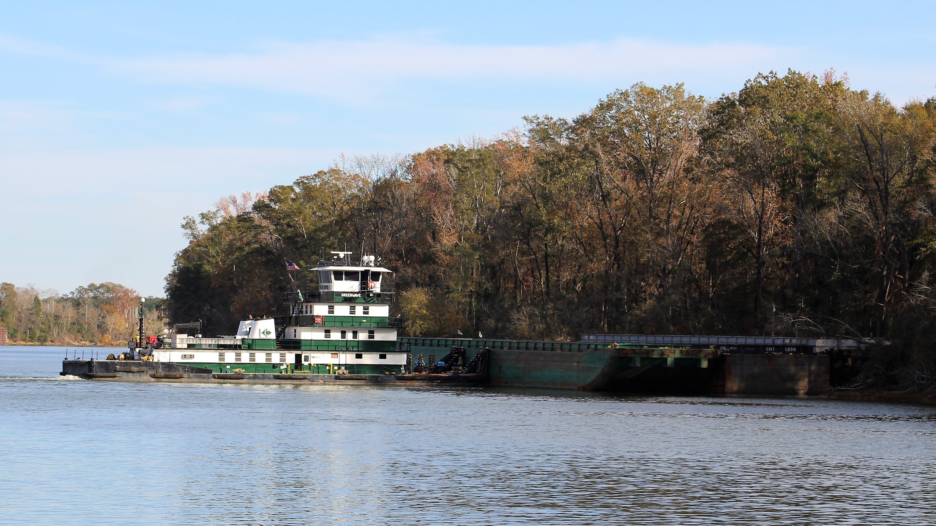
    Once underway, the crew had a wonderful day on the water.  The weather was perfect for a day on the water so there were a lot of other boaters out enjoying themselves.  It was not uncommon to see at least seven boats headed towards Still Waters II at any given time.  The crew is glad that they are not making this run on Saturday.

    img_0078

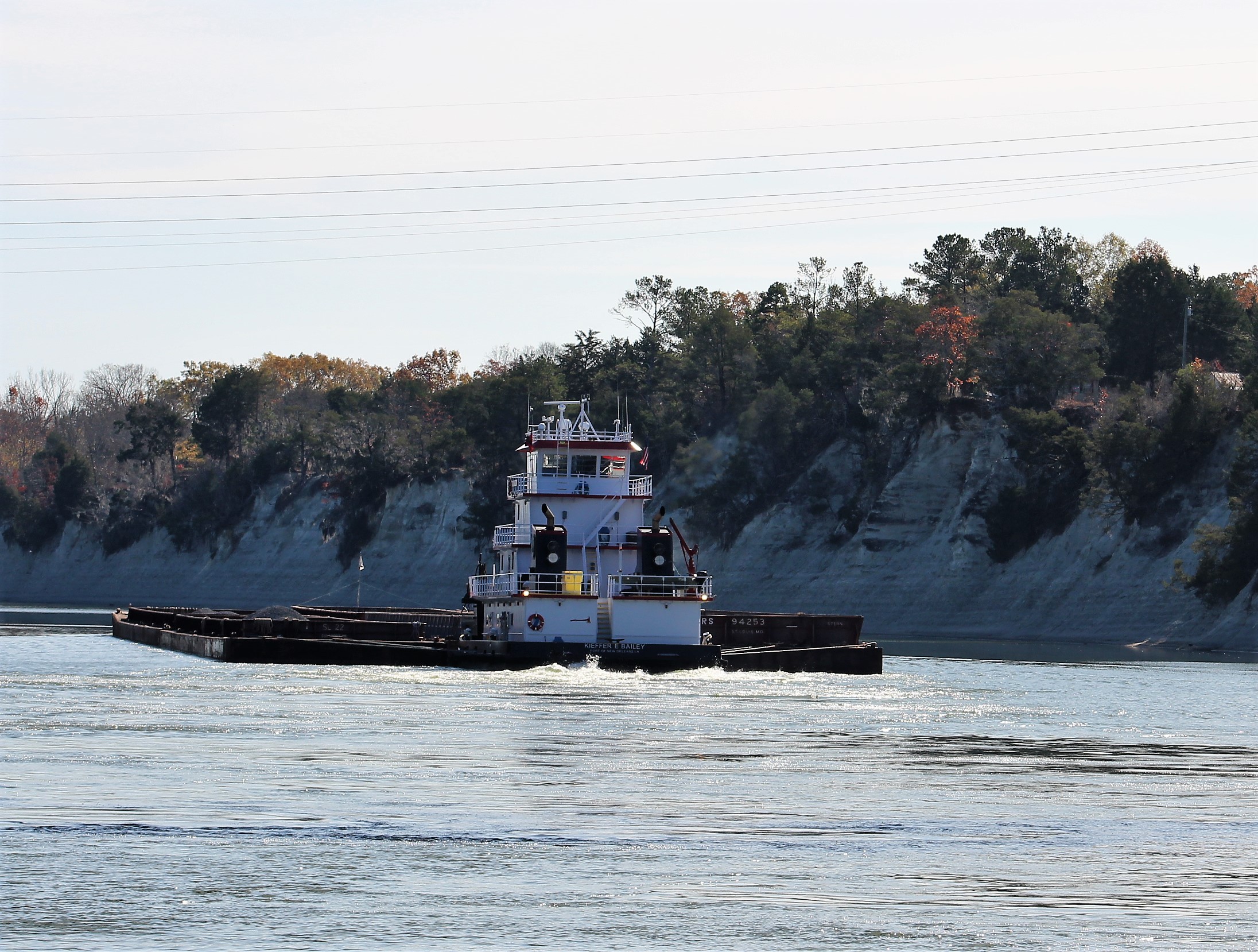
    As the crew continued south on the GICW, they finally came to day marker red 16 which is the furthest the crew will travel south on this loop adventure.  After passing red 16, the crew turned northeast and headed to Ft. Myers.

    img_0081

    Headed up the Caloosahatchee River towards Ft. Myers.

    img_0088

    This water front store brings a whole new meaning to the words convenience store.

    img_0090

    Turns out that this weekend is the Edison Festival of Lights and the largest parade in the southeast will be Saturday night.  This also means that the marinas are all full, but the crew snagged a slip because a long-term slip holder had his boat out for maintenance and agreed to allow the crew to use the slip for the weekend.

    img_0098

    The crew feels pretty fortunate to have gotten a space to stay.  The crew talked to some boater friends that they found over in the west bay of the marina and learned that they book their slips a year in advance to ensure they have a spot for the Festival.


    img_0099
    Yes, the 300 slip marina is full

    After docking the crew walked over to the main stage of the Edison Festival of Lights and listened to some live music.

    The first band played the blues and were pretty good.

    img_0109

    The second band was named SOWFLO and played rock/reggae.

    img_0117

    Saturday, February 18, 2017

    The crew discovered another public art display in the Ft Myers River District.  This was a 25-piece exhibit of Colombian artist Edgardo Carmona.  The exhibit just completed an 18 city tour in Europe.

    A few of the pieces…….

    img_0127
    10.0

    A snow cone vendor

    img_0132
    El vendedor de raspo

    Fixing to score 10 points on the next domino play.

    img_0133
    Juego de Domino


    img_0134
    Faena En La Plaza
    img_0140
    Trialogo

    While walking around in the morning to look for the art work, the crew noticed that the parade route sidewalk was almost already ‘reserved.’  People had come and placed tape down to mark there spots.  The skipper asked the locals about the practice and the locals all agreed that it was an acceptable practice and people honored the system.

    So come early in the morning, mark your spot, go home, and show back up at 1800 to claim your good spot on the parade route.  The skipper is not sure what he thinks of this system.

    img_0130

    Speaking of marking your spot.  One last sculpture.

    img_0145
    Territorio

    The parade turned out to be a little soggy.  The rain began to fall about 1700, two hours before the start of the parade.  There was a light drizzle for most of the parade.  But it did not seem to put a damper on the parade entrants or crowd.  There were over 130 entrants and it took almost two hours to pass by where the crew watched the parade.  The crew is glad they stayed and watched the parade, but are not going to be booking a year in advance to be back.

    Next Week

    The crew is only 10 miles from their ultimate goal of crossing their wake at Sweetwater Landing and completing their Loop Adventure.  After taking a few days off to celebrate they will head across the Okeechobee Waterway and head south towards Miami.

    Loop On – The water goes on forever and the adventure never ends.

    Eric the Red

  • Crabby Bill

    Hello virtual crew members and fellow adventures!

    17-dolphin-trail-crabbybills
    Crabby Bill Dolphin

    Eric here catching you up to date on the latest travels of Still Waters II. Click on this link to see the day- to-day travel log.

    I would also like to welcome new virtual crew members Port Canaveral Transportation. I am not sure where we will put the limo yet, but I am sure we will figure something out.

    Welcome aboard!

    Lastly, I will be dedicating this post to a good friend of the skipper, Bill Nix.  The skipper and Bill met back in 1987 and became good friends and fishing buddies.  Bill was also a huge fan of Salvador Dali’s work.  He also has an uncanny resemblemce to Crabby Bill.

    img_1920
    Bill Nix, friend extraordinaire
    18-crabby-bill
    Crabby  Bill ‘s is a favorite restaurant of the crew


    Summary of week:

    The crew left Clearwater and cruised to Gulfport to visit the Salvador Dali Museum.  After a surreal experience in Gulfport they made their way to Venice.

    Monday February 6, 2017

    With only a short run of 25 miles to Gulfport, the crew got a late start.  What a difference a few days makes.  With everybody back at work there were very few boaters on the water today.  A much more comfortable and enjoyable time today on the water.

    1-gicw-to-gulfport
    Condos lining the GICW

    Much of the run was through condo lined beaches and shores.  When there was not a condo there would be private residences.  This meant that the NO WAKE signs were posted along most of the run today which slowed progress down.

    5-mcdonalds-dock-and-dine
    McDonald’s on the water = milkshakes and hot apple pies for crew members

    The skipper noticed that a McDonalds was positioned along the water with a private dock.  The crew decided to dock and go buy milkshakes for an afternoon snack.  An added bonus was a Publix grocery store next door, so the Admiral also made a small provisioning run for a few items that the crew needed.

    4-mcdonalds-pier
    Arriving at the McDonald dock

    After arriving in Gulfport, the crew took a short walk to check out the waterfront part of town.

    img_0494
    Overhead view of Gulfport Municipal Marina


    11-mural-on-beach-st
    Manatee mural on side of business

    Of course, the Admiral found the swing overlooking the Bay.

    15-and-she-was-swinging

    Tuesday, February 7, 2017

    Today’s destination was the Dali Museum which houses the largest collection of Salvador Dali’s work outside of Europe.

    17-dali-museum
    Dali Museum

    The crew wanted to stay at the St. Petersburg Marina which is next door to the museum, but the transient docks are under repair and their was no slip available.  Thus, they went to Gulfport which is about eight miles from the museum.

    19-spiral-staircase
    Spiral staircase inside the museum

    The skipper found a bus route that was near by (1 mile walk to pick up bus) and that would drop the crew off within a quarter mile of the museum.  The bus ride took them through some of the finest neighborhoods in St Petersburg, NOT!

    After arriving at the museum, they purchased tickets and took the audio tour of the museum and exhibits.  The audio tour was excellent.  If you would like to participate in the audio tour, go to the app store and download the free Dali Museum Virtual Tour app.  The app will show the works on exhibit and give a brief explanation on the piece.  The app is the same tour we had at the museum.

    20-early-self-portrait
    17 year old Dali self portrait
    23
    The Disintegration of the Persistence of Memory

    The above painting was a redo of his Persistence of Memory painting that he completed in 1932.  The above project was completed in the 1950’s after atomic energy was discovered and shows time melting away while the other parts are breaking down into their subatomic pieces.

    21-dual-image
    Gala Contemplating the Mediterranean

    The above painting is a double image.  At the museum, if you stand 20 meters from the painting you can see a portrait of Abe Lincoln.  If you squint your eyes while looking at the pic you can see Lincoln.  Also, if you hold a mirror up to the painting or pic and look at the reflection you can see Lincoln.

    26-rr

    The Rolls Royce was an interesting piece.  Usually you get in a car to get out of the rain.  If you look at the driver, you will notice he has on a deep dive suit and helmet.  The backseat has been enclosed and water is falling along the windows.  The passenger is a mermaid.

    28-dali-moustahe
    Famous Dali moustache in the gardens.

    Another neat exhibit was a virtual reality tour of the painting Archeological Reminiscence of Millet’s “Angelus”.

    dali-pic

    The virtual reality tour put you in the painting and you could walk around inside the painting to explore it closer.

    Overall, this was an exceptional day for the crew at the Dali Museum.

    Now all they have to do is figure out how to get back to the boat using their all day bus tickets.  There is always adventure around every corner.  They got on a route 23 bus that should have taken them within about half a mile of the marina.

    But somewhere on the route the bus driver stopped and got off the bus.  A few minutes later he got back on the bus and took off again.  The skipper noticed that they were now on route 14 verse 23.  The skipper pulled up the route maps and laid 14 and 23 out together.  He found a spot where 14 and 23 intersected.

    At the intersection, the crew got off the 14 bus and had to wait 20 minutes for a 23 bus.  Once on the 23 bus they were once again headed in the right direction.  The 7 mile distance back to the marina took almost two hours to execute.  hmmm

    Wednesday, February 8, 2017

    As the crew traveled further south on the west coast of Florida, the competition for marina slips has begun to increase.  The crew had planned to stay in Sarasota for a few days, but the marina slips were not available because a Yacht Club had arrived and taken most of the spots through the weekend.  There was one mooring ball available, but the wind is supposed to kick up to 20 mph on Thursday and the crew did not want to be out in the middle of the water bouncing around in the wind and waves tethered to a mooring ball.  The crew opted to move further south to Venice.

    3-tampa-bay
    Crossing Tampa Bay

    The 52-mile run was made even longer because the course went through some narrow channels that were marked for slow speed due to Manatee Zones.

    6-sailboat
    Following a sailboat in a manatee zone

    When the crew was not in a manatee zone they were in areas with houses and canals which were posted No Wake.

    7-canal
    One of hundreds of canals lined with boats in this area

    Overhead view of a few canals.

    img_0495

    Then there were the million dollar homes that lined the shore also.

    8-million-dollar-homes
    This home has water on three sides

    The crew eventually arrived in Venice where they will hang out for a week because the marina provides a  pay for 5 nights, get 2 nights free.  The skipper has trouble passing up free.

    img_0496
    Docked at Crow’s Nest Marina

    Saturday, February 11, 2017

    The crew spent an uneventful day cleaning and working on the boat yesterday, so today they decided to walk around historic Venice and check the place out.

    19
    One of the places the locals and snowbirds come to watch the sunsets.

    The first observation is that this is definitely a place that the retired crowd has taken over.  There are not many folks under 50 even visible.  The beach is full of older folks but no youngsters.  It is a very quiet and peaceful town.  There also is a very large snowbird population here based on the license plates driving around town.

    11-venice-sunset
    Sailing at sunset

    The crew finally discovered an historical marker that explained the retirement vibe going on in town.  The town was actually designed and built to be a retirement community for railroad employees.  The ‘city plan’ was completed in 1926 by John Nolen.  George A Fuller was selected as the contractor to build the town according to the plan.  The first road was completed in 1926.

    13-venice-jetty
    Folks watching the sunset from the jetty

    The Great Depression put a major hit on the development of the area and much of the plan was put on hold.  The town got a kick start when an Army Air Base was established here  in 1942.

    21

    23

    A sad claim to fame is that three of the 9/11 hijackers completed their flight training at Huffman Aviation which is located at the Venice Municipal Airport.

    16
    February Snow Moon from Marina


    Next Week – The goal is to actually make it back to Sweet Water Landing Marina by the end of next week.  You might recall that this is the marina where this adventure started back on June 28, 2015.

    The skipper is watching the weather and wind to determine the actual path and travel days to make these last 58 miles before crossing their wake and  hoisting the gold flag.

    Loop On – The water goes on forever and the adventure never ends.

    Eric the Red

  • D-Day, Gulf Crossing

    Hello virtual crew members and fellow adventures!

    5-ts
    Sponge Diver Memorial

    Eric here catching you up to date on the latest travels of Still Waters II. Click on this link to see the day- to-day travel log.

    I would also like to welcome Scott M. aboard as our newest virtual crew member.  Scott plans to start the loop in May 2017.  Welcome aboard Scott.

    Summary of week:

    The crew moved to Carrabelle on Monday and launched their Gulf crossing to Tarpon Springs on Wednesday.  They then moved to Clearwater on Saturday.

    gulf-crossing

    Sunday, January 29, 2017

    The wind was forecasted to lay down Saturday about 1600.  Well that did not happen.  In fact, the winds continued to blow all day Sunday, so the crew cancelled their anticipated run to Apalachicola.  The skipper was busy recalculating the next route based on the latest weather information.

    Monday, January 30, 2017

    The wind finally laid down about 0200 in the early morning.  The crew decided to skip Apalachicola and make the 62-mile run all the way to Carrabelle because there looked to be a good weather window to cross the Gulf on Tuesday night / Wednesday.

    2-shrimp-boats
    Shrimp Boats near Port St Joe

    The crew buddy boated with The Lord’s Provision.  The two crews left just before 0900 and made good time over to The Moorings at Carrabelle.  The crew met up with  Abaco Lady, Journey and Jo-Ca, also staged at The Moorings Marina to cross the Gulf on Tuesday.

    7-the-lords-provision
    The Lord’s Provision, a 48′ Viking

    Based on the ever-changing weather conditions, all the crews agreed that a Wednesday / Thursday crossing looked better than launching out on Tuesday.

    Tuesday, January 31, 2017

    Tuesday became a day of relaxation and planning as all the crews were gearing up for the Gulf crossing.

    Roger, the skipper of The Lord’s Provision, decided to grill chicken for everybody, so we met on board his boat for lunch and the skipper dubbed it ‘The Last Supper.’

    11-lunch-on-the-lords-provision
    Lunch on The Lord’s Provision

    After lunch, the crews had a final preparation meeting to finalize plans to cross the Gulf.  The Lord’s Provision, Abaco Lady, and Journey were going to go fast (18 mph) and complete the crossing in 10 hours.  While Jo-Ca and Still Waters II planned to go slow (9 mph) and complete the crossing in 20 hours.

    16-carrabelle
    The Fisherman’s Wife – Some of the best fresh seafood on the loop

    After the crew meeting, most folks went to The Fisherman’s Wife for supper.  While at supper, the crew ran into the crew of Tranquility III.  The crew of Tranquility III was interested in joining the slow boats for the crossing.  The final preps were made, and the slow boats decided to leave together at 1500 on Wednesday.

    14-carrabelle
    World’s Smallest Police Station

    After spending a few days in Carrabelle the crew learned a few things worthy to share.  For starters, the town was incorporated in May of 1893.  The area had many natural resources of virgin forest and a deep water harbor.  The railroad also came to town to help the area prosper.

    During WWII Camp Gordon Johnston trained 250,000 men in the art of amphibian warfare.  The area was selected for this specific task due to the barrier islands, Dog Island and St George Island.  The army practiced their beach landings on these two islands that the crew will pass between on their way into the Gulf of Mexico.

    10-ehl-375-east-pass
    East Pass to the Gulf.  St George Island on the right and Dog Island to the left

    Wednesday night / Thursday, February 1-2, 2017

    The fast boats got up before the crack of dawn and were off the dock by 0530.

    1-buddy-boat-for-gulf-crossing
    One of the three slow boats crossing with Still Waters II

    The slow boats continued their final preps and were off the dock by 1500.  One minor issue though was an unexpected wind that blew in about 1400.  Before leaving the dock, the skipper reviewed his favorite weather sites and learned that this new wind was predicted to lay down at dark (1830).

    2-buddy-boat-for-gulf-crosing
    Tranquility III preparing to leave the dock for the Gulf crossing

    Unfortunately, when the crew got out of East Pass and entered the Gulf of Mexico, the crew found the winds about 12 mph and the waves 2-3 feet.  The three boats decided to continue to cross the Gulf based on the wind forecast.  Again, the forecast was wrong.  The wind did not lay down until about 2300 and the waves did not calm down until midnight.   This made for a very lumpy, rolly, rocky, ride for the first nine hours of the run.

    Tranquility III took the lead across the Gulf.  They have auto pilot and set a waypoint on the Red 4 Marker on the other side of the Gulf.  Still Waters II fell in behind Tranquility III and followed her across the Gulf.

    6-inspiration-iii
    Headed to East Pass and the Gulf of Mexico

    The swells were hitting the boat on the starboard beam while the windblown waves were hitting the bow of the boat.  With the average waves at 2-3 feet, there were many waves in the 4-5-foot range.  The period between waves was less than 4 seconds.

    Just a few examples of just how bad it was for the first nine hours:

    1. Tranquility III had three people onboard. Their plan was to have two people at the helm at all times, and one person below sleeping.  Within the first hour of entering the Gulf, one crew member got seasick.  Then, within the next hour, a second crew member got seasick.  Now they had one member at the helm and two members below trying to recover from the Gulf Flu.


    1. Onboard the Jo-Ca, the constant beating of the waves on the bow caused a port hole to blow out. Now every time a wave hit the boat they were taking on water.  Eventually this caused a high bilge alarm to warn the crew of a problem.  The forward stateroom was soaked due to the incoming water.  It took about an hour, but eventually the crew was able to affect a temporary MacGyver repair that lasted the duration of the run.


    1. Onboard Still Waters II, a large wave hit the boat that caused the cookie cache to go flying across the helm resulting in the loss of over half the cookies. Anybody who knows the skipper knows that this is a real big deal.
    8-sunset
    Sunset on the Gulf following Tranquility III

    Just a little bit after dark, the crew saw a red flare shoot up.  The flare was judged to be a long distance away due to the height of the flare.  The crew tried hailing any distressed vessels in the area, but there was no response.

    Then about 45 minutes later a second and third flare was seen.  These two flares were just off the starboard side and were very high.  Again, when the crew tried to hail any distressed boat, there was no response.  While the skipper was trying to hail the boat shooting the flares, the Captain of Jo-Ca hailed the Coast Guard to report the flares and our GPS position.

    The Coast Guard reported that they were performing flare training in the area and NOT to launch a search for the boat.  Interesting enough, there were no more flares after the call to the Coast Guard.  I guess training was complete.  Hmmmm, interesting indeed.  The Admiral was just relieved that they did not have to go searching for any boater in the dark and bad waves.

    8-1-white-light
    This was the crews view for the 12 hours across the Gulf in the dark.  Following the little white light on Tranquility III.  The light is dead center of pic.

    A little around 2100, a large light was seen on the horizon.  As the three-boat flotilla got closer, the crew could tell that it was a sport fisher boat with a tuna tower.  The skipper checked the charts and determined that the nearest land was 61 miles away.  The crew began to wonder why on earth would someone be out here fishing in these nasty conditions.

    A few minutes later the Captain of the sport fisher boat hailed the flotilla.  The Captain could not identify what kind of vessel the three boats were.  At the time, the three boats were running with only a quarter mile distance between boats to maintain visual contact during then night crossing.  The Captain thought we were a large tow and was beginning to worry that we were getting way to close for his comfort level.

    The Captain of Tranquility III, Mike, let the sport fisher know that we were actually three separate boats crossing the Gulf.  Mike also inquired of the sport fisher, “What are you doing out here in this weather?”  The sport fisher responded in a southern drawl, “Oh, we’re just out here catch’n a few red snappers.”

    After six hours of misery bouncing around in the waves, the crew found humor in the response.

    Finally though, the wind did lay down and the waves settled down also.  There was only a light breeze and the waves were less than 1 foot.  So much for the saying that nothing good happens after midnight.

    With the calmer seas, the crew of Tranquility III began to recover enough to come over the radio and sing “The Wreck of the Edmund Fitzgerald.”

    9-sunrise
    Sunrise on the Gulf

    At 0630, the dawn of a new day was beginning.  At 0720, that big ball of hydrogen fusion peeked over the horizon to give the crew a beautiful sunrise.

    At 0850, the crew spotted land and the skipper yelled, ‘Land Ho!”

    At 0945, the crew passed back within 3 miles of shore.

    At 1010, the crew passed a red day marker R4 that officially ended the Gulf crossing as the crew entered back into the GICW.

    10-r4
    Been targeting this marker since 1600 yesterday

    At 1051, the crew entered the Anclote River at low tide.

    11-entering-anclote-river
    Entering the Anclote River

    The skipper called the marina and the staff warned the skipper that the low tide had caused water levels to be about 4 feet deep on the approach to the dock.  The staff suggested that the skipper anchor and wait for the tide to rise before entering.  Since the skipper was tired from a long night with little to no sleep, he and the Admiral decided to risk the low water level and try to make the dock.  With a draft of 3 feet 9 inches and the fact that the bottom would be soft and sandy if they went aground, the crew headed for the marina.

    11-entering-anclote-river

    At 1145, the crew was safely secured at the dock.  On the last mile of approach to the dock, the water level showed to be 4 feet 3 inches.

    The crew took a well-deserved nap, then headed to Rusty Bellies to celebrate the successful Gulf crossing with the crews of Abaco Lady and Journey.

    12-pelicans-in-mangrove-trees
    Pelicans also napping in the trees

    Friday, February 3, 2017

    The crew explored the sponge docks in the afternoon and tried to learn a little about the Greek culture that spawned Tarpon Springs.

    1-tarpon-springs-sponge-docks

    In the 1880’s, John Cheyney started the first sponge business in the area.  Greek’s began to migrate to the area to work in the sponge industry.  In 1905, John Cocoris began using divers to harvest the sponges.  The heyday of the sponge industry peaked in the 1930’s with about 200 boats in the sponge industry.  In 1947, a red tide algae bloom killed off most of the sponges and the sponge industry.  Only about a dozen sponge boats still work the Gulf fields.

    2-tarpon-springs-sponge-docks
    Tile Dive Mural on the Sponge Docks

    The town now has the largest percentage of Greek’s than any other community in the United States.

    The crew tried a Greek restaurant for a late lunch and then tried some Greek pastries for a late-night snack.  While eating lunch, one of the hot menu items was Flaming Goat Cheese.  The waitress would pour some liquor over the cheese and then light the concoction on fire which would toast the cheese.

    6-mamas-greek-restaurant-flaming-goat-cheese

    The crew also walked down to Craig’s Park to discover if any manatees might be swimming around in the bayou.  The crew watched four manatees for a couple of hours while they also took in the warm Florida sunshine.

    8-ts-craig-park-manatee
    Can you see the manatee?


    9-craig-park
    Craig Park

    Saturday, February 4, 2017

    The initial Float Plan today was to travel to Caladesi Island State Park.  The water level approach is shallow so the skipper waited for a rising tide before heading out.  Unfortunately, within 100 yards of turning off the main channel to the State Park, the boat nudged the soft sand bottom.  There was already one boat solidly aground here and the skipper did not want to become number 2.

    1-leaving-tarpon-springs
    Leaving Tarpon Springs – 1st of many boat wakes today

    He called the State Park Marina and learned that the first come first serve slips were already taken so it was time for the skipper to recalculate the next move.  The skipper then called the Marker 1 Marina in Dunedin only to learn that they were also full.

    3-lighthouse
    Anclote River Lighthouse

    This was a beautiful Saturday which caused more than the normal number of boaters to be on the water.  The crew just wanted off of the water because all the boaters were running fast and throwing huge wakes.  Not much boating courtesy being shown on this run.

    When the skipper called the Clearwater Municipal Marina he learned that they had one slip available.  He booked the slip and headed to the marina.  Luckily, they were only 6 miles from the Marina.

    4-still-waters-ii
    Still Waters II in Clearwater Beach Marina

    After securing the boat, the crew discovered that they were docked just in front of their new friends aboard Lacuna.  You might recall they first met back at Ft Walton Beach.    Turns out that it was Jen’s birthday and her parents and brother had come down to visit.  Happy Birthday Jen from the crew of Still Waters II!!!!.

    The crew debarked the boat and took a two-hour stroll along Clearwater Beach.

    8-clearwater-beach


    5-dolphin-tail
    Another public art display.  120 of these dolphins are scattered around Clearwater

    Next Week – Keep heading south along the west coast of Florida with potential shore excursions in St. Petersburg, Tampa, and Sarasota.

    Loop On – The water goes on forever and the adventure never ends.

    Eric the Red

  • Blown into Port Saint Joe

    Hello virtual crew members and fellow adventures!

    5t8t92301
    Panama City 911 Memorial

    Eric here catching you up to date on the latest travels of Still Waters II. Click on this link to see the day- to-day travel log.

    Summary of week:

    After a week stay in Panama City to allow the weather to literally blow through, the crew finally made passage to Port St. Joe.  The crew continues to lay and wait here for a weather window to open so they can safely cross the Gulf.

    port-st-joe

    Sunday, January 22, 2017

    As reported in last week’s blog entry, the winds have really decided to kick it up a notch.  Today the Coast Guard was putting out Gale Force Wind Warnings (winds > 40 mph).  The wind did not disappoint.

    By 1000 the winds were blowing 15-20 mph.  Unfortunately, the wind direction was out of the east-southeast.  This caused three foot waves to form and come directly into the marina and against the beam of Still Waters II.

    The skipper spent the next four hours adding and adjusting lines and fenders to protect the boat from the dock.  It got so bad that the skipper could not stay on the boat because she was bobbing up and down so bad.  He took a seat on the dock in between adjusting lines and fenders.

    Finally, about 1400 the wind shifted direction from the west-northwest which caused the waves to shift also, so now the waves were hitting the break water wall.  This resulted in the waters in the marina to calm down and become almost smooth.  With the wind shift, the winds also picked up intensity.  The wind speed quickly rose to the low 30’s with gusts over 40.

    The winds stayed strong through the rest of the day and began to die off during the night into the low 20’s.  On Monday, the winds continued to drop in intensity until they finally got back down to normal, less than 10 mph about dark.

    img_0039
    This sailboat did not survive the wind

    The good news is that Still Waters II suffered no damage.  Many of the other boats were not as fortunate.  When the winds were out of the east on Sunday, the boats were swinging up and down as much as 3-5 feet.  This caused damage to several boats as they crashed into the wood docks.  In addition, the high winds ripped the canvas and bimini tops off several boats.

    And you are probably asking yourself, “Where was the Admiral during the Sunday afternoon fun?”  She had gone to Church.  When she left Church she got a severe weather alert with a tornado warning.  She did the smart thing and went shopping at Home Depot to wait out the warning.

    By the time she got to the boat, the wind had shifted direction and the marina water had calmed down.  The skipper told her he was glad she missed the fun.

    Tuesday, January 23, 2017

    While in Panama City, the crew bought a new dinghy.  This was a safety purchase as they prepare to cross the Gulf.  Better to be prepared for the unexpected in case something happens to the mother ship.

    For example, a local boater shared a story with the skipper where a series of unfortunate and seemingly unrelated events resulted in an explosion onboard his boat.  The boat burned to the water line before the fire department could arrive and extinguish the fire.

    The skipper spent most of the day adjusting the davit system to hold the dinghy on the swim platform.  Hopefully with these adjustments the crew will not lose a third dinghy.

    img_0040
    Walker Bay dinghy mounted on davits

    Wednesday, January 25, 2017

    With the weather cooperating today, the crew headed east to Port St. Joe with no issues.

    img_0010
    Leaving the East Bay

    While passing through the East Bay a dolphin decided to play in the wake of the boat.  At one point, the dolphin jumped completely out of the water as high as the helm on the boat.  Interesting looking eye-to-eye with a dolphin when you are 10 feet above the water line.

    img_0011
    Salt Marsh in Wetappo Creek

    The crew made it far enough east to enter the Eastern Time Zone.  The loss of an hour caused the crew to arrive at Port St. Joe Marina just 30 minutes before closing.

    The crew is not sure how long they will stay here, so the Marina Staff took a credit card and put it on hold much like a reservation at a hotel.

    img_0013
    The crew saw more derelict boats on this run than anywhere on the loop


    img_0015
    Continuation in Wetappo Creek


    img_0019
    Entering the Port St. Joe Marina basin

    Shore Excursions at Port St. Joe

    The crew wandered around the small downtown area on Thursday afternoon. They found this interesting store display of a guy having a bad day.

    img_0021

    They then walked over to the area Welcome Center and enjoyed the view of the bay.

    img_0023

    On Friday, Abaco Lady and the Journey pulled into the marina.  There are now seven loopers at Port St. Joe.  People are moving east to take advantage of the weather window to cross the Gulf Tuesday and Wednesday.

    Saturday, we walked over to the SanDollar with Journey and Abaco Lady to enjoy a good breakfast.  Conversation was exciting as stories were swapped about the Loop and the fun that has been had.

    Latter in the day, The Lord’s Provision arrived and joined the party at Port St. Joe.  The crew of Still Waters II will probably buddy boat across the Gulf together.


    Next Week – As mentioned several times, the next big challenge in front of the crew is to cross the Gulf over to the West Coast of Florida.

    The following pic and information is from Alan Lloyd’s Navigation Notes.

    img_0034

    1. Tarpon Springs Route – 175 miles

    Carrabelle to Buoy 2 – 112 miles

    Buoy 2 to Tarpon Springs – 63 miles

    Steinhatchee Route (yellow/red) -206 miles

    Carrabelle to Steinhatchee – 85 miles

    Steinhatchee to Buoy 2 – 58 miles

    Buoy 2 to Tarpon Springs – 63 miles

    The brown and green routes have a controlling depth of only 4.5 feet.  With the draft of the boat at 3’ 9 inches, the margin of only 9 inches to going aground is not worth the risk.  These routes are off the table for the crew.

    The crew plans to travel at 9 mph, so it will take about 20 hours to cross over to Tarpon Springs on the red route.  This can be done in one long cruise starting about 2100 and arriving in Tarpon Springs about 1700 the next day, an hour before sunset.  The pro of this route is that you only need one weather window to cross.  The con is that you cruise 9 hours in the dark and will not get much sleep, if any in those 20 hours.

    The pro of the Steinhatchee route is that you have more daylight time and less night time travel.  However, the con is that you need two days of good weather to cross.  This time of year, getting two days back to back is rare.  The weather windows seem to be about a week apart, so after arriving in Steinhatchee, the crew might be stuck for a week waiting for the next good day.

    And what may a good day look like, says you?

    The crew is using the following criteria:

    Winds less than 10 mph

    Wave height less than 2 feet

    The skipper is using Eddy’s Weather Wag to help gage the criteria, as well as consulting three independent marine weather sites to pick the window.  But as you know, predicting the weather no easy task.

    For example, on Monday, January 23rd, Eddy was predicting a Saturday/Sunday weather window.

    Ahoy Fellow Loopers!

    Told you it would get worse!  Latest check of sea conditions at Buoy 42036 show 15 footers rolling across that part of the Gulf.                                                          

    It will take a while for things to settle down out there.  The predicted Saturday-night / Sunday weather-window (28th-29th) will likely be the next crossing opportunity.   

    By Wednesday, January 25th, Eddy had this to say:

    Ahoy Fellow Loopers!

    It looks like a conspiracy!  Mother Nature and King Neptune are not only dismantling this weekend’s projected weather-window, but they’re also taking away Florida’s warm, balmy temperatures!                                   

    Is there no end to this merciless mistreatment?  How long can we endure 50 degree temperatures at night?  How can you be expected to keep a tan when daytime highs are only in the 60s?  And that’s just here in south Florida!  Our fellow Loopers who are trapped along the northwest Gulf coast are suffering even worse.

     I’m hopeful that the arrival of a new month will change all this.  If we collectively concentrate on sending out positive vibes, perhaps we could effect that change by the last day of this month.  That would show Mother and King where the real power lies!  To paraphrase: “Let our people go” (across the Gulf)!

     Then on Thursday, January 26th, Eddy had these encouraging words:

    Ahoy Fellow Loopers!

    This morning, four out of four on-line weather sites that I reviewed predict that a weather window will be available for a Tuesday-night / Wednesday crossing.  That would be January 31st and February 1st.  Just like most people, sometimes these sites get it right and sometimes they don’t.

     However, only one of those four sites is still predicting that a Saturday-night / Sunday crossing opportunity.  That would be January 28th & 29th.  This particular site has been very reliable in the past for getting it right.

      So (to paraphrase Dirty Harry) the question you have to ask yourself is, “Am I feeling lucky”?  

     Our crew is not feeling lucky.   The sites the skipper uses to watch the weather do not meet the crew’s criteria for safe travel.  For example, this is the Sail Flow page wind and wave height prediction for Saturday/Sunday.  Wind is never below 10 mph and the waves build to 6 feet.  No thank you.

    weather1

    However, the Tuesday night/ Wednesday crossing is looking promising.  Winds less than 10 mph (even the gusts are under 10) and waves only 1 foot for the whole run.  Now that is what I’m talking about!

    weather2

    IF, and that is a big IF, the weather predictions hold, THEN this is the anticipated Float Plan for the crew next week:

    Monday – travel to Carrabelle and stay at the Moorings Marina.

    Tuesday –

    1-      Move the boat after lunch and anchor at Shipping Cove by Dog Island (this will shave an hour off the night time travel)

    2-      Weigh anchor about 2100 and enter the gulf via East Pass

    3-      Target Buoy R2 (N28-56.5 W83-11.0) west of Crystal River

    Wednesday –

    1- Arrive near Buoy R2 about 0900

    2- Arrive near Buoy R4 (N28-14.8 W82-49.9) about 1500

    3- Arrive at Turtle Cove Marina, Tarpon Springs about 1700

    After crossing the Gulf the crew will get some well deserved sleep and figure out what their next move will be.

    Loop On – The water goes on forever and the adventure never ends.

    Eric the Red

  • The Emerald Coast

    Hello virtual crew members and fellow adventures!

    Eric here catching you up to date on the latest travels of Still Waters II. Click on this link to see the day- to-day travel log.

    8-emerald-coast

    Summary of week:

    The crew departed Pensacola and cruised three days last week as they headed east along the Emerald Coast.  The first stop was in Fort Walton Beach.  The crew continued east and stopped in Destin to dock and dine for lunch at Dewey Destin’s Seafood Restaurant.  Then they made their way across Choctaw Hatchee Bay and dropped anchor near the HWY 331 bridge.  Next stop was Panama City where the crew held up to allow some nasty weather packing high winds and rain to pass.

    38-trip-pic

    Monday, January 16, 2017

    The cruise to Fort Walton Beach was uneventful.  Along the run though the crew passed a sailboat, Lacuna, while running in the Santa Rosa Sound.

    3-santa-rosa-sound
    Lacuna in Santa Rosa Sound

    About two hours after our crew landed at the Ft Walton Beach City Marina, the sailboat pulled in also.  A good example of the adage in boating, “everyone ends up at the same place, the only difference is how much did you spend on fuel to get there.”

    5-ft-walton-beach
    Still Waters II in Fort Walton Beach City Marina

    Turns out the crew of the Lacuna, Mike and Jen, left from Wisconsin back in October to start the loop but are not members of America’s Great Loop Cruising Association.  They are a young couple who are working onboard via the internet as they do the loop.  The definition of Lacuna is gap or hiatus.  They explained that they are taking a lacuna from their dirt dwelling life to cruise the loop.  Very inspirational.

    7-ft-walton-beach
    Dock neighbors for the night

    Tuesday, January 17, 2017

    Before the crew got started this morning they welcomed some folks from Kentucky onboard.  They were doing a photo shoot at the City Park and Marina.

    9-photo-shoot

    The young man is on Instagram at braden_shannon for any of the single virtual crew members who might be interested.

    39-brandon
    Braden, the model

    The crew also spent some time with Mike and Jen, the crew of the Lacuna, comparing notes and stories.  Seems the two crews are on about the same schedule to move east along the pan handle of Florida and stage for the Gulf crossing.

    11-mike-and-jen
    Mike and Jen in Choctaw Hatchee Bay


    13-dewey-destins-seafood
    Dewey Destin’s Seafood

    The crew shoved off a bit after 1000 a.m. and made the hour run over to Destin to stop and enjoy a Dock and Dine at Dewey Destin’s  Seafood.

    They landed at the end of the T-dock.  The restaurant does not look like much but the food was very good and the portions for lunch were  unexpectedly huge.  The crew took a to go box and have enough food left for another meal.

    As the crew was walking back down the dock to leave, a couple stopped the crew and asked if they were doing the loop.  The crew answered yes, and had an interesting conversation with the couple.  Turns out the couple are neighbors with Ron and Eva Stob, the originators of the Great Loop Cruising Association.  Small, small world.

    After the conversation, the crew shoved off from the dock and headed back to the Bay.  The dolphins were ready to play today and this one was very acrobatic as he jumped out of the water several times.

    16-dolphin

    17-dolphin

    The crew ran another 20 miles, and dropped anchor for the night near the Choctaw Hatchee Bridge. (HWY 331)

    18-anchor-at-choctaw-hatchee-bridge
    Anchored a quarter mile from bridge

    Wednesday, January 18, 2017

    The crew woke up to heavy fog this morning.  The crew could hear vehicle traffic on the bridge but could no see the bridge.  The skipper was getting impatient with the fog, so at 1000 he called the Panama City Marina and learned that the fog had cleared over there.  The crew discussed their options and decided to go ahead and leave at 1100 even if the fog was still present.

    img_0022
    Looking at the bridge at 1100

    At 1100, the fog was still socked in so the crew raised the anchor and headed east four miles with the hope that when they entered a narrow 16-mile channel that less water would mean less fog.

    As they approached the canal opening the crew could not find the green day marker that was supposed to mark the entrance of the channel.  They could not see the day marker on the radar either.  Finally they saw a small object on radar that turned out to be a small Coast Guard boat in the position of the missing green day mark.  Looked like the Coast Guard was deploying a floating green can.  After passing the Coast Guard boat, the skipper noticed the green day mark washed up on shore.

    Within a half mile of entering the narrow channel, the fog was completely gone and the crew cruised in partly cloudy skies the rest of the day.  The channel turned out to be a big surprise with good scenery.

    19-ehl-255-grand-canyon
    Finally no fog


    20-ehl-260
    Some pretty shoreline and reflection

    While running through the narrow channel, also referred to as the ‘Grand Canyon,’ the crew passed a man paddling a canoe.  Not all that unusual, except this canoe had Guinness World Record painted along the side of the canoe.

    22-adventure-aaron
    Adventure Aaron

    The crew stopped in the channel and the man paddled over to Still Waters II.  His name is Aaron.   He started his current adventure on the Missouri River in Montana.  He is paddling to raise awareness about adoption.  His goal was to paddle the Missouri River to the Mississippi River, and then the Mississippi River down to the Gulf.

    adventure-aaron

    He said once he arrived at the Gulf he still had gas in the tank so he turned east and started paddling the Gulf Intercostal Water Way.  His new goal is to paddle to the Atlantic Ocean.  He has a website if you would like to learn more about Aaron and/or his cause.  http://adventureaaron.com

    www.imadopted.org

    The crew found this interesting since their own daughter and son-in-law just started their own adventure by adopting a sibling group of four in 2016.

    After talking with Aaron the crew pressed on to Panama City Marina.

    28-panama-city-marina-sunset
    Sunset from sundeck of Still Waters II at Panama City Marina

    Shore Excursion – Panama City

    The crew decided to rent a car for the weekend and explore the area.

    34-panama-city

    This next photo is of a four headed palm tree.  Thought to be the only one in the world.  It is located in a city park in St Andrews.

    37-palm-tree
    St Andrews Park

    The next two pics show why this area is called the Emerald Coast.

    31-emerald-water
    Beach at St Andrews State Park


    36-fishing-pier

    While shelling along the shoreline, the crew found this rare shell back turtle coming ashore.  Turtles should not arrive until March so this must be a scout.

    30-turtle

    The Governor Stone is the last known working Gulf Coast schooner.  She served during WWII, and has worked as an oyster buy boat, a rum runner during prohibition, a resort day sailor, a private yacht, and a sponge boat.  She is now a floating sailing museum.

    29-schooner

    She was built in Pascagoula, Mississippi in 1877, and has actually been sunk three times.

    Next Week – The weather and wind is predicted to be bad through Monday, winds at 24 mph and gusts over 30.  The crew will stay put till mid week and then make their way  over to Port St. Joe.  They will stay at Port St Joe until a weather window opens to cross the Gulf.  When a weather window opens they will move further east to Carrabelle, Florida where they will launch their Gulf crossing to Tarpon Springs.

    Loop On – The water goes on forever and the adventure never ends.

    Eric the Red

  • Fog, Fog, Fog, and more Fog

    Hello virtual crew members and fellow adventures!

    The sun is setting over Mobile Bay and the 2016 cruising season.


    bay-sunset
    Fairhope Municipal Pier and Marina


    Eric here catching you up to date on the latest travels of Still Waters II. Click on this link to see the day- to-day travel log.

    orange-beach

    Summary of week:  There is a small community on the east side of Mobile Bay that the crew wanted to visit so they left Dog River on a rising tide to make their way to Fairhope, Alabama.  After visiting a few days, they shoved off for the ultimate destination this week, The Wharf in Orange Beach.  They made one stop along the way to enjoy a late lunch at LuLu’s.

    Sunday, December 11, 2016

    Mobile Bay is known for shallow water so the crew took it slow and easy as they travelled the 10 miles across the Bay.  The channel leading out into the Bay seemed much larger since the crew was not fighting the howling winds and waves.  They crossed the Big Ship Channel with no vessels in sight and then steered towards the Municipal Pier in Fairhope.

    img_0001
    Following two sailboats out of the Dog River channel and into the Bay

    Active Captain navigation alerts warned to stay on the south side of the entrance channel to the Municipal Marina to find the deepest water.  As the crew entered the channel the water depth dropped to five feet.  The depth stayed five feet all the way to the dock.  As the crew was docking, the Admiral noticed the crews of Arora B and Bright Angel standing on the pier.

    img_0002

    After the boat was landed safely, the crew enjoyed lunch at Shucks, a restaurant right on the pier known for its oysters. After lunch, it was time to go explore the town.

    img_0004

    Fairhope has ranked high on many lists as a best place to retire.  After visiting the crew can see why.

    img_0006
    One of many public art fixtures along the shore

    The town was started as an experiment by 28 followers of economist Henry George back in November 1894.  They formed an Association with a vision to “establish and conduct a model community, free from all forms of private monopoly, and to secure to its members therein equality of opportunity, the full reward of individual efforts, and the benefits of co-operation in matters of general concern.”

    img_0020

    The corporation initially bought 4,000 acres along the east shore of Mobile Bay.  Then the corporation leased the land back to the people.  The corporation kept the land along the Bay for the general good of the community.  Many of the town folks gather along the shore each night to watch the sunsets over the western shore.  The Bay front property is now all parks, walking and biking trails.

    A few locals out enjoying the bike trail along the shore.

    img_0012img_0016img_0017

    Today, there all still 1800 lease holders of the original 4,00 acres.

    The 4×4 block downtown area is beautiful.  The streets are lined with trees, there are large brick paved sidewalks, colorful flower gardens and hanging baskets decorate the area.  The people were friendly and took a lot of pride in their town.  Definitely, a place to come back and visit again.


    fairhope
    Downtown Fairhope


    Tuesday, December 13, 2016

    One of the things the crew tries to do when the weather is looking bad is to weigh the risk and rewards of venturing out in bad weather.  There was dense heavy fog when the skipper woke up.  On Monday, the fog lifted around 0900.  Today, the forecast was calling for the fog to lift at 0900 also.  The crew waited till 0900 and the fog was beginning to burn off again.  The crew cast off the lines at 0915 and headed out into Mobile Bay.

    img_0021
    Not to bad out here, visibility greater than a mile

    Unfortunately, as the crew got further from shore the fog got worse.  The skipper plotted a new course that would keep them closer to shore, in 10 foot of water, and away from the Big Ship Channel.  The crew cruised south the length of the Bay in the heavy fog for four hours.

    img_0022
    Visibility less than a quarter mile

    The risk seems to be way more than any reward at this point.  Just when you think it cannot get any worse though, it does.  The skipper was trying to turn the radar on so he could at least “see” any ships on the radar screen before the ships got to close.  Only problem was that the radar did not seem to be cooperating.  After a half hour of frustration, the skipper decided it would be best to stay focused looking out the front rather than the non-functioning radar screen.

    Good news, at about 1240, the crew entered the Gulf Intercostal Waterway (GIWW).  Bad news, there might be more vessels in the area.

    The navigational aids marking the GIWW Channel were only a half mile apart, but the fog was still so heavy the markers were not spotted until the crew was almost on top of them.

    As the crew continued east towards land the fog began to slowly  lift.  The crew did over take this sailboat.  I guess our crew are not the only fools caught by the ‘fog will clear at 0900 weather forecast.’

    img_0023
    Sailboat less than 100 yards as we overtake them

    It was a good feeling when the skipper could finally see a string of navigational aids leading the way east.  Not a good day when the view below is good.

    img_0025
    Red and green marks in the distance

    Once the fog cleared, the crew began to see multiple pods of dolphins.  They probably saw 30-40 dolphins in the five miles to LULU’s.  The Admiral was excited to start seeing dolphins again.  She went out on the bow so she could watch the dolphins swim in the bow wake.  One dolphin jumped completely out of the water twice as he raced to the boat.

    img_0028
    Pair of dolphins swimming towards the bow wave

    But if you think the Admiral gets excited when she sees dolphins, check out Lucas and Marcos when they see dolphins for the very first time in their lives.  Lucas and Marcos are from Peterborough, Canada and are doing the loop with their parents on a 26 foot sailboat.

    Dolphin Video 1

    Dolphin Video 2

    If you want to see Americas Great Loop thru the eyes of second and fifth grade boys, follow their adventure at: Cruising on Living Life.

    The crew decided to do a Dock and Dine at LULU’s.  This is a restaurant operated by Lucy Buffett, that is right, Jimmy Buffett’s sister.  Some of the Admiral’s cousins had eaten here back in October and had to wait 90 minutes to get a table.  Our crew motored up to the joint, docked, and walked up and got a table.  The food was good and the atmosphere was fun.

    img_0046
    Still Waters II docked at LuLu’s

    The crew had another four miles before they docked at The Wharf.  The skipper had called ahead to get their slip assignment at the marina.  The staff told them Dock H, slip 98, stern in, starboard side tie.  Excellent, just the way the crew likes to land.  The Admiral got the lines all ready for the starboard tie and put three fenders down for the floating docks.


    img_0047
    Passing Tacky Jack’s along the canal

    When the crew arrived at Dock H, slip 98, there was already a boat in the slip.  The dock hand called back to the office and got a new assignment, Dock, H slip 88.  So much for prior proper planning.  This would be a port side tie so the Admiral had to move the fenders and lines all over to the port side.  After the boat was made ready, the skipper backed the boat into the slip.

    The first order of business was to troubleshoot the pesky radar.  As one might expect, now that the radar is not needed it fired right up and started working.

    This is just how some days roll on the Great Loop.

    Next Week – The crew will head back to Texas to enjoy Christmas with family and friends.

    Merry Christmas from The Wharf to all the virtual crew members and fellow adventurers out there, and have a Happy New Year!

    We will resume the Great Loop Adventure mid-January.  Current thoughts are to cruise the Florida panhandle in January.  Then cross the Gulf over to the west coast of Florida early February.

    Loop On – The water goes on forever and the adventure never ends.

    Eric the Red

  • End of the Tenn-Tom Waterway

    Hello virtual crew members and fellow adventures!

    La Salle here catching you up to date on the latest travels of Still Waters II. Click on this link to see the day- to-day travel log.

    But, before we get started, we need to welcome three new virtual crew members aboard:

    Samuels S.

    Alexa A.

    Makayla K.

    Glad to have you aboard and hope you enjoy the cruise!

    During the week of Thanksgiving the crew took the week off and headed to Texas for Thanksgiving.  Before leaving Columbus though, they took the time to visit the Waverly Mansion.

    waverly-mansion-gate
    Walking thru the front gate at Waverly

    After entering the grounds you see one of the finest antebellum homes in the south.

    waverly-mansion-house

    The home has an interesting history.  The mansion was built back in 1852.  The Lady of the house died before the home was completed.  The man of the house moved his 10 children in and soldiered thru the Civil War.

    Ultimately, two bachelor sons lived in the home until their deaths.  The last son died in 1913 and the home remained empty until 1962.  Most amazing the original mirrors and chandeliers survived the 50 years without damage from vandals.  The local town teenagers would visit the house to have parties and see the supposed ghosts of the mansion.

    The Snows bought the mansion in 1962 and spent 23 years restoring the home.  Mr. Snow still lives in the mansion today with one of his daughters.

    waverly-mansion
    Mr. Snow gave the Admiral a kiss while the skipper was not looking

    The grounds had a few pens where the crew found some peacocks and turkeys.

    waverly-peacock

    Not sure if the turkey survived the holiday but the crew made it back to the boat on Monday and headed south on Wednesday.

    Summary of week:  The weather was not cooperating due to heavy rains, so the crew did not shove off until Wednesday morning.  The rain was dearly needed as this area has been without any measurable rain in months, and the rain did help put out the fires in the Smokey Mountains.  On Monday, there were 25-30 mph winds.  On Tuesday, the winds continued with additional rain and thunder.  The crew spent most of the evening under either a tornado watch or warning.  One tornado touched down in north-west Alabama killing several folks.

    demopolis

    Finally on Wednesday, the crew got underway and continued south on the Tenn-Tom Waterway.  They reached their destination in Demopolis on Friday with two intermediate stops.

    Wednesday, November 30, 2016

    The crew shoved off from the dock and made their way through the Stennis Lock with minimal delays.  After clearing the lock the skipper noticed that the boat was moving about a full knot faster than normal for this engine rpm.  The water run-off from all the rain is responsible for this added speed.

    img_0129
    Water flowing thru the open gates at the dam

    The water run-off is also responsible for all the floating debris washing down the river.  The crew must be extra vigilant the next few days to prevent hitting some of this flotsam and causing boat or prop damage.

    img_0115

    The skipper expected that most of the leaves would be off the trees because of the wind and rain.  However, many of the trees are still sporting their fall colors.

    img_0109

    In addition to the fall color, the crew also spotted a few interesting things in peoples’ yards.  This ‘old school’ phone booth must be Maxwell Smart, Agent 86, secret homestead.

    img_0117

    Then they cruised by this home with a totem pole out front.

    img_0119

    About noon the waterway wound itself far enough east that the river re-entered Alabama.  The crew then cruised under the HWY 86 Bridge and then settled into the Pirate Cove Marina for the afternoon.

    img_0120

    After docking, the crew walked down to the Bevill Lock to visit the Visitor Center.  The Visitor Center is patterned after the 1830-1860 Greek revival homes of the era.  The exterior of the building is based on the Erectheum, an iconic temple in Athens, Greece.  It looks very much like the Waverly Mansion that the crew visited in Columbus.

    img_0123

    A few shots inside of the Visitor Center:


    img_0124
    Notice the Waverly Mansion painting on the wall


    img_0125

    The crew also toured the US Montgomery which is a National Historic Landmark on display next to the Visitor Center.  The vessel was the last steam-powered sternwheeler to work the inland rivers.  She was retired in 1982.

    img_0122

    img_0127

    Thursday, December 1, 2016

    The day got off to a slow start when the skipper radioed the lockmaster and learned that a tow was about to enter the lock just outside the marina.  The lockmaster said it would be an hour before he could lock our crew down.  Better to be tied to the pier than float around by the lock so the crew relaxed and waited at the marina.

    After getting word that the lock was ready for the pleasure craft, the crew shoved off the dock and entered the lock.  Upon exiting the lock the crew found that the water was still spilling over the dam so they continued to get a 1 knot push from the current.

    Notice the muddy water from the rain runoff.

    img_0131

    The run-down river was interesting today.  The scenery continued to change.  The trees went from the hard wood forest to include Cyprus and pines.  The shore has begun to get more of a sandy loam rather than the red clay.  The river bank has also begun to lower.

    img_0133

    img_0135

    With about 10 miles to the anchor spot for the night the crew decided to go another 6 miles and clear the Heflin Lock today rather than first thing in the morning.  Only problem was they passed a tow boat 6 miles from the lock.

    img_0138

    As a reminder, locks are supposed to take commercial traffic before pleasure craft.  The skipper decided to roll the dice and see if they could speed up enough to make the lock without having to wait on the tow.  The skipper increased the shaft rpm with the engines and settled at 10 mph.

    When they rounded the last bend before the lock they still had two miles to run.  The lockmaster saw them and radioed the tow and asked for his estimated time of arrival to the lock.  The tow Captain responded that he was at least 45 minutes from the lock.

    The lock master then asked the tow captain if it would be alright to put a pleasure craft thru the lock before he arrived.  The lock master told the captain that he would turn the lock around and have the gates open for him when he arrived

    The tow captain agreed and said he would dial it back a bit to give more time. The crew entered the lock and got one of the fastest drain downs to date.  When the gates began to open the lock master sounded the horn to signal the crew to untie and leave.  Normally the horn does not sound until the gates are completely open.

    img_0139
    Secured in the Heflin Lock

    The skipper got the message to get out of the lock.  The admiral removed the line holding the boat to the bollard and yelled “All Clear.”  The skipper moved the boat off the lock wall and exited the lock while the gates were still swinging open.  The skipper called the lockmaster and informed the lockmaster that the boat was clear of the gates.  The skipper looked back and noticed the gates closing.

    About 20 minutes later, the skipper heard the lock master radio the tow and tell him that the lock was ready for the tow to enter when he arrived.  A win-win for everyone.

    The crew pulled into Ox Bow Creek just below the lock and celebrated their lock success by grilling hamburgers on the bow of the boat.

    img_0140

    Friday, December 2, 2016

    The crew got started as soon as they could after the fog lifted.  Thirty degree nites cause thick fog in the mornings with the still warm water.  By the time the fog lifted, the skipper noticed that the water runoff from the dam had stopped.  It would be a calm day on the water.

    Notice that there is no current flowing around the green navigational aid.

    img_0141

    The cruise was another enjoyable day.  With the sun shining, the 50 degree outside temperature is very comfortable in the enclosed helm.   The wildlife was also taking advantage of the sunshine with many birds standing along the shore.

    img_0143

    A Kingfisher soaking in the sun.

    img_0164

    The turtles were also sunbathing.

    img_0170

    There were some very interesting shore formations along the route today.  The cliffs were high white bluffs.

    img_0151

    img_0153

    In the following shot can you spot a dolphin or penguin?

    img_0181

    The river was very winding today so as the crew was making their way thru these white cliffs they caught a down bound tow.

    img_0158

    There was a short straight run of river past the above bend.  The Captain of the tow told the crew to pass on the 1 so the skipper sped up and passed the tow in the straight narrow river section.

    Yes, the skipper is only a few feet away from the tow as they go by, as you can see while looking out the window.img_0162

    But that is because there is not much room over to the shore side as you look out the window on the other side.

    img_0161

    A little after 1300, the crew  passed the 225 mile marker which means that we are now halfway down the Tenn-Tom on the way to Mobile, Alabama.

    img_0180
    About mile 225

    At mile 217 the Tenn-Tom Waterway ends and the Black Warrior-Tom Bigbee Waterway begins.  The junction of the Black Warrior River.

    img_0188

    After passing this tow pushing his barges into the shore, the crew entered the Kingfisher Marina.

    img_0187

    Next Week –  The crew will head out on Monday and make their way down the Black Warrior-Tom Bigbee Waterway to Mobile Bay.  Only 2 locks to clear and the boat will be back in salt water.  Looking forward to spotting the first dolphins in the Bay.


    Loop On – The water goes on forever and the adventure never ends.

    La Salle

  • The Mountains Are Calling

    Hello virtual crew members and fellow adventures.

    La Salle here catching you up to date on the latest travels of Still Waters II. Click on this link to see the day- to-day travel log.

    Summary of the week – The crew arrived in Chattanooga on Monday and took a couple of days to enjoy the town.  Then they set off up river to make their way to Knoxville.  They ended the week in Fort Loudon Marina, about 50 miles southwest of Knoxville.

    oct-29

    Sunday, October 23, 2016

    The crew shoved off early from the Guntersville Lock (0755) in preparation for a long cruise.  The goal was to arrive at the Nickajack Lock in the late afternoon and depending on the availability of clearing the lock, either anchor above or below the lock.  These plans were almost immediately crushed when the skipper ran the boat up on a sand bar coming out of the break wall guarding the docks.  He immediately shut off both engines to prevent them from sucking sand and mud up into the engine cooling system, strainers, and heat exchangers.  That was a sick feeling for the skipper.

    Since the engines had not warmed up completely, the skipper was only idling along into the current.  However, the boat got wedged up on the sand bar pretty good.  After the Admiral checked the bilges below decks and confirmed that there was no water entering the boat, the skipper tried to rock the boat off the sand bar.

    He initially started the port engine and bumped the engine into reverse.  The boat nudged back a little bit.  He bumped the port engine in reverse again and the boat moved back a little more.  He started the starboard engine, then bumped both engines into reverse.  The boat pulled itself off the sand bar and the crew was finally under way.  The sick feeling was washed away with feelings of joy as the boat headed towards the days first bridge.

    img_0150

    The cruise across northern Alabama on the Tennessee River was extraordinary.  The view was obstructed a few times by industry along the banks, but for the most part this is a very isolated and remote area.  By 1500 the crew left Alabama and re-entered Tennessee.

    img_0141

    Then it became obvious that the Nickajack Lock would be within reach to lock through if there was no commercial tow traffic.  As the LeryLynn and Still Waters II were making the final approach to the lock, they were joined by a Ranger Tug, Tug O’ My Heart.  The three boats entered the lock and were raised 40 feet up to the Nickajack Lake.

    img_0143
    First look at Nickajack Lake

    Upon exiting the lock, the crew headed over to a small park that had two free docks.  One dock was already full of boats.  The second dock was full of fisherman. Rather than run the fishermen off the dock, the crew decided to go around to the next cove and anchor for the night.  Turns out the anchor option was a perfect spot to swing on the hook for the night.

    img_0144
    Looking across the lake from the anchorage

    Monday, October 24, 2016

    With the cool night (44) and warm water, there was a heavy fog at day break.  The crew had to wait for about an hour before they could see far enough ahead to safely navigate up river.  Also, this next section of river is touted to be some of the best scenery so it would be worth the wait to let the fog clear out.

    img_0146
    LeryLynn waiting for the fog to lift

    By 0900, the crew had weighed anchor and made their way to the ‘Grand Canyon of Tennessee.’  This area was some of the best that the crew has seen on the entire loop.  The river made about a dozen u—turns over the 32 miles to Chattanooga, with the mountains towering over 1,000 feet above the river.

    img_0159
    Entering the Canyon

    When the crew approached within 10 miles of Chattanooga they came by Williams Island.  This Island played a part in the Great Locomotive Chase that took place back in April 1862.  You may have heard the story told that James J. Andrews led 21 men behind enemy lines in Marietta, Georgia.  The goal was to capture a railroad engine, drive the train north 100 miles to Chattanooga, and destroy the track and communication lines as they returned north.

    img_0163
    Which way to go?  Sometimes you have to stop looking at the scenery and remember there are other boats out here.

    On April 12, 1862, Andrews and his 21 men boarded the GENERAL and then waited for the engine to stop for water and allow the passengers to eat breakfast.  While the passengers and train crew were off the train at the nearby hotel having breakfast, the team unhooked the passenger cars and took off in the engine.  William Fuller and two other train crew members initially gave chase on foot.  Fuller soon came upon a hand propelled cart and continued the pursuit on rail.  Fuller then traded the cart for the engine Yonah, when Andrews failed to destroy the engine as he passed the engine.

    640px-texas1
    The Texas locomotive in the Atlanta Cyclorama

    Fuller traded the Yonah in for the William R. Smith in Kingston.  However, four miles later Fuller abandoned the Smith due to destroyed tracks and continued the pursuit on foot for three miles.  Finally, Fuller came upon THE TEXAS and once again began to close in on the GENERAL.  When it became clear to the crew of the GENERAL that they would not make Chattanooga, they began jumping off the engine and running to the woods to avoid capture.  Within the week, Andrews and his 21-man team had all been captured.  Turns out that Andrews was captured right here on Williams Island.

    img_0174
    Looking back at Williams Island where Andrews was captured

    On June 7th Andrews was hanged in Atlanta.  On June 18th, seven more of the raiders were hanged.  The remaining 14 soldiers planned and executed a daring escape rather than swing from the end of a rope.  Eight of the 14 made it to safety.  The other six were recaptured.

    null
    Private Jacob Parrot

    On March 25, 1863, these six were involved in a prisoner swap and meeting with the Secretary of War, Edwin Stanton.  He was so moved by their story that he excused himself and then returned with six new medals.  He told the six that Congress had recently passed a law allowing medals for valor on the combat field.  Stanton stepped in front of the youngest member of the team, Private Jacob Parrot and pinned the very first Medal of Honor ever awarded.  After pinning the remaining five soldiers he took them to the White House to meet President Lincoln.


    img_0175
    Approaching Lookout Mountain


    img_0176
    Looking up Lookout Mountain as we cruise by


    fullsizerender-1
    Looking down Lookout Mountain at Chattanooga – pic by Lynn Merritt


    img_0179
    Preparing to dock in downtown Chattanooga


    img_0199
    Safely on the pier in Chattanooga

    Tuesday, October 25, 2016 

    The crew docked in downtown Chattanooga upon arrival in town yesterday.  The dock is located near what was the original Ross Landing, a ferry crossing on the south shore of the Tennessee River.  The ferry was run by the Cherokee Chief, John Ross.  The ferry allowed transport of goods and services from the US on the north side of the river to the Cherokee Nation on the south side of the river.

    img_0191

    The crew decided to visit the Aquarium that is right beside the docks.  The Aquarium is housed in two separate buildings.  One is dedicated to fresh water fish and one dedicated to salt water fish.  The Aquarium also is showing a special exhibit on monster fish from around the world.  The crew spent about five hours wandering around the exhibits.  A few of the favorites were the sea horses, jelly fish, and freshwater sting rays.

    img_0193

    On the way to the Aquarium the crew passed an interesting art project commemorating the Trail of Tears.  The project had Cherokee Art on a wall overlooking a waterfall.  The forced removal of the Cherokee from 1838-1839 to Oklahoma took place in response to a speech that President Andrew Jackson gave to Congress in 1829.  The speech called for the relocation of all Indians east of the Mississippi River to Indian Territory (Oklahoma).  Congress responded to the speech by passing the Indian Removal Act in 1830.  Always remember – words matter.

    img_0195

    You may be wondering why the need to move the Cherokee Nation back in the late 1820’s.  Well, as the skipper likes to say, “Follow the money.”

    The Cherokee Nation was south of the Tennessee River and extended into what is now north Georgia.  Some white folks illegally had crossed into the Cherokee Nation and discovered gold in the north Georgia mountains in 1828.  The Cherokee were making it difficult for the white man to steal the Cherokee’s precious medal.  So, the Indian Removal Act was the response to allow miners to go for the gold.

    The Cherokee Nation split into two factions.  Those wanting to negotiate the best possible land in Oklahoma, became the Ridge Party.  John Ross, the legitimate Chief of the Cherokee Nation lead the majority in the National Party.  The US government negotiated a treaty with the Ridge Party.  The Treaty of New Echota in 1835, was never approved by the Cherokee Nation Council.  The treaty required all the Cherokee’s to relocate by 1838.

    The Trail of Tears was the result of the US Army’s forced removal of the Cherokee from their land in 1838, in accordance with the unapproved treaty.  Twenty-five percent of the Cherokee’s died on their way to Oklahoma, including the wife of John Ross.  Cherokee tradition required leaders who gave up ancestral lands to die.  Two of the three Ridge Party leaders were mysteriously killed by fellow Cherokee who were carrying out the tradition.  The third narrowly escaped with his life.

    img_0197

    Wednesday, October 26, 2016       

    There is an Art Museum just up the river from the docks.  The museum has some interesting public art displayed around the museum.

    FULL COUNT is a four-piece sculpture with a pitcher, catcher, batter, and umpire.

    img_0180

    img_0182

    FREE MONEY is a piece with a couple dancing on a money bag.

    img_0186

    Interesting enough, the sculptor of FREE MONEY also made a piece titled LAST PENNY.

    What is fun about art is the different perspectives one can contemplate about the art itself.  These two pieces can invoke a very different emotion if viewed separately, or together.  If viewed together, the order in which you ponder the pieces also makes a difference, rags to riches or riches to rags.  Hmmmmm…….

    img_0184

     Thursday, October 26, 2016

    The crew cast off from the deck to begin their trek to Knoxville.  They had hoped to go all the way to Knoxville, but were not sure if the weather would hold long enough to make the run and get back south.  Looks like another week of 80-degree weather so they will keep heading north.  They might regret this decision later, but for now it seems to be the right thing to do.

    img_0200
    Entering Lake Chickamauga

    The weather was indeed perfect.  The crew continued to cruise through beautiful fall foliage.

    After clearing the Chickamauga Lock they cruised around a bend and left the channel to cruise up the Hiwassee River about three miles.  They had found a few anchorages to try for the night, but were uncertain about the approach depths due to low water levels.  The crew was unable to get very far off the main channel before finding 4-foot water.  They tried three locations before giving up and heading to the back-up plan, the Blue Water Resort.

    img_0206
    Lake Chickamauga

    The Blue Water Resort is on Richland Creek that winds its way to Dayton, Tennessee.  You may recall the famous Scopes trial was conducted in Dayton back in 1925.  The skipper is trying to figure out how to go visit the restored courtroom and museum related to the trial.

    img_0212
    Looking up the creek to Dayton from the sundeck

    Friday, October 27, 2016

    These short days make for shorter cruise days.  This morning the sun did not break through until after 0730.  Then there was still light fog in the area.  The crew got off the dock a little after 0900, but almost immediately got socked in by the fog.  The skipper slowed to an idle speed and moved all the way over to the port shore.  Looking to starboard you could not see the shore.  The skipper was sure hoping no tow boat was coming.

    img_0216
    A little fog is pretty


    img_0217
    This much fog is flat out dangerous – glad no tow was coming

    While they were running slow along the shore the skipper did spot one Bald Eagle standing on a nest.  He marked the location and hopefully the crew can get a better look on the return journey.  After about four miles the fog finally gave way to the sun and the rest of the day was beautiful.  The scenery continues to get better each and every day.

    img_0218
    This is a little better view looking out the front

    After clearing the Watts Bar Lock, the Crew entered the Watts Bar Lake.  The lake is easily the best lake along the Tennessee River so far.  Its remote location from both Chattanooga and Knoxville seem to have kept the development down.  Also, the lake has islands and bluffs that are just drop dead gorgeous.

    img_0219

    After six hours of cruising, the crew found a cove to pull into and drop anchor for the night.

    img_0234
    The end of another great day

    Saturday, October 28, 2016

    The crew had to wait for the fog to lift again this morning before setting out.  After the fog lifted the crew headed to Fort Loudon Marina.  The marina has a good fuel price and only charges a minimal transient fee rather than a charge by the foot of boat length.

    img_0235
    The Lake is starting to narrow and look more like a river


    The journey on Watts Bar Lake continues to be spectacular.  The crew has timed the fall foliage color change just about as good as can be done.  The views just continue to dazzle.  The only problem is that the pictures just do not do the actual scenery justice.

    img_0253

    After a good cruise, the crew arrived at the Fort Loudon Lock with the gates open and just waiting for us to arrive.  After getting secured in the lock the lockmaster raised the boat 60 feet to the level of Lake Loudon.  After clearing the lock, the crew had their first view of the Great Smokey Mountains in the distance.

    img_0256
    Entering Lake Loudon

    After landing at the marina, a couple came over to talk with the crew.  The couple highly recommended scrapping the plans to go to Knoxville and head into the Tellico and/or Little Tennessee River instead.  They painted a convincing argument so the skipper may spend some time recalculating the next route.

    img_0260
    Calmly at rest in Fort Loudon Marina


    img_0248
    The closer the crew gets to Knoxville the more of this type of graffiti adorns structures, sorry Bob


    img_0258
    It’s called Fall for a reason, the leaves are beginning to let go and fall


    Next Week – John Muir was quoted as spinning the phrase, “The mountains are calling and I must go.”  The crew has decided to answer the call of the mountains, so they will go explore the waters of the Little Tennessee River and head to the Smokey Mountains.  They will spend several days exploring the area and then start back to Chattanooga.

    img_0259
    Faint grey blue outline of the Smokey Mountains in the background


    Loop On – The water goes on forever and the adventure never ends.

    La Salle

  • T for Tennessee

    Hello virtual crew members and fellow adventures.  This week’s post is a tad late because the crew has been without any internet signal since the weekend.  These backwoods Tennessee folks apparently have no need for the internet.  For some reason though the skipper keeps saying, “Speed up, I think I hear banjo music.”

    La Salle here catching you up to date on the latest travels of Still Waters II. Click on this link to see the day- to-day travel log.

    The week saw our crew return to Green Turtle Bay on the Cumberland River.  Then set out up the Tennessee River.  They have only made it to mile 96 near New Johnsonville, Tennessee.

    IMG_0014.JPG
    Near New Johnsonville on Tennessee River


    A little about the Tennessee River since the crew will be on this river for several weeks:

    The river is the 7th largest in the US.

    The river is the largest tributary of the Ohio River.

    The river begins east of Knoxville, flows southwest and then turns north to flow into the Ohio River at Paducah, Kentucky.

    Water from east of the Smoky Mountains actually flows westward through the mountains to the Tennessee River rather than flowing east to the Atlantic Ocean.

    Then the river flows almost 200 miles north to the Ohio River rather than flowing westward straight over to the Mississippi River which is actually much closer.

    The area was first visited by the Spanish explorer Desoto in 1540.

    Me and my French brothers claimed this area for France when we claimed all the lands drained by the Mississippi River.  We finally sold all this land to you Americans to help fund our Napoleonic wars.

     Monday, October, 10, 2016

    The crew shoved off this morning to complete the two day journey back to Green Turtle Bay.  Since we have shared the history of this section of river already, I have decided to show the river and let the beauty speak for itself.


    80-mile-95
    Cumberland River ~ mile 95
    83-mil3-90
    Cumberland River ~mile 85
    98-mile-80
    Cumberland River ~ mile 75
    109-mile-75
    Cumberland River ~ mile 75
    110-mile-73-dry-creek-anchorage
    Dry Creek Cove ~ mile 70 Anchorage
    111-sunset-at-dry-creek
    Sunset across Cumberland River at Dry Creek Cove


    One observation of the day though was that the skipper noticed an unusual number of Grey Herons along the shore.  He decided he would count the number of Herons spotted for the next twenty five miles before the crew anchored.  He spotted 80 of the birds in those twenty five miles.


    Tuesday, October 11, 2016

    The crew weighed anchor and made their way back to Green Turtle Bay.  There were not as many Looper boats in the marina as when the crew left last week.  Most of the Loopers are trying to get south for the fall rendezvous event at Joe Wheeler State Park, which starts next week.

    Our crew is lagging behind to allow this surge of boaters to get to the state park so there will not be crowds at anchorages and marinas.  The crew is skipping the rendezvous because they only need to get from Joe Wheeler to Fort Myers to cross their wake and complete this journey.  The crew thinks they can figure out how to get to Fort Myers from here.

    112-mile-70
    Cumberland River ~ mile 70


    115-mile-65
    Cumberland River ~ mile 65, snags in the shallow water


    116- mile 60.JPG
    Cumberland River ~ mile 60, making the Devil’s Elbow turn


    117-mile-55
    Cumberland River / Barkley Lake ~ mile 55


    118-mile-50
    Barkley Lake ~ mile 50


    119-mile-45
    Barkley Lake ~ mile 45, notice the Pen in the background


    121- mile 35.JPG
    Barkley Lake ~ mile 35, marina just ahead


    Thursday, October 13, 2016

    The crew has buddied up with LyreLynn once again.  The two crews had breakfast and then set out for a short cruise to Duncan Bay on Kentucky Lake.  As the skipper exited the marina, a large barge was going by so the crew waited for the tow to pass.  Unfortunately, the tow was also headed into Kentucky Lake.  The crew followed the tow through the canal.  I think this could be the longest two miles ever travelled, 32 minutes.


    IMG_0002.JPG
    Barkley Canal


    After the crew entered Kentucky Lake, they headed south, up bound on the Tennessee River.  Along the right descending bank, there are five large bays off of the lake.  The crew anchored in the third one, Duncan Bay.

    IMG_0006.JPG
    Anchored in Duncan Bay on Kentucky Lake


    Friday, October 14, 2016

    The plan was to weigh anchor at 0800 and head out on a 64 mile cruise.  However, the starboard engine decided it would play hard to start.  After trying to start the engine, troubleshooting and finding nothing wrong, and failing to start again: the skipper decided to weigh anchor and proceed on the port engine only.

    IMG_0008.JPG
    Rock formations along Kentucky Lake


    After the anchor was secure and the crew was idling back to the main channel, the skipper reached over and turned the key on and pressed the start button for grins.  To his surprise the starboard engine immediately cranked and started.  Interesting, interesting indeed.

    IMG_0009.JPG
    Big rock on Kentucky Lake


    With both engines running the crew made their way up the Tennessee River to the Pebble Isla Marina.

    IMG_0019.JPG


    The other issue today would be the rainy weather.  It looked as though the storms might pass and the crew would be spared cruising in the rain.  However, as the crew continued south they eventually caught the storm.  The rain was more of a drizzle and only functioned to make it hard to see.  On a brighter note, as the crew was approaching the marina the drizzle stopped and the crew was able to dock without getting wet.

    IMG_0011.JPG
    The skipper has spent many a day vacationing in the rain


    A few interesting highlights on the way south:

    –          The crew entered Tennessee at about mile 62.6

    –          There was an old building left abandoned in the river at mile 78.  The building was flooded when the Kentucky Dam was built.  Authorities tried to remove the building but it was so well built that efforts to destroy it failed.  The final solution was to leave it standing.

    IMG_0012.JPG
    Abandoned Building in Lake


    –          The crew passed Pilot Knob just before entering the marina.  Early steamboat captains used the knob as a handy landmark while piloting the river.  However, the knob also oversaw the only battle in history where a Cavalry defeated a Navy.  Yes, you read that right, a Cavalry defeated a Navy.  The crew will go visit the State Park and museum tomorrow to get the details.  This should be a good story.

    IMG_0016.JPG
    Pilot Knob


    Saturday, October 15, 2016

    The skipper likes to say that the victors in battle get to write the history.  Seems that is what has happened when it comes to Sherman’s famous march across Georgia.  Turns out there was a reason he decided to have his army live off the land as they headed to Atlanta, and then on to the Atlantic Ocean.  His supply lines and supplies were destroyed on November 4, 1864 in Johnsonville, Tenn.

    The Union army had created a large depot in Johnsonville where supplies were shipped down the Ohio, Cumberland, Mississippi and Tennessee Rivers.  Then the Union army had built a rail system connected with the existing rails that supplied Nashville.

    A Confederate Plan was put into motion to destroy the Depot in Johnsonville.  Confederate General, Nathan Bedford Forrest started the action to destroy the supply lines on October 24, 1864.  He initially attacked the Union forces further north on the Tennessee River and then disappeared.  The Union forces thought that they had defeated General Forrest and went back to business as usual.

    Actually, the General was busy placing heavy artillery within 50 yards of Johnsonville.  A young officer working for the General noticed that the Union cannons placed above Johnsonville were located such that they would be unable to lower the cannon fire to the low bluffs along the opposite side of the river.  He also noticed that the iron clad ships were too low in the water to return fire to the bluffs.  After strategically setting 10 cannons along the bluffs, the General opened fire at 1300 on November 4th.

    IMG_0018.JPG

    By nightfall, 33 Union ships had been sunk, two trains destroyed, Sherman’s supplies worth 6 million dollars were burned to the ground, and 150 Union troops were captured.  Sherman had no choice but to live off the land because all his supplies were literally up in smoke.

    Sherman was quoted as saying, “That devil Forrest must be hunted down, even if it costs 10,000 men and bankrupts the Federal Treasury.”

    Another fun fact about Forrest, he mustered into the army as a private and ended the war as a Lieutenant General.  The only person ever to pull off such a rise in American military history.

    Next Week – The crew will continue their journey up the Tennessee River with a goal to reach Chattanooga by the weekend.


    Loop On – The water goes on forever and the adventure never ends.

    La Salle

    IMG_0017.JPG
    Lynn painted this portrait of Still Waters II while anchored in Duncan Bay


    Thanks Lynn!!!!!

  • Nashville Nights

    Hello virtual crew members and fellow adventures.

    La Salle here catching you up to date on the latest travels of Still Waters II. Click on this link to see the day- to-day travel log.

    I would also like to welcome the crew of Moon Shadow aboard as fellow adventurers and voyagers.  They are cruising the loop in a 1997 Mainship Trawler.  Welcome aboard and hope to meet you on the water!

    The week was spent making the 160 mile run up the Cumberland River to Nashville, Tennessee.  Then beginning the return trip to Green Turtle Bay by stopping in Clarksville.

    The Cumberland River may not be one of America’s, biggest rivers, but it certainly has had a big impact on the nation’s history.

    img_0008
    Shore line of the Cumberland River


    The navigable waters start at the Ohio River and run for 381 miles to the small town of Celina, TN.  The river actually carries on for another 350 miles past Celina.

    The Cumberland River first served as a passage way through the Appalachian Mountains and then as a stream of commerce.  In the years before the Civil War, there were 340 steamships that carried cargo and passengers up and down the river.

    After the war, 26 steamboats continued to run cargo and people on the river.  In 1887 a plan was developed to reduce the hazards on the river because of a few dangerous places that caused both loss of life and loss of ships.  Eventually 15 locks and dams were built to calm the river.  As modern ships replaced the steamships requiring both more depth and width in the locks, the old locks were replaced with four new locks and dams.  Two above and two below Nashville.

    Today, the river still is an industrial artery for the nation’s commerce, but it also provides hydro-electric power, flood control, and recreation for people such as our crew.

    Tuesday, October, 4, 2016

    The crew left Green Turtle Bay and headed out into Lake Barkley.  The crew will actually follow the old river channel in the lake up to mile 148 where they will encounter the next dam and lock.  Though the lake is 2 miles wide at this point, most of the water is extremely shallow out of the river channel.  The fall draw down of the lake water level has also begun.  The water looks to be about 3 feet below normal summer pool level.

    img_0001
    The Castle on the Cumberland

    The first major landmark along the river was the Kentucky State Penitentiary.  The main building was completed back in 1888.  Kentucky imported 30 Italian stonemasons to work on the building.  The building has the nickname of “The Castle on the Cumberland.”  So, if you would like to live in a castle, come to Kentucky and commit a major crime.  I am sure they would be glad to house you in their only maximum security prison.  But buyer beware, this place also holds the record for the most legal executions in one day, set back on Friday, July 13th, 1928, when seven men met sparky, the electric chair.


    img_0011
    White Pelicans enjoying a sand bar


    Finally, at about mile 70, the lake changed to look more like a river.  The area is referred to as the “Thousand Islands” due to all the sandbars that stick up out of the water.  Then just a mere four miles further, the crew entered Tennessee.

    img_0013
    The Volunteer State


    When the crew came around a bend in the river at mile 86, they noticed a battery of cannons pointed at them.  This was Fort Donelson, the site of the first major victory for the North in the Civil War, and the beginning of the end for the South.  The battle took place on February 14, 1862 and eventually resulted in the surrender of 13,000 Confederate Troops.

    img_0021

    The surrender took place on February 26, 1862 in the Dover Hotel. General Grant accepted the unconditional surrender of Confederate General Simon B. Buckner.  Interesting enough, this was the one and only unconditional surrender by a large army during the war.

    The crew soon passed  Dover on the river and then continued up-river to anchor for the night behind Dover Island.

    img_0023
    Dover Island Anchorage


    Wednesday, October, 5, 2016

    img_0024
    These guys passed the crew on Tuesday.  The crew found them working on Wednesday morning replacing navigational aids


    After weighing anchor in the morning, the crew cruised a more scenic peaceful river until a few large stacks dominated the horizon.  The 1,000 foot stacks belong to the TVA Cumberland steam plant.  When the construction crews were excavating the foundation of the plant they found evidence from a meteorite.  Scientist believe that a 20 mile wide meteor struck the earth in the vicinity.

    img_0025

    After passing through the town of Clarksville, the crew arrived at the Cheatam Lock and Dam.  After clearing the Lock, the river passed through a waterfowl refuge.  The crew saw many birds in this area.

    IMG_0029.JPG
    Entering Cheatam Lock for a 26 foot lift


    As the sun began to drop in the late afternoon the crew pulled up a mile into the Harpeth River to drop the anchor for the night.

    img_0033
    Tonight’s water view in the Harpeth River


    Thursday, October 6, 2016

    img_0034
    Travelling the Cumberland River in the fog


    The crew wanted to get an early start so that they would arrive around noon in Nashville.  But as boating is teaching the crew, their plans do not always take shape.  With the warm water and cool fall night, there was a heavy fog in the morning.  The crew waited until they had about a mile visibility before heading out of the Harpeth River and into the Cumberland River.  The idea of rounding a bend and finding a down bound tow did not seem worth the effort to travel in the fog.

    img_0036
    Better view without the fog


    Along the river from here to Nashville there were many freight terminals working with such materials as grain, gravel, cement, petroleum, coal, and scrap metal.

    img_0039
    Look closely.  That is a Bobcat attached to the bucket.  They put the Bobcat down in the barge to get every last little bit of material.  The crew passed by as they were pulling the Bobcat out of the barge.


    At mile 182 on the river the crew passed under the Andrew B. Gibson bridge for Tenn I55.  The parkway encircles Nashville at a radius of about 5 miles from downtown.  However, by boat it is another 10 miles to the downtown docks due to the winding and twisting of the Cumberland River.

    img_0041
    5 by land – 10 by river


    The first white men to come to this area were my fellow French Fur Traders, but James Robertson and John Donelson are the folks credited for starting the town of Nashville.  James Robertson led a group of men, boys, and livestock overland to the banks of the Cumberland from the Carolinas.  The men arrived on Christmas 1779 and began to build shelters.  John Donelson, who arrived in the spring of 1780, took the wives and children of the men on 30 boats on a 1,000 mile journey up the Tennessee River, Ohio River, and then the Cumberland River to the site on the west bank where the men had started to build a fort.

    img_0054
    Founding Father Statue


    The little fort was renamed Nashville in 1784.  In 1843, the state capital was moved from Knoxville to Nashville.  During the Civil War, Nashville’s strategic location on the river and railroad links to towns further south, made it a natural target for the North.  After Fort Donelson fell protecting the river route to town, Nashville fell to the North and remained occupied for the three remaining years of the war.

    img_0043
    The view from Still Waters II on the east shore


    After the war years, Nashville prospered.  By the 1920’s the town was linked to country music and by the 1950’s every major record label had offices in the city.  America’s longest running radio show, WSM’s Grand Ole Opry, started in one of these studios in 1925.  Moved to the Ryman Auditorium in 1941, and has been in its new home near the Opry Land Hotel since 1974.

    img_3165
    Larry Gatlin at the Ryman Auditorium


    img_3161

    Night Life in Nashville


    Friday, October 7, 2016

    This was a shore excursion day for the crew.  The skipper loves him some hamburgers, and there is a Five Guys Burger and Fries only 1.8 miles from the boat.  The Admiral and skipper set out on foot to enjoy a burger for lunch.  It had been back in June since they had a Five Guys Burger, and well, that is just too loooooong.

    After satisfying their burger craze, they headed over to Vanderbilt University to explore the campus.  The 330 acre campus is actually a national arboretum and features over 300 different species of trees and shrubs.

    img_0046
    The stone column is all that remains from the original main entrance to campus


    The crew then headed back towards the downtown area.  When they arrived at the visitor center, they ran into a policeman who came up and introduced himself. The officer asked where the crew was from and welcomed them to his fine city.  During the conversation, the skipper asked the officer where the best ice cream in town could be found.  Without hesitation, the officer said Mike’s and gave directions.

    The Admiral and skipper found Mike’, and both had the banana pudding ice cream.  It was delicious.

    img_0045
    Budding Artist at the Art Museum


    img_0044
    Cornerstone laid in 1830


    The crew wandered around town a little longer and then headed back to the boat to sit on the dock and listen to the country music flow across the river.

    img_0053
    The Admiral found this guy and wandered over for a closer look.  Wish the skipper would have caught her shock when the snowman moved


    Saturday, October 8, 2016

    The crew shoved off from the dock and headed back down river with the current with the goal of making Clarksville.  Though they made the marina before dark, it was with only about 30 minutes left of light for the day.

    img_0058
    The skipper spotted this flag on an up bound tow


    img_0059
    The tug’s home port is Houston, TX


    When the crew arrived at the Cheatam Lock and Dam, there was an up bound tow in the lock.  The tow was pushing a 3 x 5 set of barges.  The lock was not long enough to get all the barges through with one lift so the tow had to untie the barges and put them through in two chunks.  After the first set of barges were through the lock, they were made fast on the wall.

    img_0057
    The crew prefers to meet this size tug


    The tug then went down and retrieved the remaining barges and locked up.  Then the tug crew had to tie and make fast before the tow could clear the lock.

    Our crew arrived when the first set of barges were locked up and the tug was headed back down.  The crew dropped the anchor and waited two hours before the evolution was complete and the tow passed the crew.  After the tow passed, the lock master gave our crew the green light to enter the lock and make the 26 foot drop back down to the Barkley Lake level.

    img_0060
    Interesting engineering solution to a boat launch problem


    With 25 miles to travel to the marina it was a good thing the current was providing a nice push down river.  The crew arrived at 1800 with an 1820 sunset.

    Next Week – The crew will continue their return to Green Turtle Bay on the Cumberland.  They then plan to cross over into Kentucky Lake and continue the loop south on the Tennessee River.

    Loop On – The water goes on forever and the adventure never ends.

    La Salle

    In the 60’s, Six Flags Over Texas opened with the famed LaSalle River Adventure.  The skipper was a young boy when this park opened and his family visited every season.  I can recall watching the young skipper dive for the bottom of the boat every time we approached the cannon fire of the Spanish Fort.

    I was a bit surprised when Eric told me that our skipper was going to even try to cruise down the Mississippi River.  I took this assignment just to see if his fears of cannon fire had subsided.  I did get a good chuckle when the crew rounded that bend on the Cumberland and the skipper was facing the cannons.  I sure wish one of them would have fired.  You would find me still laughing at the skipper.

    Since we did make it safely down the Mississippi, I thought I would share the virtual ride back in the day.  Click on the link to take the river boat ride.  The cannon fire starts about three minutes into the video.  Enjoy.